
|
|
Mountain/Rock |
|---|---|
|
|
27.0952°S / 109.3673°W |
|
|
1676 ft / 511 m |
|
|
Overview
Two peaks will be covered on this page; Maunga Terevaka, and Rano Kau. Both of these peaks are on Easter Island, one of the most isolated populated islands in the entire world. It is 1900 kms/1200 miles to the nearest populated place. The island is very small, measuring 12 by 22 kms (7 by 13 miles). The island is known as Isla de la Pascua in the Spanish language and Rapa Nui in the Polynesian language. Rapanui (no spaces) is what the people of the island call themselve's.None of the peaks on Easter Island are very high, but all are very, very interesting. There are three main volcanoes that make up the triangular-shaped island (one for each corner), as well as several other sub-peak volcanic cones scattered across the island. The three main peaks are; Maunga Terevaka, Rano Kau, and Maunga Pukatikei.
Maunga Terevaka is the highest peak on the island at 511 meters/1676 feet. While this may not sound very high, it is the highest mountain for 2836 kms, or 1763 miles, making it the 12th ranking peak in the world by isolation, the distance from a given peak to the nearest higher land or peak! Maunga Terevaka is a nice little climb and offers 360 degree views of the entire Easter Island.
Rano Kau is the third highest peak on the island at 324 meters/1063 feet. The peak is more impressive than its elevation indicates and is probably the most beautiful of all the peaks on the island. The peak has a large crater lake and a knife edge ridge separating the crater lake from the ocean.
These two peaks have fascinating archeology remains. At the trailhead of Maunga Terevaka is Ahu Akivi. On the summit of Rano Kau are the fascinating ruins of the Birdman Cult. See the history section below.
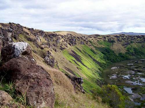
 The crater and knife ridge of Rano Kau. The knife edge ridge is between the crater lake on the left and the ocean on the right.
History of the Peaks
Easter Island was colonized around AD 300 by Polynesians from Marquesas or Mangareva. The long platforms (ahu) and the statues (moai) constructed at Ahu Akiva, which is at the trailhead for Maunga Terevaka were the last of all the ahu and moai on all of Easter Island and were constructed around 1460 AD. Other statues around the Island were constructed as early as 690 AD. These statues were portraits of known ancestors, were considered "living", and they looked towards a village to protect them.The site known as Orongo is on the summit of Rano Kau. Orongo was the main ceremonial site on the island and many petroglyphs of the "birdman" or on the stones surrounding the rim of the volcano. There are ruins of 47 stone dwellings on the summit of Rano Kau. For every September between 1460 AD and 1866 AD (406 years!), there were birdman festivals on the peak. A race was staged where the participants would make the dangerous swim to the off-shore island of Motu Nui to find the first egg of the sooty tern bird. The winning participant would then carry the egg to the top of the peak Rano Kau and would be proclaimed as "birdman". The winner was thought to posses supernatural powers.
 View from the summit of Rano Kau and down to Motu Nui, 324 meters below.
After about 1460 AD, the demise of the culture of the island began in earnest. Since the native peoples had cut down all the native forest, there was no way to escape the island. Over population led to tribal wars and cannabalism. Around 1460, it was thought that about 20,000 people lived on the island. By the time the Europeans (Jacob Roggeveens) arrived in 1722, the population was around 4000. In 1862, a fleet of Peruvian black-birders kidnapped 1400 of the people (known as Rapanui) to work in ght sugar plantations of Peru, and to work on off-shore guano mines. Included were the king and all of the learned class. Missionaries and diplomats in Peru protested, and eventually the 15 survivors were returned, but this set of a small pox epedemic. French Catholic missionaries and Tahiti businessmen contied to remove the native Rapanui starting in 1866. When some were returned to their homeland, they introduced leporsy, and by 1877 the entire native population of Easter Island was reduced to 110 persons.
 A "birdman" petroglyph.
In 1883 Chile defeated Peru and Bolivia in the Pacific War, and in 1888 Chile annexed the island, thinking it could be used as a port for travel to the Panama Canal. There was no place for a safe harbor, so they leased the island to a British wool operation, which controled the island until 1953. Unfortuantely, during this time period, the Rapanui people were not allowed to leave the capitol town of Hanga Roa. The first Rapanui governor was Sergio Rapu in 1984, and now the Rapanui people once again control most of the island. The current population is about 4500 people, and there is only one town on island, Hanga Roa.
This is a mountain page, not a history book, so the above is just a very brief overview. I highly recommend that you read up using several good books on the fascinating history of the island before your trip.
Getting There
The only way to get to Easter Island is by plane and LAN Airlines. I didn't have much luck trying to book online, but calling LAN is easy. The airline has flights twice a week between Santiago Chile, Easter Island (Hanga Roa), and Papeete Tahiti. The cost varies depending on the time of year, and we paid about $500 in November from Tahiti. Usually it cost about $100 more round trip from Santiago, because the flights are in more demand. Note: If searching online, note that it is cheaper to search and book the flights seperately, such as your city to Santiago (Chile) or Papeete (Tahiti) and then a seperate booking to Easter Island. Interestingly, the runway at Hanga Roa is the second longest in the entire Pacific. The US government expanded the runway in 1986 as an emergency landing spot for the NASA Space Shuttles!Once you are on the island there are several choices for getting around. One is via a tour group and many of these are based in the only town on the island, Hanga Roa. Another way is to walk, but distances are long to some areas. Another way is via mountain bike. A modern high quality mountain bike cost $13 a day to rent in November 2005. If you want some exercise, this is an excellent way to get around, and is highly recommended. Unlike the rest of Polynesia, Easter Island is not unpleasantly hot all year. You can rent a car or take a taxi. Taxis are pretty reasonably priced here. You can also hitch hike. There is no public transportation on the island. Note that the roads on the island aren't posted and don't seem to have names, so they are identified by location (i.e. South Coast).
Maunga Terevaka-Ahu Akiva Trailhead
To reach the trailhead, I recommend using a mountain bike or taxi. I paid $9 for a taxi from Hanga Roa, but this required a bit of Spanish. By using a taxi, you can walk all the way back to Hanga Roa by way of the West Coast, which is very scenic.
From Hanga Roa, mountain bike, hire a taxi, or drive from Hanga Roa. Follow the road towards Vaita, which begins near the International Airport. Turn north at the good gravel road marked for Ahu Akivi and follow the road to the site. You can't miss the trailhead, as there are seven huge moai statues at the trailhead! This place is 8kms/5 miles from Hanga Roa.
Rano Kau-Hanga Roa Trailhead
The beginning of the trail can be hard to find, but it is easy to get to since you walk from Hanga Roa. From the west end of the International Airport, walk along the road closest to the coast. Make sure to visit the cave and cave paintings along the ocean at Ana Kai Tangata. Follow the road as it turns east and inland. After reaching the Forest Service sign, look for a road on the right (south). There is a green gate just up the road. The road goes past a water tank and becomes a trail. It can take a bit of searching to find the correct start of the trail, but once you find the trail, it will be easy to find.
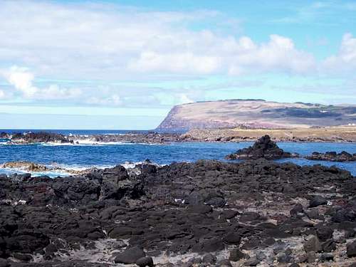 Rano Kau as seen from the South Coast and Ahu Vaihu. The peak isn't very high, but it starts right from sea level!
Routes Overview
Maunga TerevakaThis is a grassy and gentle mountain, so it can probably be climbed from any point on the compass. The route I took was the Maunga Terevaka via Ahu Akiva route. See the route page for more details. The route begins near Ahu Akiva, and climbs the south slopes to the summit. Once a week, 4wd vehicles in a tour group do climb to the summit, but there is no road; they simply drive across the grass. You can follow their light tracks all the way to the summit. If you don’t go on a day that there is a tour group, it will be a nice and pleasant walk. You can also return to Hanga Roa via the west coast. See the route page for details.
Maps indicate some sort of 4wd track or trail coming from Vaitea, but I am not familiar with that route. The peak looks easy to climb from other directions as well.
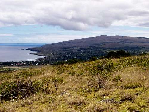 Maunga Terevaka (mountain) and Hanga Roa as viewed from the trail to Rano Kau.
Rano Kau
There is a road to within 1 km (0.6 miles) of the summit, but there is a nice trail as well. Obviously, the most interesting way up to the summit is via foot from Hanga Roa, and this is what will be discussed here. The trail starts at Hanga Roa, and climbs through a Eucalyptus forest before climbing to the crater rim where it meets the gravel road. The trail then leaves the road and follows the crater rim to the ranger station where it meets the gravel road again. The trail then climbs along the rim to the ruins and to the west summit. Apparently the east summit is slightly higher, but the west summit is more interesting.
See the Rano Kau via Hanga Roa route page for details.
From Hanga Roa, another trail up the mountain is visible, that stays closer to the coastline and its cliffs. I don’t know anything about the trail or where it starts. There is also a trail to the bottom of the crater and to the lake from where the trail first meets the gravel road, but since we didn’t know it existed until after our hike, we didn’t hike the trail. A trail is marked on my map to the east side of the crater rim and Vai A Tare, but I am unfamiliar with it. Walking all the way around the crater is not allowed anymore, because the route is considered dangerous, and some accidents have occurred.
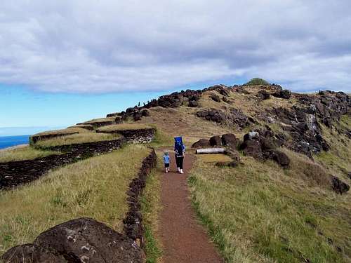 The summit of Rano Kau is just ahead as viewed from the north. The "Birdman Cult" (see the mountain page) ruins on the mountain are to the left.
Red Tape
The archeological ruins must not be climbed on or touched. Please do not remove any items from the sites.A $10 fee is collected for visiting the summit area of Rano Kau, and the fee is used to preserve the archeological sites of the island.
When To Climb
Anytime is a good time to come to Easter Island. The weather is about as perfect as it gets, at least temperature-wise. When we were there in November, the night were around 20C (68F), and the days were around 24C (74F). It doesn't get much better than that anywhere in the world.It actually rains an average of 140 days at Hanga Roa per year, but since the rocks are so porous, mud isn't really a problem, and the rain doesn't affect you too much when you are out hiking or climbing.
March to June are usually the wettest months, and September through December are usually the driest. February is the warmest month, and July to October is usually the coolest time of year. Anytime is still a good time to go, though the high season for tourism is November or December through March, and Easter (of course).
CLICK FOR WEATHER FORECAST
Below are the averages for Hanga Roa:
| Month | High (° F ) | High (° C) | Low (° F ) | Low (° C) | in. Rain | mm Rain | Rain Days |
| Jan | 79 | 26 | 67 | 19 | 2.9 | 74.5 | 15 |
| Feb | 81 | 27 | 67 | 19 | 3.2 | 83.7 | 7 |
| Mar | 79 | 26 | 68 | 20 | 3.8 | 98.9 | 16 |
| Apr | 76 | 24 | 65 | 18 | 5.0 | 130.4 | 15 |
| May | 76 | 24 | 63 | 17 | 5.4 | 141.1 | 12 |
| Jun | 70 | 20 | 61 | 16 | 4.4 | 115.8 | 16 |
| Jul | 70 | 20 | 59 | 15 | 4.3 | 108.1 | 12 |
| Aug | 70 | 20 | 59 | 15 | 3.5 | 90.0 | 9 |
| Sep | 70 | 20 | 59 | 15 | 3.6 | 92.1 | 14 |
| Oct | 72 | 22 | 59 | 15 | 3.4 | 85.0 | 6 |
| Nov | 74 | 23 | 63 | 17 | 2.8 | 72.2 | 9 |
| Dec | 77 | 25 | 65 | 18 | 2.9 | 75.7 | 9 |
 November shot of the east side of the crater of Rano Kau. Maunga Terevaka can also be seen in the far upper-right backgound.
Camping
There are campgrounds at Rano Raraku and at Anakena Bay on the north side of the island. Some of the budget guesthouses in Hanga Roa allow camping as well. Chez Cecilia is one place that caters to campers.Note that if staying on Easter Island, there is no need to have a hotel reservation as there are many more rooms than there are flights available to fill them. The hotels that are on travel websites are not as good as value as the homestays. Many of the homestays/guesthouses will meet you at the airport. We paid $50 a night for two children, two adults, breakfast for all, and transport to and from the airport.
Food is expensive on the Island, at least by Chile standards.
Mountain Conditions
CLICK HERE for current conditions and weather forecast for Hanga Roa on Easter Island. Hiking along the crater rim on the way to the summit of Rano Kau.