
|
|
Route |
|---|---|
|
|
37.96720°N / 119.3192°W |
|
|
Scramble |
|
|
Most of a day |
|
|
Class 2 |
|
|
Approach
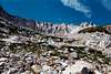
This is the easiest route from the east side, but may require ice axe and crampons in early season. Use the eastside trailhead at Saddlebag Lake. Proceed downhill below the dam toward southwest, through a sparse forest. A use trail is sometimes visible but not consistent. When you reach the bottom of the valley follow the old dirt road going straight west toward Mount Conness, passing the Carnegie Institute storage shed. Angle in the southwest direction after about 2 miles, following the drainage to its head.
 |  |  |  |  |
Route Description
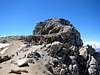
At this head of the drainage there is a moderately steep (30 degrees +) north-facing sand and talus slope. Ascend this slope (class 2) to the low point on the skyline, between Mount Conness on the right and White Mountain on the left. This slope may be snow-covered in early season. Once on the ridge, turn right to follow the broad south-facing slope up to the summit plateau, then follow the thin, exposed ridge on the northwest to the summit. The most exposed part is a narrow ledge on the left side of the ridge.
 |  |  |  |  |
Essential Gear
Ice axe and crampons are required in early season. In heavy snow years they may be required for the entire season.
Miscellaneous Info
If you have information about this route that doesn't pertain to any of the other sections, please add it here.