
|
|
Route |
|---|---|
|
|
36.65610°N / 118.3103°W |
|
|
Mountaineering |
|
|
Summer |
|
|
One to two days |
|
|
Class 4-5 |
|
|
5.6 (YDS) |
|
|
V |
|
|
Approach
First off, anybody considering this climb is also directed to this trip report as supplemental information.This climb can be attempted from a couple of places, depending on the intended route of descent. If the climb will be one-way over Williamson and down the Shepherd's Pass trail, then the starting point is the Shepherd's Pass trailhead; if the route will be retraced back down the NE Ridge, the start is slightly closer to the actual base of the route. If you are doing some other variation, you don't need my directions anyway! Either way, the initial directions are the same.
This info is lifted from the main Mt. Williamson page:
SHEPHERD'S PASS TRAILHEAD:From Independence, head west on Market Street for 4.2 miles. Turn left on Foothill Road, which is a dirt road. After driving on Foothill Road for 2.7 miles, you will pass a sign with a hiker symbol on the right and a “Symmes Creek” sign in the center. Keep left and continue for another 0.5 mile. Then, turn right at the intersection where the sign says “Shepherd Pass Trailhead.” Drive another 1.4 miles along a rough dirt road (but still passable with a low-clearance 2wd vehicle) bearing to the right until reaching the trailhead.
To park a little closer to the base of the climb, follow the above directions, but after turning right at the "Shepherd Pass Trailhead" sign, bear to the left instead of right towards the toe of the NE Ridge. Park at the end of the road (around 6200' elevation).
 |  |  |  |
History
According to R.J. Secor, the first ascent of the entire ridge from the mouth of Shepherd Creek was performed by Norman Clyde.[ Side Note: The Northeast Ridge route from ~9700' in Williamson Creek (skips much of the "fun" stuff) was first climbed in 1925 by Homer Irwin. The first winter ascent of this variation was made over a 5-day period in 1954 by John Ohrenschall and Warren Harding. ]
The first published car-to-car sub-24hr dayhike of the entire NE Ridge Route was accomplished by Barry Beck and Scotty Strachan in 2002. If you or someone you know did it first, post it here!
Detailed Route Description

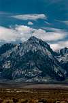
Overall this route up Williamson involves over 9,500 feet of elevation gain over a distance of 5 miles, with exposed camps and several long sections of 4th class terrain. In a couple places, light 5th class climbing is required for short sections.
This description is based on a no-snow, summertime climb, although occasionally this route is attempted in the winter (taking several days to complete).
There is *NO* water along the route, unless in the form of remnant snow.
The start elevation depends on season and parking area chosen. This can vary from 6300' at the Shepherd's Pass Trailhead to ~5700' on the road below at times of high snow accumulation. Either way, the 6100' mark must be passed when crossing Shepherd Creek to gain the toe of the ridge proper.
Cross the brush-saturated Shepherd Creek and ascend the slope to gain the point of the ridge. This first 3000' is basically all sand (decomposed granite) and low brush with a few trees mixed in (about 1.5 miles long, starting from Shepherd Creek).

Once the ridge itself is gained, the pure sand changes to mixed rock/sand/brush (lasts for about 1 mile). There is really no easy way through this section, so follow the points of least resistence (usually on the left for this first section).

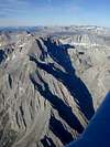
Around the 10,300' mark, the real rock starts, with the ridge making several large undulations that are difficult to negotiate (lasting about 0.75mi). The first one may either be passed on the right side by dropping onto some 3rd-class slabs via a narrow notch, and contouring to the far side, or else doing a 4th-5th-class traverse over the top (~300 yards or so).

The rest of the "humps" in this section have rather steep sides, and probably the best route is to stay on the crest. There are several airy 4th class moves on this section, and maybe even some light 5th class stuff. If you bail off the crest proper onto the talus slopes below, stay to the left (south) side of the ridge.
At the end of the undulations (~11,000') the ridge turns almost 90° to the left, and is broken by a large, highly visible notch. In order to pass this obstacle, either climb up the gully below the notch (5.8+), or traverse up the face on the right of the notch from right-to-left, staying below the crest on small ledges. Negotiate a couple gendarmes just before the notch, and then cross it (with decent exposure).
After this notch, either continue up along crest on 5th-class rock, or else take a small rocky ramp down on the right side of the crest. Follow a series of these (class 3-4 moves) along the right side of the ridge towards a long talus slope facing northeast. Climb this talus to the top of the slope (0.5mi), and get ready for one more technical spot before the Horns.
Stay on the crest and negotiate some more 4th class moves, passing obstacles on the right. After a couple-hundred yards of this, the base of the slope to the East Horn is reached. Ascend this talus to Horn, and sign in.

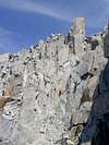
To negotiate the Horns, some rappels may be desired. This route stays on the north (right) side of the crest, and involves ~5.6 downclimbing. If you find a better way, post it here! Drop off the East Horn on the west side, just to the left of a prominent vertical block. Follow some slippery slabs around a corner to the right, and rappel (or downclimb) a 30-40' chimney/chute.[img:9800:alignleft:thumb:]
Look for slabs and ledges leading west towards the second Horn. The West Horn is easily ascended via 3rd class rock.
Drop off the West Horn on the west side, on the right side of the crest leading towards Williamson's summit plateau. A pair of notches in this crest beckon, and follow a steep chute to the first (and smaller of the two). The other side is an easy class 3 slope to the base of the plateau. Traverse south (left) below the plateau for less that a hundred yards, and then turn right up the sandy slope to gain it. Cruise across the level ground to the summit hill. [img:46003:alignleft:thumb:]
Descent: back down the NE ridge route (yikes!), or follow the tourist route to the Shepherd's Pass trail.
Essential Gear
Water. Lots of it. You won't find any along this route until you descend into the Williamson Bowl on the way to Shepherd's Pass. Better yet, plan to climb when some remnant snow exists.For the class 4-5 sections, a rope, harness, pro (chocks, cams, runners), and helmet are highly recommended. The "pitches" wouldn't be very long, but a decent variety of pro would be handy. A winter ascent will add various other items, which could include a shovel, avalanche beacon, ice axe, crampons, snowshoes and the necessary winter clothing.
Common sense. This is a committing, challenging route, any way you cut it. There are no easy "bail off" routes, crowded trails nearby, or places to land an airliner (until you reach the summit). Plan carefully, and use your head. I'm not really interested in finding any bones besides those of Bighorn Sheep next time I go up.
Page Metadata
This route was first submitted to SummitPost by forjan, and was later transferred to ScottyS.The description is currently tuned for summer (snowless) ascents, as the very nature of winter conditions dictate that the route could vary greatly depending on snowpack makeup.
Any additional route details for any season are welcomed, as the committing nature and length of the route ensure complication...