-
 69720 Hits
-
 86.14% Score
-
 22 Votes
|
|
Route |
|---|---|
|
|
45.83270°N / 6.86430°E |
|
|
Mountaineering |
|
|
Spring, Summer, Fall |
|
|
A long day |
|
|
PD+ |
|
|
Class 3 |
|
|
II |
|
|
Historical Notes
1st ascent by Giovenni Bonin, Luigi Grasselli and Achille Ratti with Joseph Gradin and Alexis Proment - Aug 1, 1890 (in descent)
1st winter ascent by Graziadio Bolaffio with Joseph and Alexis Croux, Cyprien and Albert Savoye, Laurent Petigax.
It's interesting to note the above mentioned Achille Ratti would later become Pope with the name Pious XI.
Overview
WARNING: This is an alpinistic route. Because of lenght and altitude, in order to climb it succesfully you must have have a sufficient physical and technical preparation, and a clear meteo. In case of doubt or for further information, contact the The Company of Guides at Courmayeur (www.guidecourmayeur.com) or the Fondazione Montagna Sicura (www.fondazionemontagnasicura.org)
It's not a terribly difficult route, more varied than the French normals and far less crowded. The ambient is incredible, much more savage than any other normal route to MB. However, you'll have a longer summit day than the Gouter route (1700 m. of altitude gain against 1000) and the climb itself is less banal and a bit more demanding. A great advantage of this route compared with the Gouter is a much lower hut. It's guaranteed that you'll sleep far better here, and you'll be more fresh for the summit day (you're going to need it!) In doubt, hire a guide! The Company of Guides at Courmayeur (www.guidecourmayeur.com) has some interesting package for people who wants to attempt MB for the first time from this side.
Approach
The route starts at the Francesco Gonella hut, located at 3072m above the Italian Miage glacier. The hut can be reached from the Val Veny.
Route Description
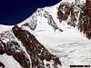
From the hut there's an evident path on what is usually a snowy slope, but in recent years it has always been reduced to dry scree. Follow the path until you reach the Dome glacier. From here, in summer there's usually a well marked trace, that can be difficult to follow in the dark. And so, first climb up the glacier on the left, then on the center, taking care of the crevasses (usually well open in summer). Above, the glacier trail turns left again pointing toward an evident col betwen the pointy Tour Des Aiguilles Grises and the massive Dome De Gouter. Cross the bergschrund (usually easy) and go up a easy but steep snowy slope until the col (3811 m.). Follow the ridge on the right (snow with some rocks) until a minor summit called Piton des Italiens (4003 m). Again, continue on the snowy ridge (beware to some cornices) until the summit of the Dome De Gouter (4 or 5 hours from the hut). From here, you meet the trail of the Gouter normal route that goes (in a little less than 3 hours) up to Mt. Blanc,
Some note on the descent if weather deteriorates: If you want to use this route in descent, the bit around the Dome De Gouter can be very awkward with reduced visibility. Most of the traces go toward the Gouter hut, in the NW, while you've to turn SW towards the Bionassay ridge. Follow the ridge (first relatively large, then narrow) until the small bump of the Piton Des Italiens. If visibility is scarce, check the compass (that you MUST have!) and follow the steep ridge South, then (when the angle become easier) turn left (East) an follow another steep but easy slope until the Dome glacier. Descend the glacier first on the middle, then turn right. The hut isn't visible from here, but leave the glacier to the right when you reach a small but very evident plateau (as reference, on the opposite (left) side of the glacier you'll see the massive couloir normally used to link the Gonella and the Quintino sella hut. In good conditions, the descent from the summit to the Gonella hut takes only 3 or 4 hours, but may get easily longer. It's ALWAYS a good idea to ask directions and suggestion to the Gonella warden before you leave, and to familiarize yourself with the area. Bring a map and a compass, or a very good GPS.
 |
 |
Essential Gear
I've made a gear list using the "official" one from the St. Gervais Bureau Des Guides as a blueprint, adding my own opinions. As usual, use with caution.
- UIAA tested climbing rope (50m), suited for glacial environment. (will be provided by the guide if you hire one)
- Some (2 at least for each member) 8 mm. cordelette loops, 2 m. long, + plus a 2 m. tape sling. Invaluable for self rescue. (will be provided by the guide if you hire one).
- High quality rigid mountain boots, allowing for use of crampons.
- A pair of hiking shoes for the return walk from the hut.
- Helmet.
- Long shafted, light ice axe (choose according to your height).
- A couple of telescopic walking poles
- Crampons with the anti-bailing plate. Until very recently the "clip on" type was mandatory, but now there are new models with a sort of mixed "heel clip - front strap" that I really consider safer. Don't spare money on these. Be sure you know how to put them correctly, and check the binding. If you hire a guide, have him check the bindings for you.
- UIAA tested climbing harness.
- A couple of locking biners for each party member.
- A good rucksack (35 lt.)
- High altitude clothes, including a good down jacket with hood. Must be breathable. Also, fleece garments (jacket and trousers). The whole mountain clothes thing has been discussed to death, and I’m afraid that many suggestion I’ve seen around have more to do with fashion that practical consideration. The principle you must follow is that you must have a multi-layered clothe system (three layers), that the exterior must be windproof, and that you must have some spare clothes. If you hire a guide, discuss
- Gaiters.
- Undergarments specific for altitude
- Balaclava and scarf.
- Altitude socks, two pairs
- A good fleece or wool hat. Bring also a baseball type hat.
- Two pairs of gloves - one light and the other padded (I use snowboarding gloves). Bring also a pair of wool mittens, just in case
- Two pairs of mountain goggles (I use ski masks).
- A good, reliable frontal headlight with spare batteries (these are very, very important! )
- A very good sunscreen. Take the one with the highest protection. When I say the highest I mean "something that's going to block every single harmful radiation whatever the sky conditions". Believe me, at high altitude cloud cover doesn't mean you're not going to roast.
- A good thermos with plenty of liquid, water, Enervit, tea, whatever you fancy. I prefer tea with lot of sugar. (once below a certain altitude I switch to grappa, but that's another story ;))
- Something to eat – some snack bars, for instance. You're not going to eat much once up the mountain, so don't bother bringing plenty of stuff. What you need is something to drink!
- Aspirin, some bandage, a good disinfecting liquid and some toilet paper.
- A good, recent, local map. (will be provided by the guide if you hire one)
- A compass + altimeter (will be provided by the guide if you hire one)
About GPS and cell phones: everyone seems to consider them invaluable stuff for safety and self rescue, but reality is that they simply lull you into a false sense of security. Especially the cell phone - a lot of places in the Mt. Blanc massif are NOT covered, and believe me, you're going to discover you're in a "blank" area just when things are going bad! Guides of the area often use two way receivers. As for the GPS, is a fantastic tool, but it doesn't replace stable weather, good visibility and the navigational abilities you need to be a competent alpine climber. The best equipment you'll bring is a fit condition and a careful acclimatisation for altitude. To climb safely Mt. Blanc from ANY route you must be fit enough to ascend at least 1500m. of altitude gain without feeling exhausted, and you need to have done at least a peak above 3500m. and one above 4000m. in the previous two weeks. Anything less means courting disaster (most of MB casualties are altitude related). Remember - it's true that an helicopter can take you to the valley in minutes, but not always you can call for rescue (cell phones don't work well here), and not always the weather conditions allow the helicopter to land on the mountain.
Trip Reports
From Courmayeur to the Gonella hut