
|
|
Route |
|---|---|
|
|
40.27884°N / 105.6532°W |
|
|
Mountaineering, Scrambling |
|
|
Most of a day |
|
|
Class 2 |
|
|
Approach
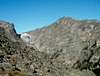
The northeast slopes of Thatchtop are approached from the Glacier Gorge trailhead. Follow the signs for Mills Lake. Soon after the trail for Loch Vale branches to the right, the trail for Glacier Gorge crosses Icy Brook, which is the stream coming out of the Loch. The route starts at the south side of the bridge.An alternate approach takes the branch that goes to Loch Vale at the fork, and then leaves it at the first switchback to cross Icy Brook and follow it downstream until it meets the route described here.
Route Description
The north face of Thatchtop is guarded at its base by a cliff band, which hosts some of the most challenging ice and mixed climbs in the Park. The route exploits a chink in this armour consisting of two gullies. Immediately past the bridge described in the approach section, locate a faint trail that follows Icy Brook upstream. The trail grows even fainter when it reaches the foot of a prominent talus-filled gully. The climb up this gully is strenuous, but uncomplicated. From the top of the gully follow cairns to reach a peculiar S-shaped gully that winds up the upper part of the cliff band. This second gully is filled with rather loose scree. The upper reach of the cliffs roughly corresponds to treeline, so that at the end of the S you are greeted by krummholz. A bit of mild bushwhacking takes you to the alternation of talus and tundra that goes up to the top. Given the shape of Thatchtop, the real summit, marked by a cairn and a wooden stake, becomes visible only toward the end of the long and steep ascent.If you plan to descend along this route, try to remember where you left the krummholz, since locating the top of the S-shaped gully is critical. Alternatively, descend on the south side via the south slopes for a longer but more rewarding itinerary.
 |  |