
-
 19254 Hits
-
 77.3% Score
-
 8 Votes
|
|
Route |
|---|---|
|
|
39.22500°N / 106.1692°W |
|
|
Hike |
|
|
Half a day |
|
|
Walk-up |
|
|
Overview
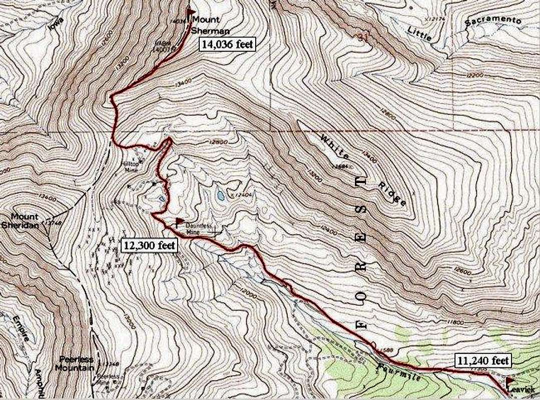
The hike to Mount Sherman's summit from the Fourmile Creek Trailhead is considered by many to be one of the easiest routes to a summit of any fourteener in Colorado. This is Mount Sherman's standard route, and the route recommended by Colorado Fourteeners Initiative, because "use of this route will help to reduce impacts to this Fourteener's fragile alpine environment."
Distance, round-trip: 8.0 miles (only 3.0 miles from 4WD parking)
Elevation Gain: 2,800 feet (1,500 feet from 4WD parking)
Note: Do not be fooled! Just because this may be an "easy" route by Colorado standards, does not mean you can take it for granted that you are heading to 14,000 feet. Weather can turn any good day into a bad day quickly, especially at higher elevations. In fact, the first time I tried this route, I was turned back by a Memorial Day snow-storm. Always start early, be aware of the weather forecast, and prepare for the worst.
Approach
Start from the Fourmile Creek Trailhead, as described on the Mount Sherman Main Page, HERE. The trailhead and camping area at 11,240 feet can be accessed with any passenger vehicle. If you have a 4WD vehicle, you can shave 2.5 miles and another 500 feet of elevation off your hike by continuing up the rougher road to where it is gated off, just below the Dauntless Mine.
 |  |  |
Route Description
Continue walking up the dirt/stone road on which you parked. Shortly you will pass the Dauntless and Hilltop Mines, where there are some interesting old mining buildings. Mount Sheridan is on your left (southwest); Mount Sherman is on your right (northeast). Do not be confused by all the mining roads, but continue straight up the hill to the 13,140-foot saddle between those two mountains. Once on the saddle, follow the trail to the right (northeast) along the crest of the ridge to Mount Sherman's summit. This is a pleasant hike most anybody in good shape can do, and it is not far from the cities of the Front Range.
Other mountains you might consider climbing while parked at the Fourmile Creek Trailhead:
Horseshoe Mountain - 13,898 feet
Mount Sheridan - 13,748 feet
Gemini Peak - 13,951 feet
 |  |  |  |
Essential Gear
Common Sense.
djilk - Jul 5, 2005 2:24 pm - Hasn't voted
Route CommentAs a more challenging alternative to the saddle, ascend the darkened scree slope about halfway up (east/right) on the ridge. This takes you to about 13,600', and portions are class 3 with slippery 45-50 degree pitch.
We took this route by mistake while following the first group up in our early morning grogginess... the route is creating something of a gash in the mountain so you may want to avoid this route for environmental reasons.
djilk - Jul 5, 2005 3:46 pm - Hasn't voted
Route CommentGerry Roach's popular 'Colorado Fourteeners' book shows the 4WD parking in the wrong place on the map. It has the altitude correct, but it shows the location far up the road/trail from where it really is. It's also fairly hard to identify the passenger car trailhead unless there are already cars parked there.
seano - Jan 18, 2010 12:30 am - Hasn't voted
Winter routeIn the winter, if the snow has hardened up, it makes for a nicer climb to pick a snow-covered line straight up Sherman's face. The 45-50 degree snow is very efficient, but I can't imagine climbing the underlying talus-pile would be pleasant. Also in winter, you can avoid wandering along the mining roads by following the prominent gully between the parking lot and gate.