
|
|
Route |
|---|---|
|
|
8.9333°S / 77.7°W |
|
|
Ice Climb |
|
|
Most of a day |
|
|
MD |
|
|
Approach
Already in Cashapampa, one is due to make of you transact them more classic of White Mountain range: to contract to a carrier and his donkeys to transfer the load until the field bases. Fact this, only lack to pay an access entrance to the valley before putting itself to walk.
The approach normally lasts of 2 days. During first of them, it is walked by a dusty footpath that goes by the South margin of the river. This caminito winds from a side to another one until entering the flat part of the Valley Santa Cruz. The gorge, in its low part, is simply wonderful, full of trees, pozones of water, granite strong walls, etc. The march passes during +/- 4 h. until arriving at a quite ample esplanade, where there are a pair of huts and potreros in where it is possible to arm the camping of approach. This place is known by the name of Llamacorral.
During the second day it is necessary to arrive until the field bases of the Alpamayo, for which one is due to continue by the footpath that advances by the South margin of the river. After a pair of hours of long walk a sector is arrived until a where place is possible to observe the South wall of the Quitaraju in all its east splendor is incredible! Soon, it is continued advancing by the track until arriving at the Jatuncocha Lagoon or Great Lagoon and is bordered completely by its South border. To the other side of the lagoon, the way loses a little in the esplanade but at some moment it is possible to descry a puentecito that allows to cross towards the North shore of the river. The long walk continues now by the North part of the valley until arriving at a leafy forest, that is ideal to stop to have lunch. Passed the forest, the track turns abruptly towards the north in a zigzag that takes enough height and enters completely to the Broken Arweicocha. The footpath goes into almost until the end of the gorge, where is a spectacular forest of called trees Queñuas. In this place the field mounts bases (height approx: 4000 msnm).
Route Description
First section:
Ascent from CB to Field Moraine.
From the CB a footpath not very sure is due to take but that in broad strokes it is identified like so, and that raises by the Face This of the hills Alpamayo and Quitaraju in the direction of the col that these two form. By that track, that advances during first half between shrubs and some trees, it is gained altitude until leaving back the vegetation and beginning to walk on granítica rock. Here, it is easy to lose the track and it is common to have to make a pair of gateos in rock to advance (to pay attention, with much care, of the stone monolith existence that guide the route, although sometimes they are lost).
To about 50 meters under the inferior margin of the Glacier This, they are small pircas on the rock in where it is possible to arm carps. The approximated height of the Field Moraine is of 4600 ms.
The day between CB and cm does not have any technical complication, although she is very cansadora due to the pending pronounced one and to the weight of the knapsacks.
Second section:
Ascent from Field Moraine to Camping Col.
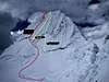
Already in the inferior margin of the Glacier This of the Alpamayo, the march is taking height while it advances by smooth slopes; in the beginning, cracks skip and it is done to him clears to others. Thus, and after walking 3 hours, it is arrived indeed at one from the most delicate and exposed zones from the ascent: the Quitaraju-Alpamayo col. The section begins with a snow scaling by a slope of 30-45°, surrounded in the South side by seracs giant and in the north by a vertical granite wall. Also it is necessary to go prepared to scale a pair of meters in vertical ice. Just before leaving to the col there is a last one very exposed under threatening serac; nevertheless, this happening can be avoided climbing in line straight towards the col, which implies a quite greater effort much more but surely. Already in the col, it appears spectacular wall SW front of the Alpamayo that leaves overwhelmed simply to any climber by a pair of minutes. The camping col is to about 30 meters of this place. Height approx: 5400 ms.
Third section:
Ascent from Camping Col to the summit.
The day lintel usually starts off very early since she is enough long, although varies much according to the advance of the season (between 4 and 8 hrs). During the first weeks, although the route is not equipped, the conditions as much of the snow as of the ice in the canal they are perfect. However, during the last weeks, the passage of the many cordadas ones that try to scale the snowed one by this route, is eroding the snow and the ice, reason why the route, although it is equipped with some stakes in the meetings, it is put exposed much more since the ice of the last lengths is an ice rotted that bursts and it is given off with facility, doing very dangerous the situation for the companion enough who is down. By this same reason it is important to leave early and to try to be the cordada one of end and thus to avoid the exhibition to the material fall that the cordadas ones of above produce.
The wall has a total unevenness of 700 ms. From the Camping Col it is necessary to lower a good one little and for advancing towards the NW in the direction of the Ferrari canal. Before arriving at the same wall a quite wide crack by a snow bridge is due to cross, that it connects to the slope that takes until the canal. Before beginning to scale the canal one is due to surpass rimaya something complicated. In fact, many cordadas usually arrive only up to here since this step is not trivial, specially during some seasons.
The canal has an approximated length of 350 ms, which implies about a 7-8 lengths of scaling in snow and ice. The first lengths are by a very hard and resistant snow that allows to nail firm piolets as much as crampones. The securing is possible with stakes for snow. The final lengths, depending on the season - as it were mentioned previously are in ice and one is due to assure with the corresponding screws. The intermediate lengths have as much snow as ice.
The summit is simply impressive. Not only by the panoramic one to the others snow-covered or the vertiginous Vista of the camping Col, but by the thin edge that is its summit.
Important:
This route has a tremendous ice fungus in its superior part what it turns it a route very exposed. The fall of this fungus would have catastrophic consequences. Also, the summit is extraordinarily thin and with cornice sections. Taken care of much.
 |
Essential Gear
By cordada:
Equipment of camping discharges from the hospital to montaña(incluir snow stakes for the carp)
2 prudent droughts
6 stakes
6 to per of ice
tapes to us express
and tapes of relief lugs with
and without insurance cordines
By person:
Shelter and footwear of high
2 mountain piolets
crampones
harness
helmet
optional: jumares
Miscellaneous Info
If you have information about this route that doesn't pertain to any of the other sections, please add it here.
Andinista - Feb 27, 2005 1:26 am - Hasn't voted
Route CommentThe months of good weather are June, Julio and August. Although the time usually changes suddenly, is known that there are good and bad seasons from the climatic point of view. Another important variable is the moon change that make worse the climate during about 3 to 5 days, with rains, snow-covered and low clouds.
To be a hill highly visited, the Basoue-French route of the Alpamayo is changing its level of difficulty as it advances the season. During the first weeks, it is common to be with snow wave, which long ago more desgastante the advance, and obvious the route is free from previous anchorages. On the contrary, if the last weeks of the season are chosen is possible to be with a good track of affluent hard snow, edges of cracks demarcated and the route equipped with stakes in the meetings
Andinista - Feb 27, 2005 1:33 am - Hasn't voted
Route CommentCarriers: Always there are problems, to leave in Cashapampa whatever neat is going to cost this service altogether (to include roundtrip). The cost of this service is greater in Broken Santa Cruz who in other neighboring valleys.
If it is arrived early at Cashapampa is possible to be made the day of approach in a day, although this will be subject to the good will of the carrier.
End taken care of with seracs in the access to the col between the Alpamayo and the Quitaraju.
There is water in all the passage during the approach as also in the field bases, in the Camping Moraine and Col is necessary to fuse snow.
In order to arrive from Lima at Huaraz, it is recommended to go to the centric Ormeño terminal of the Peruvian capital.
He is recommendable to be acclimated well before trying to scale the Alpamayo.
More information in House of Guides, Huaraz.
Andinista - Feb 27, 2005 1:39 am - Hasn't voted
Route CommentHuaraz - Llamacorral.
Llamacorral - CB
CB - Campo Morrena
Campo Morrena - Campo Collado
Campo Collado - Cumbre - Campo Collado
Campo Collado - CB
CB - Huaraz
Itinerary for acclimated montañistas
KevinCraig - Aug 26, 2006 6:33 pm - Hasn't voted
Photo correctionI'm pretty sure the route labelled as the "French Direct" in the photo that also shows the Ferrari and the Basque-French is incorrect. The starting point is correct, but the French Direct takes that next gully to the right and finishes much closer to the summit. At least that's the way we climbed in June 2006. See the photo at http://www.summitpost.org/phpBB2/viewtopic.php?t=20205