
-
 9204 Hits
-
 74.92% Score
-
 5 Votes
|
|
Route |
|---|---|
|
|
48.98210°N / 121.0119°W |
|
|
forest, snow, rock bands |
|
|
One to two days |
|
|
Class 4 |
|
|
1 |
|
|
IV |
|
|
Approach
>Drive the Silver-Skagit road from 1.8 (3km) miles W of Hope, B.C., south 37.5 miles (60.3km) to the border crossing on the E shore of Ross Lake. Look for the Trail of the Obelisks near the border that climbs up and along the boundary. We drove there on Friday night to get an early start. Much of the approach is steep, dry, W-facing forest – you'll want to be past that before noon.Route Description
The Trail of the Obelisks will take you up onto a marshy bench at 1,820 feet (555m) and join the logged swath that follows the 49th Parallel up the mountainside. Don't expect too much of the trail; it's there to satisfy the curiosity of campers who want to see a border monument, but for most of the ascent you'll be picking your way up through forest. The route takes advantage of the border swath, but does not follow it consistently. At about 4,000 feet (1220m) bear right and follow a small creek valley (no water when we were there in late July) to a pass just below 6,400 feet (1950m).
Step into the broad, open basin NE of the peak and soak up the views. Head straight for the peak and the chain of permanent snowfields and rock bands that take you to the top.
When Leonard and I descended we continued N until we hit border monuments, then turned W and descended toward Ross Lake. Routefinding didn't seem like an issue.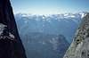 |  | 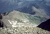 |  |  |