
-
 10704 Hits
-
 73.06% Score
-
 3 Votes
|
|
Route |
|---|---|
|
|
28.73000°N / 17.87°W |
|
|
Hike (Treck) |
|
|
A few days |
|
|
Walk-Up |
|
|
Approach
See the Getting there info on the main Page. The trailheads are at Puerto Tazarcote on the west coast and Ermita de la Virgen del Pino in the centre of the island.Route Description
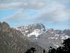
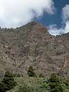
 Overview of Caldera de Taburiente as seen from the foot of Pico Birigoyo Overview of Caldera de Taburiente as seen from the foot of Pico Birigoyo |
- Start altitude: 1100m
- Summit altitude: 2426m
- Prevailing exposition: all directions
- Type: 14h along well marked paths
- Protection: marked
The Ruta de la Cresteria around the Caldera de Taburiente is one of the most scenic trecks on this planet. It is a two day affair if you start from the Ermita de la Virgen del Pino (14h) but will get a three day treck if hiked in the other direction from Puerto Tazarcorte. There is only one "hut" the Rifugio de la Punta de los Roques, which is rather close to the start/end at the Ermita. Consequently you'll have to sleep out under the open sky. Camping is not allowed anywhere near the Caldera.
If started from Puerto Tazarcorte on the western coast of La Palma the Ruta de la Cresteria can be combined with the (almost equally) beautiful Ruta de los Volcanes across the southern half of the island, the Cumbre Vieja range. In this case allow at least four days (better five). As you'll only find one place where you can stay overnight - the Rifugio Pilar right in the centre of the island - this treck should only be done in stable weather conditions. In other words: only do it in the summer months.
The following description starts from the Ermita de la Virgen del Pino. From Puerto Tazarcorte you would have to climb about 2000m on the first day of the treck so that most trekkers start out from the Ermita.
Due to the weather in Febuary I didn't do the treck in its entirety. We went along most stages in single day trips, however.
Stage 1: Ermita - Reventon - Punta de los Roques
The nominal trailhead for Ruta de la Cresteria is the Ermita de la Virgen del Pino a little east of the town of El Paso. It is located directly beneath the steep slopes of the Cumbre Nueva Ridge and offers the shortest access route to the crest via the Reventon Pass.From the Ermita head out along a trail which at first resembles a potholed forest road. It leads through the beautiful pine forest between two field walls. After a while (30min) the "road" leaves to the right (south) while the trail turns into a cobblestoned Camino Real (King's Highway). This is the "new" Camino Real as opposed to the "old" one across the Cumbre Vieja. Interestingly these trails gave way to the name of the two mountain ranges though geologically Cumbre Vieja (Old Mountain) is by far the younger one.
The Camino Real heads along a ridge towards Reventon Pass and often offers views into the caldera through the Cumbrecita Saddle. Also Pico Bejenado to the south of the caldera can be perfectly seen. On Reventon Pass turn left (north onto the Cumbre Nueva Ridge). The trail (already called Ruta de la Cresteria) now follows the ridge and after 45min reaches Pico Ovejas, the first higher summit (at 1854m). A little to the north of Ovejas you can find an escape route (PR LP-2) to the east but it is so steep that in case of danger you should consider turning round.
From Pico Ovejas the crest trail steadily climbs toward Pico Corralejo which it circumvents on its western side (30min). Another 30min take you to the Refugio de la Punta de los Roques and to the Punta itself (2085m).
 |  |  |  |
Stage 2: Punta de los Roques - Pico de la Nieve - Pico de la Cruz
From Punta de los Roques you need to descend to the pass Degollada del Río (1922m) which is a steep scree descent (30min). Pico del Cedro, Pico de la Veta de la Arena and Pico de la Sabina are all passed on their eastern sides (very short ascents to the summits) until you reach one of the rock drawings of the Guanches (La Erita Tagoror, 1h), the original inhabitants of the Canarias. A short ascent (30min) leads to Pico de la Nieve, where you can find the next escape route (eastward in 1h30min towards the La Palma high road LP-22).From here on escapes to the road are possible from all parts of the Ruta de la Cresteria until you reach Roque de los Muchachos. Mostly they are trail-less but between Pico de la Fuente Nueva and Roque de los Muchachos you will find paved roads (serving the telescopes).
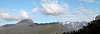
Between Pico de la Nieve and Pico de la Cruz the crest trail is very scenic but easy to describe. The summits of Pico de la Nieve Pico de la Cruz (a little namesake north of Nieve) and Piedra Llana are passed on their eastern sides. You can easily reach the summits by trailless short 50m (elevation) scrambles. In between the summits you always reach equally scenec passes which offer gorgeous views into the steep and narrow gorges (Barrancos) leading into the crater. Pico de la Cruz is located directly west of the road LP-22 and thus is one of the most popular peaks. From its summit you can directly look into Barranco de las Angustias and down to the western end of the Caldera near Puerto Tazacorte.
Most trekkers spend their night on or around Pico de la Cruz.
 |  |  |
Stage 3: Pico de la Cruz - Roque de los Muchachos - Roque Palmero
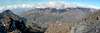
The stage between Pico de la Cruz and Roque de los Muchachos is every bit as scenic as the stage before only you have to account for a lot of tourons. The road LP-22 runs parallel to the trekking trail and while emergency descends are easily possible lots of badly equipped hikers reach the rim. Moreover there are a couple of parking lots near great lookout positions which you as a trekker have to cross. Start out early from Pico de la Cruz and you will have the place more or less to yourself (and other trekkers).Until you reach Pared de Roberto the trekking trail runs parallel to the road and there is not much to mention about it. Here the road draws real close and the trail runs through the inside face (south) of the mountain. There are wonderful basalt walls which gave rise to the name and beautifully coloured slopes. From Pared de Roberto on the road retreats to the north but leaves two side roads which serve the observatories. They are closed to public access most of the time and can be used as escape routes. Also in times of emergency you surely can pay a call to the scientists which have their headquarters to the north of Roque de los Muchachos close to LP-22.
The trekking trail crosses Fuente Nueva, Cruz del Fraile and finally reaches Roque de los Muchachos, the highpoint of the trail (and the island). Don't be put down if you find a parking lot almost on the summit of this otherwise beautiful mountain.
Next we have to follow the paved road for 10min befor a forest road turns off which again leads to the crest. The trail leaves this road after having left behind the last telescopes and now again passes the summits on the outward side of the Caldera. After Roque Chico is passed there is a slow descend to Degollada de las Palomas, before Roque Palmero is reached. The trekking trail again passes the summit but it pays to climb it (even though the scramble is trail-less). Again (or still you can admire those views through steep Barrancos into the caldera.
Escape always back to Roque de los Muchachos. From Roque Palmero you can descend to Tinizara in the west but this is a 1400m descent!
 |  |  |
Stage 4: Roque Palmero - Sommada Alta - Puerto Tazarcorte
The last stage of the treck far less beautiful than the other four. Between Roque Palmero and Sommada Alta you still have the same beautiful views though now pines populate the crest and somehow obscure the views. Still the tral leads around the outside of any summits, first Morro Pinos Gachos, later Morro del Estrabito. It finally reaches Sommada Alta after 45min.Through the ever deepening pine forest the trail reaches Risco de las Pareditas and finally Hoya Grande and Torre del Time. Here you can find the next escape route towards the village of El Jesus but going on along the trail is almost equally short and fast. Torre del Time is a fire lookout which offers the last view towards the caldera and Barranco de las Angustias. From there on those views are almost always hidden behind trees and rock walls.
You reach La Palma's main road LP-1 near Mirador El Time, a restaurant with a view where you can finish the treck. However it is worthwhile to descend to Puerto Tazarcorte which means crossing a small village and then descending the beautiful steep face of El time directly above the sea. This is a worthwhile finish for the treck and you can relax in one of the bars or restaurants (or even the beach) of Puerto Tazarcorte.
 |  |  |  |  |
Katekat - Mar 25, 2008 3:12 pm - Hasn't voted
Pico de la CruzThere is a possibility to make an overnight stop at Pico de la Cruz where is great place to sleep. I can highly recommend this place, especially for watching the clearest sky in Europe (I haven´t seen Milky Way before!) Didn´t want to sleep as per the clear sky with thousands of stars even it was frezing up there! Can´t express the next day sun rise as this is was one of the best I have ever seen! Nicer than one on top of Spain (Pico del Teide).