
|
|
Route |
|---|---|
|
|
28.0188°S / 68.756°W |
|
|
Mountaineering |
|
|
Expedition |
|
|
Class 3 |
|
|
Max. 55 degree ice/snow |
|
|
Approach
When leaving the bumpy and dusty path leading to the mountain, you will have a good overview of the peak´s S and SW approaches. The obvious choice is to head for the very small glacier almost in the middle of the peak. It´s not a long way to walk from where the 4w drive had to stop. The vertical gain from this point to where you can find water is about 300m. Count on a quite easy walk on sand and gravel.The glacier is small, but there are running water and good shelter from the wind here.
The location is:
28*03'21,7 S
68*48'35,2 W
The altitude a bit over 5300m.
The distance to the peak is over 6km, the way the bird fly.
Some people would think; This is a long way to the summit and it is. It´s a long day, or you can head further up and set another camp before heading for the summit.
Route Description
 The second highest point of Bonete Chico
Leaving the camp described above, you walk up a narrow and quite steep valley until you have left the glacier and the penitents behind you. Go straight up to the ridge on your rigth to get a good overview of the area and to make the distance shorter. Cross some almost flat fields of rocks and scree, direction NE. Try to walk towards the upper part of the SW face, as this is where you want to end up sooner or later. There are some ridges running out onto the plateau. Walk below and around them and aim for the main valley below the SW face.
When at the foot of the wide valley, which further up the mountain can be classified a couloir, you better put your crampons on. Mixed walk and scramble up the contstantly steeper ground. Those who want to make it easy for themselves continue straight on to the end of the couloir and on to a ridge. Pick a line that looks interesting on the face. The steepest slopes you´ll find almost at the end of the wall. It looks very steep, almost vertical from a distance, but I think it´s hard to find sections with more than 55 degrees.
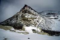
 The summit pyramid of Bonete Chico
Climb up to the top of the snowfield. You´re now on a ridge and in front of you a large plateau appears. On the other side of this field, a couple of hundred meters away, you see three pyramids. I encountered deep snow here and sometimes I fell through the crust to my chest. Pass the two first pyramids and walk to highest one. First there is a band of yellow sulfur smelling rock. Walk around it on the right hand side or negotiate some steep sections straight ahead. Big-rock scramble to the top of the pyramid. Watch your step here. Some of those rocks are very loose.