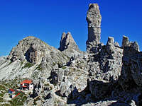
Via Ferrata De Luca-Innerkofler

Via Ferrata De Luca-Innerkofler

Page Type Page Type: Route
Location Lat/Lon: 46.62569°N / 12.31537°E
Additional Information GPX File: Download GPX » View Route on Map
Additional Information Route Type: Via Ferrata
Additional Information Time Required: Less than two hours
Additional Information Difficulty: Up to UIAA II
Sign the Climber's Log

Overview

Rifugio Locatelli (2405m)Looking back from the start of the route to Drei-Zinnenhütte
Paternkofel / Monte Paterno is one of the most popular mountains of the Sexten Dolomites / Dolomiti di Sesto. It's summit can be reached by three vie ferrate of low to moderate difficulty, all of which date back to WW I, when the plateau beneath Drei Zinnen / Tre Cime di Lavaredo was a heavily contested battlefield. The dominating position of Paternkofel / Monte Paterno made it a position of strategic importance. The normal route to the mountain, probably the most difficult of the three vie ferrate, Via De Luca-Innerkofler makes use of a WW I tunnel, which was cut through the north butress of the mountain. It is several hundred metres long, very steep and only very occasionally lighted by an opening in its walls. From the upper end of the tunnel a steep, slanted ledge leads to Gamsscharte, where the other routes join. From there the remainder of the route leads across the brittle steps of the mountains east face. Via De Luca-Innerkofler is a one way affair. Thanks to its popularity it is virtually impossible to use it as descent route. While only moderately difficult its main dangers lie in rockfall induced by other climbers.

Getting There

Handdrawn map of the...Handdrawn map of the Paternkofel / Monte Paterno Group.
The via ferrata starts at Drei-Zinnenhütte / Rifugio Locatelli, which can be most easily reached from the big parking lot near Rifugio Auronzo. The latter can be reached by toll road from Misurina. From Rifugio Auronzo hike to Paternsattel / Passo Lavaredo. Take the broad gravel road which leads to Drei-Zinnenhütte / Rifugio Locatelli.

Route Description

Paternkofel (2744m) in front of Toblinger Knoten (2617m) and Schusterplatte (2957m)Paternkofel above the access road from Paternsattel to Drei-Zinnenhütte
  • General:   - Start altitude: 2452m   - Summit altitude: 2744m   - Prevailing exposure: N, later E   - Type: Ferrata nbsp; - Protection: Well Protected
  • Effort: 400m overall gain
  • Power: 2 - Steep and strenuous
  • Psyche: 3 - Tricky because of scree on the ledges
  • Difficulty: 2 - Easy ferrata
  • Orientation: 3 - Easy, but for the very last section on the summit ledges From Rifugio Auronzo head for the Paternkofel / Monte Paterno North Ridge, which ends almost directly at the hut. Follow the ridge, passing a picturesque rock tower (called Frankfurter Würstel in German). Here you find signs towards the tunnel (galeria) and soon stand in front of its mouth. It makes no sense to enter without a light as the tunnel is long, low and narrow. It also pays to wear a helmet as the roof comes down to less than 2m in several places. The tunnel rises steeply in steps. Shortly before you reach its end an opening to the right hand side offers a view of the Drei Zinnen / Tre Cime Plateau in the west. A few more steps and you exit the tunnel onto a platform on the other (eastern) side.
    On the northern ridge of Paternkofel
    Old military shelter
    View to Toblinger Knoten from...
    The beginning of the ferratea.
    From this platform you have to climb (UIAA I) up a 3m step which is covered with scree and forces you to balance above a 100m drop. Once on top of the drop, the via ferrata starts properly with a protection cable. It guides you towards a slanted ledge / cut running through the Paternkofel / Monte Paterno North Face. It is a very steep cut, which is best climbed on its airy outside. Only shortly before its end the route switches to the safer inside of the cut before descending ino the small saddle of Gamsscharte / Forcella dei Camosci.
    Northern ridge
    In the WW1 tunnels of...
    The ferrata runs up this shelf
    Climbing Monte Paterno
    Here the other routes join: from the east Schartensteig / Sentiero delle Forcelle heads over from Buellelejoch/Forcella Pian di Cengia from the south Passeportensteig heads along a ledge towards the saddle while the regular route heads up a steep couloir from the south-east. A fifth route turns west and heads up a steep section in the west face. After negotiating a 5m shoulder it heads up a 10m chimney to end up on one of the Paternkofel / Monte Paterno ledges.
    Monte Paterno
    On the ferrata to Monte Paterno.7/2005
    Looking back from the shelf towards Drei-Zinnen-Hütte
    Descending from Forcella del Camoscio
    Here orientation gets tricky. There are multiple possible routes to scale the ledges and there are far too many cairns to mark a specific path. Make sure you stay away from the east face of the mountain and head south-west instead. After stepping over several ledges the route (now again visible) turns north-west and heads for the surprisingly broad summit.
    Drei Zinnen (2856m, 2999m, 2973m)
    The short secured rocky passage below the summit.
    The wall at the Forcella del Camoscio
    Großglockner (3798m) above the summit of Langlahnspitze (2770m)
    Descent: Do not use Ferrata De Luca / Innerkofler - it is a one way route. Rather take the southern route towards Paternsattel, which negotiates ledges and tunnels on Passeportenkopf. Use the south-western route only if you are familiar with scree descents. Though it is the only unprotected route it certainly is the most dangerous of all.

    Essential Gear

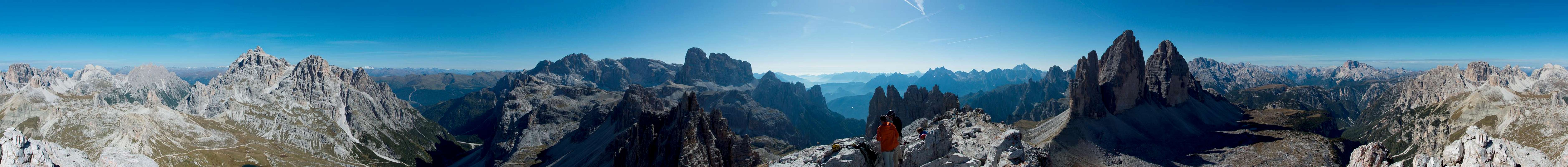
    360° Panorama from Paternkofel / Monte Paterno
    You need a full ferrata set. Besides regular hiking gear you need a harness and a self-belaying system (two biners on Y-shaped rope with braking system). You'll also need a helmet. If you plan to hike one of the other two ferrate bring a torch (better a headlamp) for the galleries.

  • Parents 

    Parents

    Parents refers to a larger category under which an object falls. For example, theAconcagua mountain page has the 'Aconcagua Group' and the 'Seven Summits' asparents and is a parent itself to many routes, photos, and Trip Reports.