
-
 12968 Hits
-
 77.86% Score
-
 9 Votes
|
|
Route |
|---|---|
|
|
44.13720°N / 113.7794°W |
|
|
Steep snow, Ice |
|
|
One to two days |
|
|
AI 3 |
|
|
Approach
Arguably one of the BEST long, moderate snow and ice routes in the state of Idaho. Some have said the North face of Borah Peak is completely out of character with the rest of the range and is reminiscent of the large faces in the Canadian Rockies. With an approach which is not too difficult to follow and beautiful lines to the summit, this is a climb every aspiring Idaho mountaineer should add to their "Tic" list.
The approach the North face via the Rock Creek drainage.
To get to the parking spot, continue West past the turnoff to the standard route to the Doublesprings Pass road. Turn right and go about 1/2 mile on Doublesprings Pass road until you reach the end of the fence on the right hand side of the road. Make a right turn onto a dirt double track road heading east. Follow this double track road to the end (approx. 2 miles) at it's end is a wide flat camp spot and an irrigation diversion dam on Rock Creek.
There is one very small creek crossing and a gate to pass through, please leave gate as you find it (if it is open when you go, leave it open--if it is closed, pass through and reclose gate behind you).
Double track dirt road is passable in most vehicles, higher clearance vehicle is preferred, 4 wheel drive isn't needed.
 |  |  |  |
Route Description
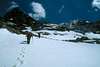
From parking spot along Rock Creek it is approx. 5 miles to the base of the North Face.
Cross Rock Creek at diversion dam and follow Rock Creek drainage on East side of creek. Try and stay about 200 yards above creek to avoid brushy areas as much as possible, after about 1/2 mile there is a faint climbers trail and an old wagon trail which can be followed for most of the approach. After about 3 miles the creek turns Eastward, remain close to the creek for about the next mile to avoid "death scree" to the left and brush to the right. Creek eventually leads to a wooded valley and the North face of mountain is clearly visible from here.
Continue hiking up valley toward N face which ends at cliff bands (elev ~9800 ft). Depending on conditions, either continue up snow gully for approx 200 vertical feet, or scramble through rock ledges to right of gully (class 3+), then continue scrambling to base of N face (elev, ~10,500 ft)
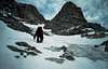
Choose any of 3-4 routes through rock bands on face below summit block.
The most obvious is to the right of the lower rock bands. There is also a very aesthetic, but somewhat hidden line through the center of the lower rock bands. Choose your line and climb for 5-7 pitches over increasingly steeper snow/ice (40-45 degrees), until you reach the base of the summit block.
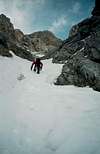
Look up the first obvious couloir (leads to the NF Direct route) but bypass this and traverse under the summit block to the East for 3-4 pitches. Just as you are about to top out over the East ridge, there is a narrow couloir which leads nearly directly to the summit.
The angle in the couloir steepens (about 50-55 degrees ) and is 1 1/2-2 pitches in length. The couloir is generally always ice and will require a belay or simul-climbing to reach the summit ridge. The trail from the SW (chicken out) ridge route passes right where the couloir meets the summit ridge and it is about 50 meters to the summit.
Descend the SW (chicken out) ridge route until you get to the last saddle in the trees before the trail drops to the left to the main parking lot. Cut off the trail to the right here and hike cross country on a compass heading of ~350 degrees to keep from getting sucked into one of the drainages feeding Rock Creek. All the drainages eventually lead back to Rock Creek, but they could add about 2-3 miles and substantial bushwacking to get back to your vehicle!!
 |  |  |  |  |
Essential Gear
60 meter rope, helmet, crampons, 2 ice axes, 2-3 snow pickets, 4-6 extra biners (preferrably locking), 6-8 medium ice screws, 4-6 quick draws, 6-8 various slings/cordellette
Miscellaneous Info
This route can be done either as a long day (10-16 hours) "alpine" style by fit experienced climbers or as an overnight trip.
The alpine style trip being the preferred style as anything you take up Rock creek has to be carried over the top of the mountain.
If you choose to do this as an overnight trip, there are good bivy/campsites on the morraine fields below the N face, with water usually available by melting snow, or sometimes found running off nearby cliffs.
If you do not want to carry bivy/camping gear over the summit you may also opt to return through rock creek, but the downclimb along the NE ridge, or reversing your route back down the N face is generally harder (multiple rappels/steep down climbing) and usually takes about as long as descending the SW (chicken out ) ridge route, but with much more effort.
If you want a last minute "scouting" report on general conditions of the N face, continue travelling on highway past Doublesprings Pass road toward Challis for about 5-6 miles. There is a turnout on the left (south) side of the road which you can park and see most of upper North face fairly well with binoculars.