Brad's Outdoor Adventures
Mount Yale (14,042 feet), “Mascot Peak” (13,435 feet)
Class 2 with some bushwhacking
Distance (round-trip): abt 10 miles
Elevation Gain: abt 4,600 feet
Introduction: I had heard that you can see 30 other 14ers from the summit of Mount Yale, and that alone was enough reason for me to do this hike. On top of that I wanted to try another mountain in the Sawatch Range, as I was drawn to its beauty and pristine-ness.
5:34- I started up the Colorado Trail from the Avalanche Gulch Trailhead. This was my first time on the Colorado Trail, and my first time entering the Collegiate Peaks Wilderness. I walked through a very pretty area covered with wild-flowers, aspens, and a couple small rivulets of water. After this I had to ascend a large grassy hill, with an abundance of rather steep switch-backs which helped me quickly gain 800 feet. The climb was barely beginning at this point, however.
Re-entering the tree-line at the ‘top’ of the hill, I continued uphill on the steep but well-maintained Colorado Trail, crossing to and fro over a series of small spurs and draws. It was a pleasant hike through a heavily-timbered conifer forest. I could see evidence of a fire some time ago, however, that charred many of the trees in the area. Also the ground was littered with dead trunks which had been. . . downed in an avalanche, perhaps?
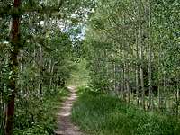
![]()
Scenery: Looking up toward "Mascot Peak"
And on it went, for three and a half miles total, till I reached a saddle at timberline, at 11,900 feet in elevation. There was a tent here, with evidence of occupants but nobody stirring.
7:28- At the saddle, I turned left (west) onto the trail leading to Mount Yale. This is where the hike got a little more interesting.
Mount Princeton (to the southwest) was immense and amazing to view as I walked along the east ridge leading to twin 13,420-foot summits. This trail ascended slowly across a large green saddle, with good views to the north and south. Looking back toward the west I could see a hiker in the distance descending the ridge from Point 12,505. I assume that person was a resident of the tent I saw on the saddle, but I would not see the hiker again.
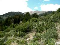
![]()
View of Mount Princeton from Yale's East Ridge
As I continued uphill, the trail became steeper and it seemed the farther I went, the less I felt like I was getting anywhere. The ridge-line kept interchanging between steep, rocky, rough areas and shallow, green “mini saddles,” and I was constantly gaining more and more elevation.
9:06- I got my first real view of Yale as I rounded the pair of 13,420-foot summits. I went down over some more rocks to the next broad green saddle, then started up some more rocks toward the summit of Mount Yale. Many more rocks, in fact.
This climb was pretty much a continuation of what I had been doing since leaving the Colorado Trail. However, I had to traverse a few steep ‘false summits’ before the actual top of Mount Yale came into view. By then it was just a ‘hop skip and a jump’ away.
10:10- I crested the summit of Mount Yale, at 14,196 feet. The view was indeed spectacular, but something that also impressed me was how wonderful the weather was at the summit! It was sunny and warm, with not even a breath of wind! It felt great to just sit there and soak in the scenery.
The solitude was also nice, but it lasted literally only about two minutes before I saw the first hiker cresting the hill to my west. He had come up via the standard southwest slopes route from Denny Gulch Trailhead. Behind him were dozens of other hikers, who began reaching the summit shortly after he came to meet me.
10:42- I had taken my fill of pictures and seen my fill of people, and was ready to leave the summit. However, not wanting my hike to quite be over, I decided to descend the south slopes of Yale and make my way to the impressive-looking ridge of “Mascot Peak.” This descent was a lot further than I anticipated, and it was down rough, steep and slippery scree most of the way to the saddle between Yale and Mascot.
The ridge of Mascot Peak provides an interesting and worthwhile, though often-overlooked climb. It is not a hard climb, but there are an array of natural and scenic towers and steep slopes of rock surrounding you on this fun climb. I much enjoyed it.
11:33- I reached the 13,435-foot summit of “Mascot Peak,” where I had impressive views of both Mount Princeton, to the southeast, and Mount Yale, right in front of me to the north. I sat there to rest and take some pictures for about 15 minutes, and then I had the task of finding my way out.
Not feeling at all like ascending Mount Yale’s steep and daunting south slopes, I decided instead to head downhill after returning to the saddle. Roach recommended this as an alternative route, so I expected there would be a trail in Avalanche Gulch that I could follow. At least a faint trail! However, there was not. Instead I was first greeted by a very steep slope that I had to basically slide down till I got to a point where the ground evened out a bit more. Here there were large boulders lying around, and below them I came into a large area of shrubbery that I had a bit of trouble finding an easy way through.
Finally I headed into the timber, where I followed game trails and tiny streams of water to avoid the large dead-falls lying around everywhere. Eventually I came into more open forest, and just continued walking due east. I started to get to some more hilly terrain and wondered if maybe I was getting off-track.
1:24- Just as I was about to reach in my pack for my GPS, a crevice in the hill in front of me caught my eye, and upon closer inspection I realized it was indeed the Colorado Trail! I hurried over to it, completing my ‘loop,’ and then followed it steeply downhill the rest of the way out to my jeep.
2:06- The air was very hot as I made it back to my jeep. I was about as exhausted as I have felt on any hike recently, but content in that I had met my day’s goals. Now for the drive home. . .
Conclusion: Gerry Roach marks this hike as one of his “classic”s. He lauds it especially for its solitude, which I can definitely echo after having the trail all to myself on a Saturday in mid-July! Granted, this route up Mount Yale is a good bit longer than it’s standard southwest route, but I’m sure it was no less scenic! That, after all, is why I go hiking in the first place: to enjoy God’s Great Outdoors, and the solitude that comes with it!
Comments
No comments posted yet.