
|
|
Area/Range |
|---|---|
|
|
47.46840°N / 120.813°W |
|
|
Hiking, Mountaineering, Trad Climbing |
|
|
Spring, Summer, Fall, Winter |
|
|
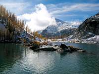
Fall is an amazing time, maybe the best season of all.
Top trip report of 2011 is this picture packed gem. Click HereHere's another gem
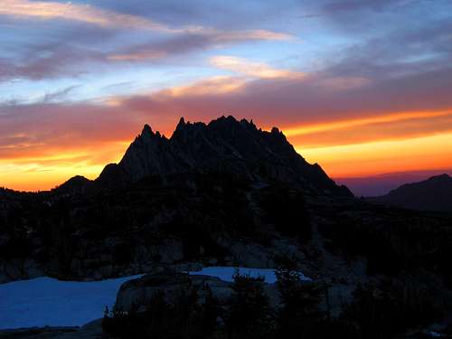 BCJ's pic of the week
When autumn hits the high country, the green of the Alpine Larch trees turn to gold. Here are a couple trip reports with some outstanding pictures of this amazing time as presented at NWHikers.net The most recent report is from October 19th and is chuck full of pics as well as being very entertaining.
Check this first TR out HERE.The second TR, is one linked to below and I have featured one as a signature picture. For more from this TR, go HERE.
A video trip into the Enchantments with the first two days in fall weather and the third in winter weather. Check it out HERE.
 This pic by Matt Burton was another pic of the week.
TRIP REPORT worth checking out:
GREAT PICS/STORY
SEE MANY MORE TRIP REPORTS IN SECTION DOWN THIS PAGE
How the Enchantments got their name
The Enchantments, refers to the overall area and is not a name of a mountain range. See the section about Peg and Bill Stark for more on the name. (Section 12)
A.H. Sylvester who explored the area for the forest service in the early part of the 20th century wrote the following after one of his explorations
"I found 5 or 6 most beautiful small lakes grouped in a wonderful glacial valley all ringed with alpine larch. From the highest lake over an entrancing fall tumbled the water it received from a small glacier. It was an entrancing scene. I named the group 'Enchantment Lakes'."
A work in progress
Always a work in progress, additions are still being made frequently. This page will probably always be updated on almost a frequent basis as this area is my "Holy Grail". I have no lock on the area and lovingly share it with you even though the majority of readers will probably never be able to visit this amazing area. My friend Bob Bolton refers to me as "Mr. Enchantment" and that has nothing to do with my personality, it has everything to do with my passion for this section of Washington State.The Enchantment area of Washington State is one of those amazing places that really can make a lasting impression thanks to the beauty you find there. I have been an "Enchantment addict" for the past 40 years and I have been into the area over 30 times. I view putting up a decent representation of this area, no easy task and that is why this page will continue to evolve. I have a lot of information already on the overall area placed on the pages I have put up for McClellan, Enchantment, Little Annapurna and Cannon Peak pages. Others have made additional contribution on pages they have put up (see list at the left). Now I will try and put the whole enchilada together in such a way as to make a visit to this area something you will have to do, at least once in your lifetime. Forget Hawaii, forget Paris or some other famous place, in my opinion, I'd rather spend my free time in the best place of all, "The Enchantments"
Update: From NWHikers - Terrific recent trip report 2015
Getting There
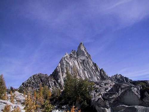 Prusik Peak, an Enchantment centerpiece
From Seattle there are two routes you could take. First, you can get on I-90 and head east over Snoqualmie Pass to Cle Elum, taking the exit to Wenatchee & Blewett Pass via 970 and then US highway 97. Highway 97 takes you over Blewett pass to a junction with U.S. 2. Turn left towards Leavenworth. Go through Leavenworth (you pass the Leavenworth ranger station on this road) until you come to the last road before you start to enter Tumwater canyon and turn left on Icicle road, going 4 miles until you come to the Snow Creek Trailhead parking area, very obvious on the left. Northwest Forest Service pass required.
The 2nd way to get to the same Icicle Creek TH from Seattle or Everett area is to take US 2 over Steven's Pass to Leavenworth. When you come out of the canyon, turn right on the Icicle Creek road and drive as before.
To access the Ingalls Creek Trailhead, you go to near milepost 178 on the Blewett Pass highway, #97, watching for the Ingalls Creek road No. 7312. You turn west across a bridge and then stay left until you come to the trail head in about one mile.
Trailheads & Routes
SNOW CREEK THFrom Highway U.S. 2 on the west end of Leavenworth (turn south on Icicle Road until you start going into the canyon as the road curves to the west, going 4 miles until you come to the Snow Creek Trailhead parking area, very obvious on the left. This TH is right next to the road and requires a NW Forest permit to park there. Also be sure to leave no valuables in your vehicle as this parking area has been the victim of many car burglaries. This trailhead will take you up a hot and dusty trail in the summer but it is the quickest way to the Snow Creek Wall and Nada Lake as well as Snow Lakes. It is ten miles and 6000 feet of elevation gain to reach the Enchantments via this route.
8 Mile Lake TH
For access to Cashmere Mountain, Big 8 mountain, 8 Mile and Caroline Lakes, this is the one you want. It is just a mile before the Stuart Lake/Colchuck TH described below. From Leavenworth, head up Icicle Road about 10 miles to Bridge Creek Campground. Turn left, go past the campground entrance, cross a bridge that spans the Icicle and head approximately 3 miles up a bumpy dirt road to the Eightmile Lake Trailhead. Fee area (NW trailpass)
Stuart Lake/Colchuck Lake TH
If you are interested in the shortest route into the Enchantments, then this is the better of the trailheads to use. Colchuck Lake is a short 4 miles from the TH and the Enchantments another two miles beyond that via the Aasgard route, continue on past the Snow Creek TH parking area until you come to a turn off for Bridge Creek camp ground (left turn only) and FS road #7601, crossing a bridge over the Icicle River and continue onward almost 4 miles until the road ends at the Stuart Lake / Colchuck trail head parking area. Northwest Forest Service pass required. You will pass 8 Mile Campground on the way to Bridge Creek and 8 Mile CG is a good one if you are in need of a place to settle in for the first night and organize gear.
 Full TH parking lot
 Ingalls Creek TH
To access the Ingalls Creek Trailhead, you go to near milepost 178 on the Blewett Pass highway, #97, watching for the Ingalls Creek road No. 7312. You turn west across a bridge and then stay left until you come to the trail head in about one mile. The TH is a small one and often lonely. Again, a NW Forest Permit is required to park here and this lonely TH close to a highway has seen cars broken into on occasion so leave no valuables in your vehicle or in sight.
Ingalls Creek offers backdoor routes into the Enchantments but none are easy or recommended. Perhaps the most well known is the Crystal Creek entry but I decline to offer information for it or for routes via Rat Creek, Toketie or Nada-Temple Canyon. Those routes are off trail and best avoided unless you are very experienced in off trail/cross country travel. The two main routes will remain the Colchuck Lake-Aasgard Pass route and the Snow Creek Trail route.
The Peaks (part of the Stuart Range)
A new summitpost page is being developed for the Stuart Range, check it out HERE.Many of Washington's highest peaks are found in the Enchantment area. I've included
Cashmere and Argonaut Peaks as well since they are close enough to be
counted (by me anyway).
#26 - Dragontail
 Dragontail
Dragontail has several routes up it as you will see on the SP page. Dragontail along with Colchuck Peak form a stunning backdrop to Colchuck Lake and is one of the most beautiful spots in the Cascades.
Here is an interesting Trip Report filed at Cascade Climbers
#33 - Colchuck
 Colchuck
Colchuck is just a stunning peak. The oft climbed glacier route up from Colchuck Lake is the most common route used by most climbers and this peak also has some excellent rock routes as outlined on the Colchuck SP page.
#38 - Cannon Mtn
Cannon Mtn is one of the more unnoticed peaks as it is out of the way although mainly a hike, the last little bit is a nice scramble to a small
spot that has a terrific view.
 Cannon's summit
#52 - Enchantment Peak(s)
A nice hike up from Prusik Pass will bring you close to this one. Here is a TRIP Report on this one. Refer to the SP page for more information and why I've put an 's' on the name.
#57 - Cashmere
Cashmere Peak is considered by some to be just outside of the Enchantment corridor but since it is so close and such a significant peak, it is fair to group it with the others of the area. The trailhead most commonly used to access this peak is the 8 Mile Lake Trailhead, a mile short of the Colchuck/Stuart Lake Trailhead. More information on this peak can be found at the SP page for it.
#66 - Argonaut
Another peak that is considered by some to be just outside of the main Enchantment grouping and is a significant peak to the east of mighty Mt. Stuart. However, to approach this peak, one generally travels through the Enchantment permit area and thus the reason for inclusion. Here is a TRIP report on this peak and approach. For more information on this exciting peak, see the SP page linked here.
#70 - Little Annapurna
A non technical peak and probably the most climbed peak in the whole area, Little Annapurna is one of the centerpieces of the Enchantment area. Almost all pictures of the area include it and you'd be well served to just check out all the pics hosted at the SP page.
 Little Annapurna as seen from Gnome Tarn
#88 - McClellan
One of the least climbed peaks in the Enchantment area but the best viewpoint in my opinion of all the peaks, including Little Annapurna.
Again, another very photographed peak, particularly with Leprachaun Lake in the foreground or might Rune Lake. Here is a TRIP report on getting to the peak. Want another TRIP report that is about going up from Ingalls Creek to the peak, then CLICK HERE. Lots of pictures to view at the SP page.
Prusik Peak
One of the most photographed peaks in Washington State, next perhaps to Mt. Rainier and Mt. Shuksan. However, to get pictures of this peak as well to climb it, you have to earn just getting to the base by hiking in from either of the two main trailheads. See the SP page for tons of great pics and route information. Check out the neat animated pic at the right.
 Climbing the crux
Here is a Trip Report of a one day west ridge ascent from Cascade Clmbrs.
Temple Ridge
You really need to buy Fred Beckey's great guide, Cascade Alpine Guide Vol 1, Columbia River to Steven's Pass.
Temple Ridge is fully covered in Beckey's book and at this time, I will refer you to that excellent resource.
Mount Temple
The Boxtop
An excellent SP page by Eric Sandbo is available to learn more about this one.
MORE
Witches Tower
A great SP page has been created for Witches Tower and I happily refer you to that for more information.
 Witches Tower
WEDGE MTN (June 2007 trip report HERE)
Wedge Mtn
Described in the book "75 Scrambles in Washington" by Peggy Goldman
8 Mile Mountain
More on this one later as this page continues to be developed.
 Flagpole Needles, as seen from the summit of Little Annapurna. Fred Beckey & friends did most of the first ascents in this group.
Rock Climbing in the Little Annapurna area
This is just an idea of what is available in one area. Temple Ridge is another great area but I've copied this section from the Little Annapurna SP. Again, Fred Beckey's Guide is the best resource for info about each of these:Rock climbing in the Little Annapurna area
Immediately below Little Annapurna is an area that Fred Becky gave the name "nightmare needles" Several of the formations in the nightmare needles provide excellent challenges and are unique. The "flagpole" is the most famous of them and is easily visible as you look over the edge south towards the Ingalls Creek side. Other structures worth noting are Pennant Peak, Seal Head, Horizontal spire, Porpoise point and others. These can be approached from near a dry tarn on the Crystal Creek approach (described at the McClellan Peak page) For more details, consult Fred Beckey's "Cascade Alpine Guide" starting on page 271. Here's a listing of what is available:
Nightmare Needles Group:
Cynical Pinnacle 6400 ft
Little Snowpatch 6600
Lizard Wall (above Little Snowpatch)
Fire Spire 6650
Ostrich Head 6700
Nocturne Tower 7200
Three Feathers 7200
Cruel Finger 7100
The Tortoise 7400
Westwind Tower 7400
Fantasia Tower 7876
Crystal Lake Tower 7800
Flagpole Needles:
Pennant Peak 8080
The Flagpole 7900
Seal Head 7650
Horizontal Spire 7700
Porpose Point 7300
Cathay Towers
Both groups of needles are accessed from Crystal Creek, accessed by dropping over the south rim near Crystal Lake.
All are well described in Fred Beckey's Cascade Alpine Guide
(see books at left)
Climbing near McClellan Peak
While McClellan itself is not much more than a scramble, located on its ridge or on its flanks are many worthwhile towers and peaks that are good for short rock climbs. Below is a list of a few of them. Beckey's guide has enough beta to get you going. McClellan Peak is more than just a summit, it is an area and a very worthwhile area at that.
Tulip Towers
The Prong (around 7800 feet / prominent north angled needle on the north side of the Chessman)
The Chessmen (seven towers on west end of ridge)
Window Tower
Orange Tower
Bloody Tower
Glockenspiel Tower
Crystal Lake Tower
Three Feathers
Nocturne Tower
Fire Spire
The Turle
Coney Rock
Cruel finger and many more. Rock climbing on short but often dramatic pitches.
All of these plus a drawing of the location and information on each can be found in Fred Beckey's amazing book
Snow Creek Wall
Snow Creek WallAlthough this area is not actually part of the Enchantments, it is still linked very closely to the Enchantment experience. It is only two miles up from the Snow Creek Trailhead and so is fairly accessible. It has become a very popular area for rock climbing. For much more information on this area,
check out RPC's excellent SP page.
 click for full resolution
The Lakes
It was the lakes that started the stampede of the masses up into the Enchantment area. The lakes are everywhere and can dominate your Enchantment experience, even if you are a die hard peak bagger. I must admit that I can feel fulfilled in this area by just visiting the lakes, as I have done many many times. It may be sacrilege to say, but I can be content to make a trip in and not even bag a peak as the visual impact of the lakes can totally overpower my senses. I even used to carry a fishing rod and spend hours idling away my time in pursuit of a tasty trout dinner.I could tell you where the best spots to fish are, but, I won't. Well,
 My son fishing in Rune Lake
Nada Lake
Nada is a destination lake for many hikers and fisherman and has many nice campsites for Enchantment hikers who get a late start and need a place to camp. It is 5 1/2 miles from the trailhead and sits at an elevation of 5500 feet. The trail to Snow Lakes continues on past Nada on its eastern side.
Snow Lakes (two of them)
After leaving Nada Lake, another mile of trail brings you to Snow Lakes. There are two of them, divided by a small dam that is used to cross between the two. The trail goes around the upper lake on its south side and continues on the south side (for about one mile) until crossing a small bridge over the inlet stream. Good campsites are found around the lake.
Naiad Lake (Temple Lake)

Naiad Lake isn't visited all that often even though it is just a few hundred feet off of the trail that comes up from Snow Lakes.
Lake Viviane
Lake Viviane is truly the gateway lake for the Snow Creek trail entry. Excalibur rock juts out into the lake and it isn't hard to feel the imagery that fueled the Stark's when they put names that portrayed the time of King Arthur and his court.
Leprauchuan Lake
Just after meeting Lake Viviane, the trail makes an interesting climb up to the banks of Leprauchuan Lake, another beauty spot of this part of the Enchantments, often referred to as the 'lower' lakes.
Rune Lake (Perfection Lake)
The biggest lake in the middle Enchantments, Rune Lake is the centerpiece. Pictures taken can include either McClellan Peak, or Prusik Peak or Little Annapurna, depending on what side of the lake you are shooting from. It is also, one of the three lakes with two names. I call it Rune as did the Starks, others call it Perfection Lake, a name I couldn't argue with as it is as close to perfect as a lake can get. Several campsites can be found on the northern side, between Talisman Lake and Rune. Fishing in the 70's was terrific in this lake but today, you'll find little reward for your efforts. Carry a camera, and use it alot as you enjoy this lake. Staying on the east side of Rune Lake, head north to the inlet and then west to get to the next lake, Talisman. A true treat and yes, a true inspiration.
Talisman Lake (Inspiration Lake)
Ah, one of my favorite all time lakes. It is personal, it is alpine, it is a classic. The entry to and from the upper Enchantments is found on the southern end, often up (or down) a steep snowbank that early in the season can go right into the lake. I have camped here many times and I have even seen an otter swimming as it diminishes the fish population. It is a pleasant place to spend some time and camping spots can be found on a knoll above the lake and at the northern end, where the trail comes up from Rune Lake. An alpine potty is located about 100 yards up from the lake and as you while away your time there, you are treated to a wonderful view of Rune Lake.
Crystal Lake
Crystal Lake is also one of my Enchantment favorites. It is almost the same elevation as Rune Lake and is reached by a short side trip from the main trail. Nice views are obtained as one ascends towards Little Annapurna.
Shields Lake
Instead of going west at the inlet to Rune Lake, take the Prusik Pass trail that heads directly up the slope gaining 400 feet of elevation and then drops over to another valley where you lose 700 feet of elevation, the valley containing Shields Lake and Mesa-Earle Lakes. Shields Lake isn't as visited as the main lakes of the Enchantments but it has a charm of its own. Be aware that it can be mosquito hell as well as fisherman heaven.
Campsites can be found near the inlet and on the northern end of the lake.
I'll provide more info about an exit route via Toketie Lake but that will have to wait until later.
Mesa-Earle Lakes
These two little lakes are at the north end of the valley and are best accessed by a use trail found on the east side of Shields Lake.
Toketie Lake
A small lake, very much out of the way and a victim of the 1994 fire that burned the area. The area just above it can be marshy and mosquito breeding grounds but if you are seeking solitude from the masses, this can provide an escape. It is accessed via Shields Lake and gaining Toketie Pass before dropping down to the lake.
Coney Lake
The most isolated of all the Enchantment area lakes and hard to get to. Rarely visited, it has one small campsite and is worth a visit at least once in your lifetime if you go into the Enchantments 20 or 30 times. You can look down on this lake as part of a climb of Cannon Mtn. I approached via cross country from the west shore of Earle Lake.
Brynhild Lake (Isolation Lake)
Brynhild is the largest of the Upper Enchantment Lakes. It is in an area where you are totally above the tree line and with the Witches Tower and Dragontail Peak forming a backdrop, makes you feel like you are in the High Sierras. I have pitched a tent near the lake and experienced the wind, snow and feel that such an experience can provide. It can restore the soul to experience this area in borderline weather. Aasgard Pass is not far from this lake and since probably the majority of visitors to this moonlike landscape come in this route, Brynhild is the first major lake that they see.
Other Upper Enchantments Lakes: See the map below of the Starks for
their locations. A couple are off the beaten track but all can be seen
as you make your way through this somewhat barren appearing landscape.
Freya Lake
Reginald Lake
Ladgann Lake
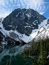
Colchuck Lake
This lake deserves more than just a mention so more will be forthcoming as I continue to develop this "Lake" section.
Stuart Lake
A separate trail goes to this one and this is worth a visit sometime during your Enchantment career. Amazing views of Stuart's north face await
Horseshoe Lake
A faint trail leads to this lake from Stuart Lake and tiny Jack Lake is nearby. These two lakes are for those who are "lake-a-holics".
8 Mile Lake
A destination lake in its own right, a large subalpine lake that attracts tons of people on the weekends in nice weather. Avoid this beauty spot except for a looksee or if you have interest in 8 Mile Mountain.
Little 8 mile lake is found near the trail junction that leads up to Caroline Lake and makes a good rest stop. Oh yes, some decent camp spots at 8 Mile Lake.
 8 Mile Lake and 8 Mile Mtn
Lake Caroline
A pretty lake after an endless climb of switchbacks in a burned area. This lake and Little Caroline Lake are often used as basecamps for Cashmere Mountain.
plus many more small lakes, lakelets, ponds and .....
Three of the above lakes have two names. The ones in brackets are the Forest Service names. More about that in the section on Bill and Peg Stark
(Note: Information on each lake will be forthcoming)
Here's a sample of a couple of my favorites
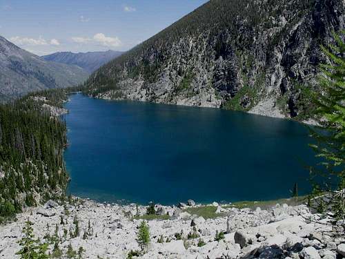 Colchuck Lake as seen from the flanks of Colchuck Peak
Colchuck Lake as seen from the flanks of Colchuck Peak]
Leprechaun Lake is another beauty spot as this special shot by Matt Burton shows in mid October.
 Leprechaun Lake
Stay tuned for an organized listing of the lakes in the Enchantment area and there are a lot of them, a treasure chest of them.
The Golden Week

One of the best articles on the Alpine Larch, noteworthy in the Enchantment area was written by Greg Johnston in the Seattle P-I on 10-17-02. Read the whole article as it is chuck full of great information but here is a few excerpts from that article:
 Golden Larch line the shoreline of Talisman Lake
"The larch is one of only two deciduous conifers in North America. It has needles on what look like typical evergreen trunks and branches, but like a leafy tree, it drops its needles in the fall. One of two larch species in Washington, the alpine larch (Larix lyallii) grows as high in the mountains as any other tree, often in the most inhospitable, rocky spots in north-facing basins buried by snow much of the year."
"But the larch's most spectacular attribute is the brilliant yellow-gold it turns in fall, at times almost illuminated when hit by the angled autumn sun, a stunning harbinger of impending winter to hikers and other mountain travelers."
"You get that blue sky and golden larch, throw in a little new snow and bright red huckleberry leaves, and that is a hard scene to beat," says Gary Paull, a U.S. Forest Service trails coordinator who has studied the larch. "It's a unique tree in that it drops its needles in fall and turns this incredible color right before it does."
"The alpine spectacle that larches create in October is so compelling that many hikers plan annual trips to trails known for the trees. The most popular are those in the Enchantment Lakes basin southwest of Leavenworth in the Alpine Lakes Wilderness."
"They're just pretty. Everybody who sees them at this stage just falls in love," says Alan Yen, a member of the Washington Native Plant Society who once took an 18-mile day hike through the Enchantments to see the trees. "The Enchantments, once you get into the upper basin, all you have is larches and rock. It's amazing if you hit it at the right time. "
----------------------------------------------------------
That right time I like to call THE GOLDEN WEEK. Sometimes it is in mid October, other times the last week of September or first week of October.
It is my favorite time of the year in the Enchantments
(see pic at left HERE)
 Bill & Peg Stark map
-----------------------------------------------------------
The 2006 larch season is over but check out the below Trip reports posted
at NWHikers.net, a tremendous web site that has tons of great trip reports and information pertinent to the northwest. In fact, here is another outstanding trip report with pics.
A Trip Report with wonderful Larch pics can be found HERE. The pics will blow you away.
Yet another report and pics. Click HERE
And check out one of the pics in the following report:
From this recent account the larch trees are starting to turn.
Also check out this TR has some pics showing the larch trees turning. From a dayhike effort.
Here is a NWHikers trip report that has some wonderful pictures of what is my favorite season in the Enchantments
Please click on this link to a new resource for why October is my favorite time in the Enchantments. StephAberg has done an outstanding job.
History anyone?
The guy who really pioneered tons of stuff in the Enchantment area was none other than Fred Beckey. His book, Challenges of the North Cascades details many of his early efforts in this area.Also, his Cascade Alpine Guide vol 1, is a valuable resource for climbing in this area.
FRED BECKEY
One of America's most prolific climbers, Fred Beckey is still climbing in his mid 80's. Not only an incredible climber, he is also an author of the famous Cascade Guides and several other books. Fred discovered the Enchantment area in May of 1947. Along with some friends, he headed up the Snow Creek trail to begin a relationship with the rock of the area that is well described in chapter 11 of his book, "Challenge of the North Cascades" . Fred pioneered climb after climb in the area and for the next several years made visit after visit into the area to make new routes and first ascents.
Bill and Peg Stark
Perhaps no one made the Enchantments so "Enchanting" as this couple. Karen Sykes made these comments about the Stark's in an article she wrote for the Seattle P-I in 1998. If I may, let me quote her on the Starks:
"When they made their first visit in the fall of 1959, they were captivated by the golden splendor of the larch trees, the numerous lakes and tarns, and jagged peaks towering above. They used fairy names -- Gnome Tarn, Troll Sink, Naiad Lake, Sprite -- and King Arthur legends in the Lower Enchantment Basin because "the lower basin was not as austere as the upper basin," according to Peg.
"They used Norse names and mythology for features of the upper basin -- Brynhild Lake, Lake Freya, Valhalla Cirque -- because, Peg told me recently, it felt "as if the Ice Age had just gone off."
They made a map up for the area and it became the "bible" for those of us who ventured into the Enchantments during the 60's and 70's. I received a copy personally from them as I met them on my second visit to the area in 1971. A copy is viewable by clicking on the thumbnail just below this information. Then for the next twenty years, most people used the Stark's names for Temple (Naiad), Perfection (Rune) and Inspiration (Talisman) Lakes, names that the forest service used. Today, most people are using the forest service names for those three lakes but the remainder of the nomenclature created by the Stark's remains. The Starks are now in their 90's but continued their treks into the Enchantments until they were into their 80's. Just a few years back, I met them again as they walked in Leavenworth, still healthy and full of life. They produced a VHS presentation called "How Deep the High Journey" which is chock full of their pics presented as a slide presentation and Peg's narration.

Red Tape - The Enchantment nemesis
LATEST ON PERMIT SETUP: LINKIf you clicked on the above link, you will notice that the application process is now Feb 1st to the 8th. They moved the deadline up a month
so most likely you will not be in the loop for 2010 if you weren't aware of
that change.
In 1984, I was camping in the upper Enchantments over a labor day weekend and there were people everywhere. Tents dotted the hillside and it was even worse in the Enchantment Lakes lower down. People were loving this place to death. This did not pass unnoticed by the powers that be and within a couple of years, the Forest Service implemented a permit system to control the "crowds". Personally I hated this infringement but in reality, it was probably the only choice. So today, in order to overnight in the Enchantments between June 15th and October 15th, you have to get a permit from the Leavenworth Ranger station. Currently the charge is 3 bucks a day which includes the day you go in as well as the day you come out. 75% of the permits are given out by mail and 25% are given out each day during the season. As far as getting reservation permits by mail, you need to be on top of this as many of the permits are gone shortly after the first week that they are accepted by the Leavenworth Ranger station on March 1st. I'll list the address below. The 25% given out daily are given out at the Leavenworth Ranger station in Leavenworth at 7:45 A.M. If more people than permits that are available show up, then the ranger does a "lottery"
There are five spots available for the Enchantment Lakes area and one available at nearby Snow Lakes and one at Colchuck Lake. Not alot but if it is the middle of the week, you have a good chance of getting in. Weekends are much tougher. I personally have had about a 50 percent chance of success for the Enchantments during the weekday however, the FS only allows you to get one permit trip per season in. Hmmm, you still have the ability to go before June 15th or after October 15th. The latter date is right about the time that the larch trees turn gold and is one of my favorite times to be in this area. In 2002 we had a great extended season and it was still possible to access this whole region with no problems.
At the Trailheads, (Snow Creek, Lake Stuart and Ingalls Creek)
you need to display a Northwest Forest Service Pass or risk being ticketed. Holders of Enchantment permits are given parking passes to display during their allotted time but that is a dead giveaway on how long you will be leaving your vehicle. Break-ins have occurred at both the main trailheads with the Snow Creek TH the one most hit most often.
For more information:
Wenatchee River Ranger District
600 Sherbourne
Leavenworth, WA 98826
509-548-2550
One final note: U.S. backcountry forest rangers regularly patrol the Enchantment area and the main trails and if you encounter one of these rangers you will find them friendly and helpful but they will ALWAYS ask to see your permit. In the past six years, I've been stopped and checked three times. If you use the Ingalls Creek trailhead, fill out one of the free permits available at this trailhead and if stopped by a ranger in the Enchantment area, let them know you are camping in the Ingalls Creek zone. I will try and post a map that accurately shows the Enchantment fee area so you will know where to camp just outside of the boundary and be safe from being fined.
-------------------------------------------------------
Enchantment Lakes Traverse
From trailhead to trailhead, this has been growing in popularity. When Backpacker Magazine's May 2005 Issue hit the stands, it had a list of America's ten toughest dayhikes. Well, it is a debatable subject and many tough dayhikes were not listed but the Enchantment Lakes Traverse came in at #8. This article will most likely bring many more people to the traverse now that it has been publicized in a national magazine but it is worthy of the attention IMO. It is 17 miles from trailhead to trailhead with most people going in from the Colchuck / Stuart TH as this offers less elevation gain and eliminates going down from Aasgard Pass when you are stating to get tired. So, if you have the desire and want a quick look at the Enchantment area, this one is a good sampler. See my trip report of my experience. I'm planning on doing it again this year.Trip Reports / Links / and more info coming
Are you a runner? Here's a report by a guy who is. Not my way of seeingthe "Chants" but an impressive effort.
Trailrunning the Enchantments (from NWHikers)
NWHikers member soccer_dad put up this outstanding trip report
that is worth checking out as it is full of very nice pics and represents
the initial Enchantment experience extremely well.
Another great TR from the Enchantments (thanks to NWHikers) is full of great
pics. See it HERE.
SP memberAndy Dewey posted a trip report on NWHikers that I'd like to share. Click HERE to bring up this picture filled report and get a feel of the Enchantments in early June.
Be sure to check out this picture filled trip report on a climb of Colchuck
Peak and an attempt on nearby Cashmere Peak.
That report can be found HERE
Brian Jenkins
2DrX trip
Jeff Olson's 1996 trip report
Colchuck Peak climb with pics
From Cascade Climbers come some recent trip reports that highlight trips into the area for climbing or fun:
Dragontail Peak - Triple Colouirs
Dragontail Peak - Skiing down the Triple Colouirs.
Temple Ridge excursion
Snow Creek Wall
Temple Ridge area climb:
LINK TEXT HERE
From NWHikers.net comes this nice
TR
Older Trip reports:
Dragontail, Colchuck and Witches Tower
General Thread on the Enchantments
Labor Day trip with my son in law
From Colchuck to Upper Enchantments
Mt. Temple Accident
Some great pics of goats in this TR
McClellan Peak's register story. An interesting read.
Colchuck Peak
THE LATEST ENCHANTMENT TRIP REPORT? RIGHT HERE
NWHikers has several threads posted about the Enchantments right now.
Check them all out.
Aasgard Pass route as approximated on this photo
 Aasgard route and north wall
More Trip reports from 2007
Colchuck Peak climb
May 28th Trip Report This one will clue you in on Aasgard conditions as reported by our own Tazz
May 19th
New Trip report - Edward Mesa via Hook Creek. Check it out.
CHECK OUT Z-Man's Route addition on Dragontails Triple C's.
Excellent Trip report with pics of some Enchantment summits from the south side. Check it out HERE.
More maps
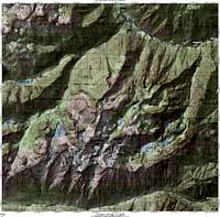 High quality topo of full area.
 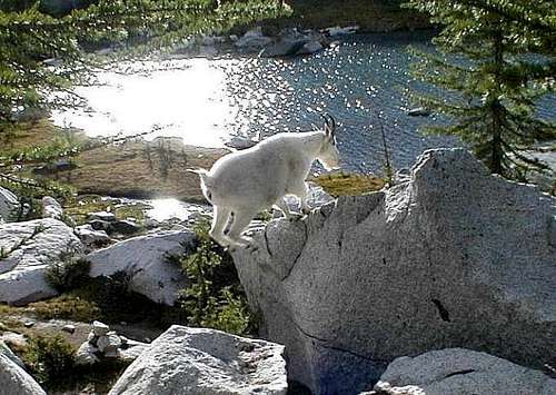 Keep your camera ready
The mountain goats
Almost everyone who spends any time in the Enchantments will see mountain goats. They provide great photo op's for the shutterbug but it is important to remember that these are wild animals and a safe distance should be maintained at all times. They are interested in humans for the salt content of our urine so when relieving yourself, make sure to do so on rocky areas, not on fragile tundra / meadows as the goats will tear up the soil in their pursuit of the salt.[img:14116:alignleft:medium:Keep your camera ready]
For a lot of really nice goat pictures, NWHiker's Tom Davenport has a bunch on this NWHiker's thread (click here) and then scroll down about halfway to see his pics.
Mountain Lions / Bears in the Enchantment area
While I have never seen either a lion or a bear in the Enchantment area, there have been reports of sightings by others. I used to hear stories about a bear that lived near Nada Lake but I no know one who personally saw this bear. Another bear was supposedly seen in the Stuart Lake area and again I've had no confirmation of this.Mountain lions may be around but I've never even seen a track in all the times I've been in and out of the area. I picked this up off of the Pacific Crest Trail List today (1-29-07) and had heard the story before by Jeff but here it is again:
Message: 8
Date: Sun, 28 Jan 2007 15:11:46 -0700
From: Jeffrey Olson
Subject: Re: [pct-l] mountain lions
Cc: pct-l@backcountry.net
While hiking in the Enchantments in Washington I pitched my ground
cloth
on sand. I woke up in the morning, and stretching and such, looked
down
to see two cougar prints about a foot from where my head had been
lying. I just imagine it leaning over to smell me. I have a picture
to
prove it! Curious indeed!!!
Jeff, just Jeff...
Jeff reported to me that it was on the Colchuck side of Aasgard Pass, about 400 vertical feet from the pass itself.
If anyone has a story to tell, please let me know.
Trip Reports & NWHikers.net
SP member Spotly's climb of Prusik Peak.LATEST TRIP REPORTS
June 2009
June 2009 - another one
How about a NOVEMBER backpack trip? Yes, November.
Click HERE
Check out this Trip Report of an Oct 13th dayhike traverse of the Enchantments: The pic to the left is from that trip report
The second trip report from that traverse was posted by Matt Burton. His pics, like the ones in the previous report are outstanding.
See them here
Larch season is about done but here is a TR that shows some nice larch pics from a recent hike up to Colchuck Lake:
REPORT HERE
Another recent October report showing conditions in Upper Enchantments:
CLICK HERE
Another good report from late September:
CLICK HERE
NWHikers.net has become in my opinion, the single best place on the net to find great information and photos & trip reports on this incredible area (the Enchantments).
The members of this group are diverse and are hikers, climbers, lake lovers, photographers and outdoors people. Many members are key in helping to try and protect the northwest and this group is also very social and funloving. Spend some time with this valuable resource and you'll see what I mean, it is the best place to go if you want information on northwest hikes, climbs and outdoors. The photography alone is stellar as there are so many very talented people who share their photos. I have used many on this page and particularly appreciate the generous use of photos by Tom Davenport, one of the founders of nwhikers, and Matt Burton, an outstanding photographer and climber. I have
recently added several of their pics depicting the Golden Larch trees found in the Enchantments.
One other note is that many of our fellow SP members are also members of nwhikers.
mandrake - Jul 6, 2011 2:57 am - Hasn't voted
Aasgard PassIt may be worth noting that if Aasgard Pass is snowbound it can be a very different experience and may require ice axe, crampons and possibly even a rope for safety. There have been a number of accidents and fatalities - often climber's right of the "tree island" (i.e. the south side of the pass). The snowfield on that side may offer a shorter and more direct line to the top - although the terrain is steeper and, during spring melt, the solid-appearing snowfields can quickly become undermined by running water. There may be little to no indication of when this transition occurs. Accidents have occurred here with individuals falling or glissading into open moats and crevasses generated by warming rocks and running water. Staying to the climber's route - specifically to climber's left of the "tree island" - may be adviseable for safety.