The page was successfully edited.

-
 116894 Hits
-
 98.17% Score
-
 78 Votes
|
|
Area/Range |
|---|---|
|
|
37.09390°N / 118.522°W |
|
|
Hiking, Mountaineering, Trad Climbing, Toprope, Bouldering, Ice Climbing, Mixed, Scrambling, Skiing |
|
|
Spring, Summer, Fall, Winter |
|
|
14242 ft / 4341 m |
|
|
Overview
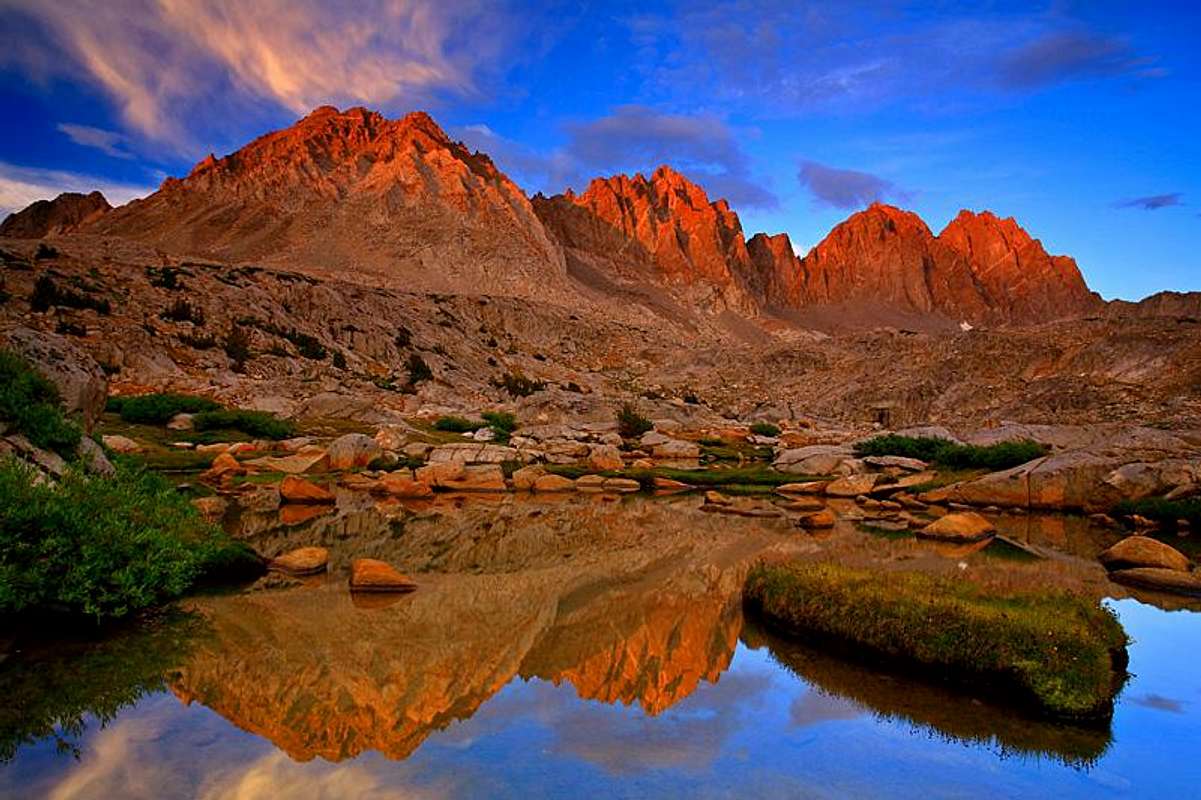
The Palisades. Photo: Misha
The Palisades is the most alpine subrange in the Sierra Nevada and contains some of the Sierra's highest peaks, its largest glacier, and most stunning scenery. It is a Mecca for trad climbers, ice climbers, backpackers, and a few scramblers who seek the area's dramatic scenery and alpine adventures.
The Palisades includes seven mountains topping 14,000 ft., which is nearly half of the 14ers in California, and several other peaks that are over 13,000 ft. The Palisades' high point is North Palisade at 14,242 ft. The Palisades spans from Taboose Pass south of Cardinal Mountain to Bishop Pass north of Mount Agassiz. It straddles the Sierra Crest and is bounded by the John Muir Wilderness in Inyo National Forest to the east and Kings Canyon National Park and the Middle Fork of the Kings Canyon to the west. Much of the west side of the range is only accessible by cross-country hiking. The most common type of rock is granite of varying quality, although metamorphic "Roof Pendants" seen at the top of Split Mountain are also present.
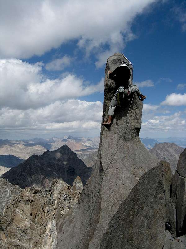
"Starlight Peak" - Photo: m_dquist
Most of the routes in the Palisades are at least somewhat difficult. The Palisades include several classic alpine rock, and snow, ice-climbing routes. It is also possible to do a traverse of most of the major Palisade peaks. However, because the Palisades peaks as a group are steep--much steeper than most other Sierra Peaks or subranges--there are only a handful of established class 2-3 routes. In fact, several summits--Polemonium Peak, North Palisade, "Starlight Peak", and Thunderbolt Peak can only be reached by at least fourth class climbing and Thunderbolt Peak's summit block is Class 5.8-5.9.
Besides rock, the Palisades also contains some of the Sierra best snow and ice climbs. The East Couloir of Split Mountain, V Notch Couloir of Polemonium Peak, and U-Notch Couloir between Polemonium Peak and North Palisade contain snow climbs early in the season and ice climbs in the fall.
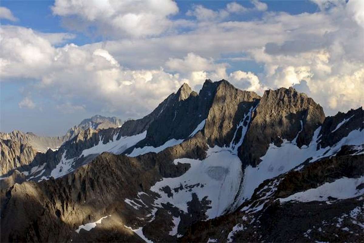
Norman Clyde Peak. Photo: Misha
The Palisades also contain some fantastic backpacking opportunities. Much of the west side of the Palisades and basins immediately below are accessible only after climbing over class 2 and class 3 passes, although the Basins between the passes are gentle, rolling granite landscapes. Two trails, the Bishop Pass Trail and Taboose Pass Trail, cross the Sierra crest adjacent to the Palisades along with a few cross country routes, none of which are trivial. The John Muir Trail/Pacific Crest Trail parallels the Palisades to the west below. Steve Roper's "Sierra High Route" also passes through the area, offering a more adventurous and alpine alternative to the John Muir Trail below. A few trails approach the east side. The Big Pine Creek Trailhead provides access to some of the finest scenery in the Sierra, with views of the east side of the Palisades from Disappointment Peak to Mt. Agassiz, in addition to the Middle Palisade and Palisade Glaciers. The "Camping" section below describes some of the area's camping locations. See RJ Secor's The High Sierra: Peaks, Passes, and Trails for more information.
Etymology
Peter Browning in Place Names of the Sierra Nevada says this about the Palisades' etymology:
"The Palisades were named by the Brewer party of the Whitney Survey in 1864. '...along the Main crest of the Sierra is a range of peaks, from 13,500 to 14,000 feet high, which we called "the Palisades." ...they were very grand and fantastic in shape."
Routes
Peaks listed are found in The Climber's Guide to the High Sierra and are listed from south to north. Summitpost links are provided for the peaks when available. When not available, Lists of John links are provided.| Peak | Elevation | Route | Rating |
| 12851 | 12,851 ft. | From Taboose Pass | Class 2 |
| Cardinal Mountain | 13,397 ft. | Direct East Ridge | Class 2 |
| Split Mountain | 14,058 ft. | North Slope from the East | Class 2 |
| rere | rere | East Couloir | Class 3-4 or AI 2 |
| rere | rere | St. Jean's Couloir | Class 3-4 |
| Mount Tinemaha | 12,519 ft. | South Drainage from the East | Class 2 |
| "Twin Peaks" | 13,061 ft. | From Mather Pass | Class 2 |
| Mount Prater | 13,471 ft. | South Slope from the East | Class 2 |
| Mount Bolton Brown | 13,538 ft. | South Ridge | Class 3 |
| Birch Mountain | 13,665 ft. | South Slopes | Class 2 |
| "Ed Lane Peak" | 13,576 ft. | From Birch Lake | Class 3 |
| The Thumb | 13,388 ft. | Southfork Pass | Class 3 |
| Disappointment Peak | 13,917 ft. | East Ridge / Traverse from Balcony Peak | Class 4 |
| Middle Palisade | 14,040 ft. | Northeast Face | Class 3 |
| rere | rere | Traverse from Disappointment | Class 4 |
| Norman Clyde Peak | 13,920 ft. | North - Northeast Ridge | Class 3-4 |
| rere | rere | Eagle Face | Grade II; Class 5.4 |
| Palisade Crest | 13,553 ft. | Northwest Ridge | Grade III; Class 4 |
| Giraud Peak | 12,608 ft. | Northeast Ridge | Class 3-4 |
| Mount Jepson | 13,390 ft. | From the South | Class 2 |
| Columbine Peak | 12,652 ft. | Death Dihedral | Class 5.10 |
| rere | rere | Northeast Ridge | Class 2-3 |
| "Barrett Peak" | 13,962 ft. | From the north or east | Class 2-3 |
| Mount Sill | 14,153 ft. | Southwest slope | Class 2 |
| rere | rere | Scimitar Pass to Southwest Chutes | Class 2-3 |
| rere | rere | Northwest Face | Class 3-4 |
| rere | rere | North Couloir | Class 4 |
| rere | rere | Swiss Arête | Class 5.7 |
| Isosceles Peak | 12,321 ft. | Southeast Ridge | Class 5.4 |
| rere | rere | Southwest Buttress | Grade II; Class 5.6 |
| Polemonium Peak | 14,080 ft. | Traverse from Mt. Sill to S.E. Ridge | Class 3-4 |
| rere | rere | From the U-Notch | Class 4 |
| rere | rere | V Notch Couloir | Grade III; AI2 or WI3 |
| North Palisade | 14,242 ft. | West Chute (U-Notch Southwest Side) | Class 4 |
| rere | rere | Clyde Variation | Class 4 |
| rere | rere | U-Notch + Chimney Variation | Class 5.2 |
| rere | rere | Starlight Buttress | Class 5.5 |
| "Starlight Peak" | 14,200 ft. | Starlight Buttress | Class 5.5 with Class 5.6 Summit Block |
| rere | rere | Traverse from Thunderbolt | Class 5.6, but mostly Class 3-4 |
| rere | rere | Northwest Chute | Class 4 with Class 5.6 Summit Block |
| Thunderbolt Peak | 14,003 ft. | Southwest Chute number 1 | Class 3 with Class 5.8-5.9 Summit Block |
| rere | rere | Underhill Couloir, Right-Hand | Class 5.5-5.6 with Class 5.8-5.9 Summit Block |
| rere | rere | North Couloir | Class 4 with Class 5.8-5.9 Summit Block |
| rere | rere | Northeast Couloir | Class 3-4 Rock, Class 4-5 Ice with Class 5.8-5.9 Summit Block |
| rere | rere | Northwest Ridge | Grade III; Class 5.5 with Class 5.8-5.9 Summit Block |
| rere | rere | East Face, Right Side | Class 5.6 with Class 5.8-5.9 Summit Block |
| rere | rere | The Summit Block | Class 5.8-5.9 |
| Kid Mountain | 11,896 ft. | From the north | Class 2 |
| Mount Gayley | 13,510 ft. | Southwest Ridge/Yellow Brick Road | Class 3 |
| rere | rere | South Face | Class 4 |
| rere | rere | Right Face (right side of east face) | Grade II; Class 5.8 |
| Mount Winchell | 13,768 ft. | East Arete | Class 2-3 |
| Temple Crag | 12,999 ft. | North Couloir | Class 4 |
| rere | rere | Contact Pass | Class 5.2 |
| rere | rere | Venusian Blind Arete | Grade III; Class 5.7 |
| rere | rere | Moon Goddess Arete | Grade IV; Class 5.7 |
| rere | rere | Sun Ribbon Arete | Grade IV; Class 5.9 |
| rere | rere | Planaria | Grade V; Class 5.10 |
| rere | rere | Southeast Side via Agassiz Col | Class 2-3 |
| Mount Agassiz | 13,891 ft. | West Slope from Bishop Pass | Class 2-3 |
| Mount Robinson | 12,967 ft. | West Ridge | Class 3-4 |
| Aperture Peak | 13,265 ft. | From Jigsaw Pass | Class 3 |
| Mount Alice | 11,617 ft. | All Directions | Class 2 & 3 |
| Gendarme Peak | 13,241 ft. | From Jigsaw Pass | Class 3 |
| Picture Puzzle | 13,280 ft. | North Slopes | Class 3 |
| Two Eagle Peak | 12,966 ft. | East Ridge | Class 3 |
| Cloudripper | 13,525 ft. | West Chute | Class 3 |
| Chocolate Peak | 11,682 ft. | South Ridge | Class 2 |
| "Vagabond Peak" | 13,374 ft. | From the north | Class 2 |
Red Tape
The Palisades are managed by 2 separate public land entities: Kings Canyon National Park, on the western side of the crest & Inyo National Forest on the eastern side. More specifically, the Inyo National Forest portion of the Palisades lies almost entirely within the John Muir Wilderness.Overnight users entering from the east will need a wilderness permit from Inyo National Forest, which due to limited availability, should be reserved as far in advance as possible. More information on obtaining wilderness permits from Inyo National Forest may be obtained here. Backpackers entering Kings Canyon National Park from Inyo National Park do not need to apply for a wilderness permit with Kings Canyon National Park: they do, however, need to get a permit from Inyo National Forest for their entry trailhead. Day users do not need a wilderness permit. Backpackers approaching the Palisades from a Kings Canyon trailhead, e.g., Roads End at Cedar Grove, need to get a wilderness permit from Kings Canyon National Park.
Bear canisters are required for overnight stays in Dusy Basin, Palisade Basin, and from the South Lake area, including Long Lake, Saddlerock Lake, and Bishop Lake. They may be rented at the Inyo National Forest ranger Station in Bishop. For information on bear canister requirements, check here.
Camping
Camping areas are listed from south to north.West Side
Upper Basin
Upper Basin is defined by Split Mountain and Cardinal Mountain to the east. It is a high, alpine gently rolling tundra/moonscape. Upper Basin is bisected by the John Muir Trail, yet by wandering away from the trail, there are numerous campsites allowing solitude. The closest road access is via Taboose Pass trail.
Palisade Lakes
Set in a spectacular, deep canyon below Norman Clyde Peak and Middle Palisade, these relatively large lakes offer numerous camping options. Although it is located far from trailheads, its location along the John Muir Trail ensures that a steady stream of visitors pass through or camp nearby. The closest Palisade Mountains are Norman Clyde Peak and Middle Palisade, although getting to both requires climbing up several ramps that roughly follow a creek just below the outlet of the western-most Palisade Lake to the top of a large bench.
Below Middle Palisade
This area receives few visitors. Getting there from the north requires crossing four passes, including three cross country passes: Thunderbolt Pass or Knapsack Pass; Potluck Pass; then Chimney or Cirque Pass. Most hikers visiting the area probably do so while completing the High Sierra Route. However, this area offers superb scenery and solitude, making it worth a visit. The area provides access to Norman Clyde Peak and Middle Palisade, although some of the Middle Palisade routes from this side reputedly contain poor rock.
Glacier Creek
Glacier Creek is a convenient location for accessing the southwest slope of Mt. Sill and is also close to Mt. Jepson. The lakes there have several nice campsites. Getting there requires going over either Thunderbolt or Knapsack Pass and then climbing over Potluck Pass.
Palisade Basin Barrett Lakes in Palisade Basin is another fine camping area. Barrett Lakes, although farther from the trail than Dusy Basin, are still fairly popular camping locations. Getting there requires climbing over either Knapsack Pass or Thunderbolt Pass. The top of Thunderbolt Pass has a few nice camping spots with good access to Thunderbolt Peak, "Starlight Peak" and North Palisade and eliminates some downclimbing. The views from the Pass are unforgettable.
Dusy Basin
Dusy Basin is probably one of the most heavily visited alpine basins in the Sierra, and rightfully so. Besides the jaw-dropping scenery dominated by Mt. Agassiz, Mt. Winchell, Thunderbolt Peak, Isosceles Peak, and Columbine Peak, Dusy Basin also contains several sparkling lakes spread across a gentle alpine terrain. It is also the most accessible camping area on the west side of the Palisades, reached after an eight mile hike over Bishop Pass.
East Side
Red Lake
Red Lake is commonly used as a base camp for climbs of the east side of Split Mountain. For more information, check HERE.

Finger Lake. Photo: Fred Bagni
Finger Lake and Brainard Lake
Both of these lakes provide very nice although somewhat limited camping opportunities. Finger Lake, although farther from the trailhead, is closer to Norman Clyde Peak and Middle Palisade. The best camping sites are near the outlet. Both of these lakes are reached by hiking up the South Fork of Big Pine Creek.
Sam Mack Meadow and the Palisade Glacier Moraine
Sam Mack Meadow and the Palisade Glacier Moraine are popular camping areas for accessing Mt. Gayley, Mt. Sill, Polemonium Peak, North Palisade, "Starlight Peak", Thunderbolt Peak, and Mt Winchell. Both sites are quite pretty, but especially the Palisade Glacier Moraine, which provides close-up and dramatic views of the Palisade Glacier and the Palisades. The Palisade Glacier Moraine is both higher and closer to the Palisades than Sam Mack Meadow, yet it is also farther from the trailhead. Both locations are located along the North Fork of Big Pine Creek.
Getting There
West Side Access
There are two main trails, described below, that provide access to the west side of the Palisades. In addition, the west side of the Palisades is accessible via the John Muir Trail, in addition to several infrequently used cross-country routes that cross from the east side of the Palisades to the west side of the Palisades. For more specific information on the cross-country routes mentioned below, see either the specific mountain pages for the Palisade Range or R.J. Secor’s The High Sierra: Peaks, Passes and Trails.
Bishop Pass Trail
This trail is quite popular in the summer and advanced reservations are recommended to reserve overnight wilderness permits (see the "Red Tape" section of this page). The Bishop Pass trail provides access to the following areas, listed from North to South:
The Bishop Pass Trail passes the northern edge of Dusy Basin. Mt. Agassiz and Mt. Winchell are accessible from this area.
Palisade Basin is accessible by either climbing over Knapsack Pass or Thunderbolt Pass. Knapsack Pass is class 1, although a bit indirect. Thunderbolt Pass is class 2, but much shorter. However, the northern side of Thunderbolt Pass is an awful combination of loose scree and large talus. Fortunately, the southern side is much easier to negotiate, consisting of grassy slopes and easy, solid class 2.
Glacier Creek is reachable form Palisade Basin by climbing over Potluck Pass, which is a relatively solid class 2-3 route.
Climb over either Chimney Pass (class 2) or Cirque Pass (class 3). Chimney Pass is much easier, although several large boulders must be climbed. It is also possible to continue down to the Palisade Lakes, although most travelers take the John Muir Trial instead.
Taboose Pass Trail
The Taboose Pass Trail is a relentless trek, starting in the desert of Owen’s Valley at 5430 ft. and reaching Taboose Pass at 11,360 ft. 8 miles later. From Taboose Pass, continue on another 3.6 miles until reaching the John Muir Trail. Continue North along the John Muir Trail until reaching Upper Basin below Split Mountain, or keep going over Mather Pass until reaching Palisade Lakes.
East Side Access
Most climbers interested in day trips prefer using east side access routes since they are much shorter.
Red Lake
A 5-mile trail leads directly to Red Lake, providing access to Split Mountain.
Birch Lake
A 5.5-mile trail leads to Birch Lake, which provides access to Birch Mountain.
Big Pine Creek
The Big Pine Creek Trail splits after a quarter mile into the South Fork Big Pine Creek trail and the North Fork Big Pine Creek Trail.
This trail leads after 5.5 miles to Brainerd Lake or, by following a short use trail, Finger Lake after another one-half. This trail provides access to Disappointment Peak, Middle Palisade, Norman Clyde Peak and Palisade Crest.
This trail passes First, Second, Third, Fourth, Fifth and Sixth Lakes and, via a use trail, leads to Sam Mack Meadow and the Palisade Glacier Moraine. This trail provides access to many of the Palisade Peaks, including Temple Crag, Mt. Gayley, Mt. Sill, Polemonium Peak, North Palisade, "Starlight Peak", Thunderbolt Peak, Mt. Winchell and Mt. Agassiz
External Links
Map of Palisades PeaksList of Palisades Peaks
Lists of John Member Progress