
|
|
Area/Range |
|---|---|
|
|
38.32820°N / 119.6374°W |
|
|
Hiking, Mountaineering, Trad Climbing, Toprope, Bouldering, Mixed, Scrambling |
|
|
Spring, Summer, Fall |
|
|
9620 ft / 2932 m |
|
|
Overview
The Sonora Pass area is considered a backpacker's paradise, with gentle trails, beautiful alpine meadows, and numerous lakes that serve as ideal base camps. As a climbing destination, it is best known for peak bagging, although there are some technical rock climbs.
This area includes the southern half of the Carson-Iceberg Wilderness Area, the Emigrant Wilderness Area, the northern half of the Hoover Wilderness Area and the northern boundary of Yosemite National Park.
The Sonora Pass itself is the trans-Sierra highway known as Hwy 108, which connects Bridgeport, CA on the eastern side of the range with the town of Sonora to the west. At an elevation of 9,620 feet, the Sonora Pass is the second highest paved pass in the Sierra Nevada range. (Tioga Pass is the highest.) Sonora Pass is also where the Pacific Crest Trail (PCT) crosses Hwy 108.
Notes:
1) The Sonora Pass (CA Hwy 108) is closed during the winter. It usually reopens in May, but that depends entirely on the amount of snow received. (Check the CalTrans Hwy 108 report here for current conditions.)
2) A wilderness permit is required for overnight stays in all of the wilderness areas mentioned below. (It is not required for a day hike.)
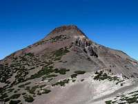
Carson-Iceberg Wilderness Area
The 160,000-acre Carson-Iceberg Wilderness Area was created in 1984 with the passage of the California Wilderness Act. This area lies within portions of Tuolumne and Alpine County and is bordered by Hwy 108 on the south and Hwy 4 on the north. The landscape is both rugged and beautiful and is dominated by volcanic ridges and peaks. There are fewer lakes than in the Emigrant and Hoover Wilderness areas to the south, but also fewer people.
Click here for a trail distance map.
Click here for a topo map.
 |
 |
 |
 |
There are many peaks still not documented on SummitPost, as you can see from the list below.
Peaks in the Carson-Iceberg Wilderness Area:
| Mountain | Elevation | Distance from Trailhead |
| Sonora Peak | 11,459' | 1.4 miles |
| White Mountain | 11,398' | 4.2 miles |
| Stanislaus Peak | 11,233' | 3.8 miles |
| Lost Cannon Peak | 11,060' | 8.5 miles |
| Whitecliff Peak | 10,893' | 6.5 miles |
| Wells Peak | 10,833' | 8.2 miles |
| Fish Valley Peak | 10,571' | 11.5 miles |
| Disaster Peak | 10,046' | 3.9 miles |
| Red Peak | 10,009' | 4.4 miles |
| Airola Peak | 9,942' | 4.7 miles |
| Iceberg Peak | 9,781' | 4 miles |
| Bald Peak | 9,715' | 2.7 miles |
| Dardanelles Cone | 9,524' | 3.8 miles |
| Boulder Peak | 9,393' | 7.4 miles |
| Lightening Mountain | 9,326' | 4.7 miles |
| The Iceberg | 8,350' | 0.8 miles |
Additional peaks listed in the Ebbetts Pass area.
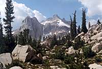
Emigrant Wilderness Area
What was formerly the Emigrant Basin was designated as the Emigrant Wilderness Area (EWA) on January 4, 1975. The 113,000-acre EWA is about 25 miles in length and up to 15 miles in width. It is bordered by Yosemite National Park on the south, the Hoover Wilderness Area on the east, and Hwy 108 and the Carson-Iceberg Wilderness Area on the north.
The EWA does not have the dramatic scenery of Yosemite Valley, however, it also does not have the crowds that Yosemite has during the summer. The glaciated landscape is consistent with that found in the backcountry of beautiful northern Yosemite. The northeastern third of the Wilderness is dominated by volcanic ridges and peaks; the remaining areas consist of many sparsely vegetated, granitic ridges interspersed with numerous lakes and meadows.
There are over 100 lakes and 22 named peaks within the EWA. Elevations range from below 5000 feet near Cherry Reservoir to 11,570 feet at Leavitt Peak.
Click here for a trail distance map.
Click here for a topo map.
 |
 |
 |
 |
Peaks in the Emigrant Wilderness Area:
| Mountain | Elevation | Distance from Trailhead |
| Leavitt Peak | 11,570' | 3.9 miles |
| Molo Mountain | 10,885' | 15.4 miles |
| Big Sam | 10,825' | 3.8 miles |
| Relief Peak | 10,808' | 8 miles |
| Kennedy Peak | 10,718' | 8 miles |
| Night Cap Peak | 10,641' | 1.7 miles |
| Bigelow Peak | 10,539' | 19 miles |
| Quartzite Peak | 10,414' | 18.5 miles |
| Grizzly Peak | 10,365' | 15.5 miles |
| Blackhawk Mountain | 10,348' | 10 miles |
| Granite Dome | 10,322' | 9.6 miles |
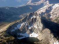
Hoover Wilderness Area
The Hoover Wilderness Area was given official wilderness area status in 1986 and expanded in 2008 to include the area along Highway 108. The Hoover Wilderness is bordered by the Emigrant Wilderness Area to the northwest and Yosemite National Park to the southwest. It encompasses 124,468 acres of lush green meadows, over 30 alpine lakes and some spectacular granite peaks. Elevations range from 7,640 to 12,446 feet. Some of the best Sierra climbing north of Yosemite can be found here.
Additionally, 12 miles of the Pacific Crest Trail pass through the Hoover Wilderness.
 |
 |
 |
 |
Peaks in the Hoover Wilderness Area:
| Mountain | Elevation | Distance from Trailhead |
| Tower Peak | 11,775' | 17 miles |
| Center Mountain | 11,273' | 8 miles |
| Forsyth Peak | 11,177' | 15 miles |
| Hawksbeak Peak | 11,143' | 10 miles |
Directions
From the West: Sonora to the Sonora Pass (70 miles):
Follow CA Hwy 108 east for 70 miles to the Sonora Pass or to your trailhead destination.
From the East: Bridgeport to the Sonora Pass (28 miles):
Follow I-395 south for 17 miles
Follow Hwy 108 west for 11 miles to the Sonora Pass or to your trailhead destination.
Guidebooks
Carson-Iceberg Wilderness, by Jeffrey P. Schaffer
Emigrant Wilderness and Northwestern Yosemite, by Ben Schifrin
External Links
Carson-Iceberg Wilderness Area Official USFS website.
Emigrant Wilderness Area Official USFS website.
Hoover Wilderness Area Official USFS website.
SonoraPassClimbing.com Rock climbing beta in the Sonora Pass area.
CalTrans District 10 updates on Twitter (local road closures)
Zscapes - Mountain Home (30 years of trip reports and photos from the Emigrant and Hoover Wilderness Areas)