
|
|
Area/Range |
|---|---|
|
|
39.44550°N / 106.1036°W |
|
|
Hiking, Mountaineering, Trad Climbing, Skiing |
|
|
Spring, Summer, Fall, Winter |
|
|
9000 ft / 2743 m |
|
|
Overview
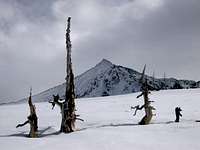 Pacific Peak
The Tenmile Range is a high mountain chain in the heart of Colorado. Located generally west of the ski town of Breckenridge, the Tenmile Range begins at the Tenmile Canyon, where it immediately rises from Interstate 70 at 9000 feet to the top of Tenmile Peak, which is nearly 13,000 feet. The range then rises steadily to over 14,200 feet before settling a bit before it ends at the Continental Divide. This high range boasts 5 Centennial Thirteeners and one very popular Fourteener, Quandary Peak. These high and relatively easy peaks make this range a popular destination, but solitude is very easy to find here on the several interesting and more obscure lower mountains of the range. Despite the easy nature of the peaks of this range, there are many routes here that offer technical challenges and scrambles. Additionally, big-mountain skiing is ideal here due to the large amount of snowfall the range gets in winter and spring - attested to by the fact that there are no less than 5 ski resorts within a 20 minute drive of the range. The skiing ranges from easy to extremely difficult. All in all, almost every sort of outdoor recreation is possible here - mountaineering, alpine rock climbing, alpine mixed climbing, big-mountain skiing, resort skiing, hiking, fishing, and camping, to name a few. The Tenmile Range is named for the ten numbered peaks of the range, which measure approximately ten miles (the entire range is greater in distance). The lower slopes of Peaks 7-10 comprise the popular ski resort of Breckenridge.
The Numbered Peaks of the Tenmile Range
| Peak 1 | 12,805 feet |
| Tenmile Peak | 12,933 feet |
| Peak 3 | 12,676 feet |
| Peak 4 | 12,866 feet |
| Peak 5 | 12,855 feet |
| Peak 6 | 12,573 feet |
| Peak 7 | 12,655 feet |
| Peak 8 | 12,987 feet |
| Peak 9 | 13,195 feet |
| Peak 10 | 13,633 feet |
To the south of the Tenmile Range lies the Mosquito Range. These ranges are often considered together, and therefore carry the confusion of two names. The Great Divide is the cause of the confusion - it snakes through the center of this greater range, causing the naming convention (see "Geology"). Thus, north of the Divide is the Tenmile, south of it is the Mosquito. North Star Mountain, and Hoosier Pass, lie exactly on the Divide, and this area is the line of demarcation. Most people stop by the Tenmile Range just to bag its big Fourteener, Quandary Peak, or maybe to bag a few of the big Thirteeners that reside here. Commonly, people refer to the range as "crowded" and "easy," but these folks haven't looked deeper into this range. A trip onto one of the lesser peaks of this range will likely change your mind about it. Climb a fun route on Father Dyer Peak, ski Peak 10's Fourth of July bowl, or scramble along the numbered peaks. Avoid the crowds on Quandary on it's West Ridge or Cristo Couloir. You'll quickly gain an appreciation for the Tenmile Range.
 A reminder of the mining days near Wheeler Mountain
Area History
 Mount Helen and Mohawk Lakes
Gold Rush
The Tenmile Range area was an ancestral hunting area for the nomadic Ute people long before White settlers crossed the Mississippi. White miners flocked to this region after gold was discovered in the Blue River in the 1850s, during the Pikes Peak gold rush. General George Spencer founded the area and named the town he created "Breckinridge," after James Buchanan's Vice President. With the outbreak of the Civil War, Vice President Breckinridge's sympahthies clearly laid with the South, so the embarassed residents of "Breckinridge" re-named their town by its current name, Breckenridge. General Spencer laid out a grid for the town of Breckenridge, with Main Street going in adjacent to the Blue River. By 1861, Breckenridge was a full-fledged Western mining town, replete with saloons, hotels, miners' shacks, and a post office. The mining expolitation of the surrounding mountains had begun in earnest. By the late 1860s, the initial gold rush had died, and Breckenridge began to falter as a town. Introduction of large-scale placer mining brought life back to the town. By 1882, Breckenridge secured a depot site for the Denver, South Park and Pacific Railroad and thereby brought rail service to Town. Breckenridge doomed a half dozen other rival company towns in the process. The population of Breckenridge peaked at approximately 2000. By 1882, Breckenridge added three newspapers and a cemetery. Breckenridge was home to one of the most famous evangelists in Colorado history - Reverend John Lewis Dyer. The Methodist minister, known as the “Snowshoe Itinerant,” walked and skied his way through the mountains, taking the gospel to those who might not otherwise hear it. Carrying heavy canvas sacks of mail over the snow-packed mountain passes, including 13,000 foot Mosquito Pass, Father Dyer gained a reputation as a miners' preacher. In 1880, he built Breckenridge's first church, mostly by hand, now located on Wellington Road. Father Dyer is immortalized in the Colorado Capitol in a stained-glass representation. Two mountains in the area, Father Dyer Peak and Dyer Mountain are named for this pioneer.
"No Man's Land"
By the turn of the Twentieth Century, Breckenridge had less than 1000 inhabitants. The town was never a ghost town, but most of the original gold-rush era buildings were lost to fire, theft, and neglect. Indeed, residents in the 1930s realized that Breckenridge was not even included on US maps. Some residents called the town, "No Man's Land." The Great Depression nearly killed the town completely. By the 1940s, less than 300 residents lived in the town.
 The Tenmile
"White Gold"
In December 1961, Rounds and Porter, a Wichita, Kansas, lumber company, opened the Breckenridge Ski Area and a new-boom era began. Transportation improvements like The Eisenhower Tunnel, on Interstate 70, gave rise to the Summit County recreation industry. Where miners once came here for gold, skiers now flocked to the Tenmile Range for "white gold" - snow. The population in 1960 was a mere 300 souls; by 2002 the town had over 3,000 full-time residents. Millions of visitors now come here each year for all-season recreation in these beautiful mountains.
The Impact of History on the Tenmile Range
While miners flocked to this area to make their fortunes, the Tenmile Range suffered greatly. Early mining methods had a permanent impact on these ancient mountains. Visitors to the Tenmile Range often comment on the ubiquitous mining structures left nearly everywhere in these mountains. The Blue River had been completely dredged in the 1860s. The Denver South Park railroad pounded its way across the mountains, leaving track and structures. Although it is very interesting to travel through these mountains and see their history first-hand, the impact that mining had here was extremely damaging to these mountains. More so than other Colorado ranges, the ravages of history are clear in the Tenmile.
Geology
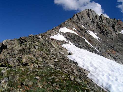 Father Dyer Peak
Tenmile Canyon
The Tenmile Canyon forms the northern end of the Tenmile Range. This canyon is a northeast facing fault-controlled gash nearly 3,000 feet deep through the shared Precambrian core of the north-trending Laramide Gore-Tenmile uplift. Travelers through Colorado know this area better as the I-70 corridor that runs through the Gore Range to the north and the Tenmile Range to the south, also housing Copper Ski Area. Tenmile Canyon's high walls are easily observed from any vehicle traveling here.
Tenmile Creek
Now nothing more than a trickle from the headwaters of Climax and Fremont Passes, Tenmile Creek runs through Tenmile Canyon. It is likely that this creek was much more during the Pliocene climate and the during the subsequent Pleistocene glaciations, but it was not likely to have been a major river at any time in its history. If anything, it merely aided in the formation of Tenmile Canyon.
The Tenmile Range
Tenmile Range stands high on the east shoulder of the Rio Grande Rift (RGR). No less significantly, it also stands directly astride the Colorado Mineral Belt (CMB). Although the processes that formed the Gore Range also formed the Tenmile, the two ranges grew apart when later geologic events changed the Tenmile. The Precambrian core of the Tenmile Range is continuous across Tenmile Canyon with the core of the southern Gore Range, but Tenmile isn't part of the Gores. It no doubt rose in Laramide time, but it probably rose more, via normal faulting and mantle-related uplift, with the east shoulder of the Rio Grande Rift in late Tertiary time, after the main pulse of Laramide deformation had ended. On the east flank of the Tenmile Range, Cambrian through Cretaceous sedimentary strata rest unconformably on the Tenmile Precambrian core. Their structural relationships to the core and to one another remain uncertain, but these densely intruded sediments played a pivotal role in the mining history of the Tenmile Range. In Pliocene and Pleistocene time, the Tenmile Range saw much less glaciation than the Gore Range and now has a much less craggy look to show for it. Whether it stood lower than the Gore then, or stood off the prevailing easterly storm tracks of the time, or received more shielding from higher peaks to the east, is unclear, but to this day, the resulting topographic difference is striking, especially from the air. Otherwise, the higher reaches of the Tenmile and Gore Ranges are physically similar, having been exhumed from similar Precambrian rock. For better or for worse, The Tenmile's location at the intersection of the Colorado Mineral Belt and the Rio Grande Rift and its smoother topography destined the Tenmile Range to attract much more mining, residential, resort, and recreational development than the Gore Range, much of which remains designated wilderness to this day. The Mosquito Range to the south seems to be a continuous range with the Tenmile, however there are several geologic reasons to separate them, even if convention had not named the two ranges differently. Obviously, and most importantly, the Continental Divide snakes through here from the Front Range going westerly across a ridge, known as North Star Mountain. Secondly, the Colorado Mineral Belt (CMB) follows this anomaly between the two ranges. Geologists cannot yet explain why. This ridge, not only the Great Divide, also forms a wall of South Park.
Access
Access to the Tenmile Range is very good, even during winter and spring. As a heavily-mined region, there are many mining roads that offer great, high altitude access to almost all the major peaks of this range. Most of the trailheads are on the east side of the range, but there is one on the west on Colorado 91.
 Quandary Peak
Safety Contact Numbers, Lodging, and Camping
 Skiing Peak 10
Safety Contact Numbers
The Tenmile Range is within Summit County, Colorado. Use the following phone numbers in an emergency. County Office: (970)453-2561 Sheriff: (970)453-2232 Summit County also has a Search and Rescue Unit: Summit County SAR
Lodging
Because of the ski industry, there are many hotels, motels, hostels, and resorts adjacent to the Tenmile. Use your favorite lodging search and check the towns of Breckenridge, Dillon, and Frisco. Using the lodging function from Snow.com will allow you to search multiple towns at once and compare rates.
Camping
Unfortunately, there are no formal campsites in this area. Wilderness camping abounds. As always, ensure that you Leave No Trace.
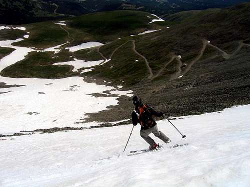
Skiing the Tenmile
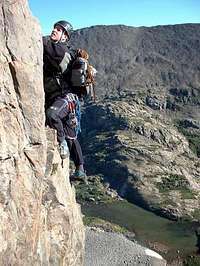 Quandary's Inwood Arete
Resort Skiing
Breckenridge Mountain Resort comprises the lower slopes of Peaks 7,8,9 and 10 in the Tenmile. With the addition of the Imperial Lift in 2005, Breckenridge now boasts the highest lift in North America, rising to nearly 13,000 feet. Consistently ranked in the Top 20 resorts in the world, Breck has over 2200 skiable acres with a wide variety of terrain from extremely easy bunny slopes to one of the steepest in-bounds runs in North America, Lake Chutes, which top out near 50 degrees. Breckenridge Mountain Cams Current Grooming Report (Adobe) Current Snow Report Trail Map
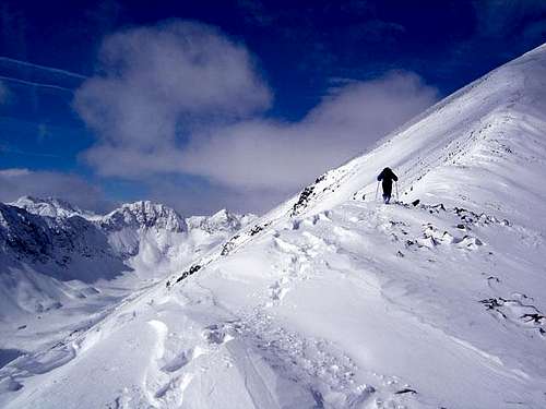
Backcountry Skiing
Backcountry Skiing abounds in the Tenmile Range. Many of the big mountains of the Tenmile offer several different options in all skill levels. On Summitpost, you will find several routes in this range dedicated to ski descents. On a good year, you may be able to ski well into July. Because of the large amount of snowfall in this range yearly, avalanche danger is typically considerable. Always practice sound avalanche avoidance techniques, and be sure to use the link below. Colorado Avalanche Information Center Link for Tenmile Region
Tenmile Range "Must-Do" Mountains and Routes
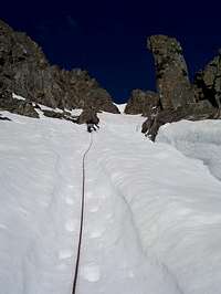 Pacific Peak's North Couloir
Quandary Peak - East Ridge (Hike) This is a classic, easy route to a high Fourteener. Expect plenty of company. Quandary Peak - West Ridge (Scramble) This classic route takes you on a gorgeous hike through hanging valleys to a perplexing scramble to Quandary's summit. Quandary Peak - Inwood Arete (Alpine Rock Climb) The premier rock route in the Tenmile. Several pitches of Class 5+ climbing on an aesthetic arete. Quandary Peak - Cristo Couloir (Snow Climb / Ski) This dangerous, steep, avalanche-prone route has seen many fatalities and injuries over the years. That said, it is an extremely fun ski descent in late Spring on safe snow. Pacific Peak - Northeast Slopes via Spruce Creek (Moderate Snow) This route begins with a hike past several waterfalls and lakes, continues with a moderate snow climb, and ends with an exciting run up the summit pyramid of Pacific.
 Climbing the East Ridge of Quandary Peak
Pacific Peak - North Couloir (Alpine) This is the premier Alpine Climb of the Tenmile Range. This aesthetic route climbs snow, ice, and rock to an angle of 70 degrees to the summit of Pacific. Peak 10 - Northeast Face Ski Descent (Ski) Also called the 4th of July Bowl (because you can probably still ski it on Independence Day each year), this classic line holds great snow and offers a few selections of difficulty, all Expert. Wheeler Mountain - South Ridge (Scramble) Wheeler Mountain stays hidden from view deep in the Tenmile, and its rocky summit sees very few visitors. Try this fun scramble. You'll definitely have solitude here. Father Dyer Peak and Mount Helen - Ridge Traverse (Scramble) This is a very enjoyable ridge traverse between two seldom visited 13ers. There are a few exposed and fun scrambles along the ridge. Father Dyer Peak - Dyer Straits (Snow Climb / Scramble) Hit this one late in Spring for a fun snow climb to a ridge scramble. Tenmile Peak (Peak 1) - North Ridge (Hike) The classic route to the beginning of the Tenmile Range. Great views.
 Peak 10's Northeast Face
 Peak 10's Northeast Face