

-
 109428 Hits
-
 98.93% Score
-
 93 Votes
|
|
Area/Range |
|---|---|
|
|
43.74110°N / 110.802°W |
|
|
Hiking, Mountaineering, Trad Climbing, Sport Climbing |
|
|
Spring, Summer, Fall, Winter |
|
|
13770 ft / 4197 m |
|
|
Overview
The Teton Range! Just the name generates visions of towering peaks, roaring creeks, waterfalls, challenging hikes and climbs. Blue and emerald lakes abound. Few mountain ranges in the United States rival the Tetons for raw beauty. Words such as awesome, stunning, dazzling, spectacular and magnificent have been used to describe this area of western Wyoming but when one views this jagged line of peaks, words fail to fully describe what nature has wrought. The range extends over 40 miles from the southern border of Yellowstone National Park with foothills extending into southeast Idaho.
Here is a great link for up-to-date route conditions on several mountains in the Teton range: www.TetonClimbing.blogspot.com.
Featured Trip Report: Lake Of The Crags At Last by Rob Thompson
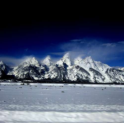
January 2008 from near the Snake River on way to Yellowstone. Photo by 612boudou
Demanding climbs to enchanting hikes. Wildlife such as Wolves and Grizzly Bears. Meadows full of colorful wild flowers. A World Class ski area. And much, much more!
Seeing these peaks stirs the soul and fuels the desire to explore high places. It doesn't get much better than this!
There is something for everyone here, and once you visit this very special place, you dream of returning again and again.....
BTW: A common mistake is for people to call the Teton Range "The Grand Tetons." The proper term is "the Tetons" or "the Teton range." The Grand Teton is a single mountain and deserving of distinction.
Geology
You can read the past as you view the present Teton Range. The ancient geologic processes that created the mountains and valley have left evident marks. You can see millions of years of dynamic geology open up before you while exploring the Tetons.
Two rectangular blocks of the Earth's crust moved like giant trap doors, one swinging skyward to form the mountains, the other hinging downward to create the valley. Wind, rain, ice, and glaciers constantly eroded the rising range. Meanwhile, enormous glaciers and torrential melt waters flowed southward carrying cobbles, gravel, and coarse sand and periodically re-leveled the floor of the sinking valley.
Vertical movement along the Teton fault approaches an amazing 30,000 feet. Evidence for the amount of movement comes from the present location, on the summit of Mt. Moran (6,000 feet above the valley floor) a pink cap of Flathead Sandstone. On the valley side of the fault, this formation lies buried at least 24,000 feet below the surface.
 The Diabase dike, which juts vertically out of the CMC face of Mount Moran. Photo by Jackson Herring
Of special interest - Diabase, a dark-colored igneous rock, 1.3 billion years ago flowed up through the gneiss and granite, resulting in the prominent vertical dikes seen today on the faces of Mt. Moran and the Middle Teton. The diabase dike on Mt. Moran protrudes from the face because the gneiss surrounding it erodes faster than the diabase. The diabase dike on the Middle Teton is recessed because the granite of the central peaks erodes more slowly than the diabase.
Twelve small glaciers still cling to the Tetons. They are the offspring of the original glaciers and were formed in the most recent mini-ice age, between 500 and 1,000 years ago.
 Brendon's shot from top of Fossil Mountain
History
Native PeoplesArchaeological evidence reveals that bands of Paleo-Indians made summer camps near the Tetons soon after the last major ice age ended about 9000 B.C. It appears they used the valley to gather plants for their edible roots. The valley's big-game populations weren't large enough to support more than occasional hunting.
Historians ponder why these early bands of people left the area between A.D. 1000 and 1600 to be replaced by today's more commonly known tribes of Shoshone, Crow, Gros Ventre, and Blackfeet. Even these "modern" tribes were infrequent visitors to the Tetons; they basically followed the ancient animal trails as they crossed the Continental Divide.
Explorers Arrive
After Lewis and Clark's expedition passed to the North and headed back East in late 1806, member John Colter, at the mouth of the Platte River, met up with Manuel Lisa's expedition, which intended to establish a fur trade on the Upper Missouri. Lisa persuaded him to help them with their endeavor. Lisa's party established Fort Raymond near the Bighorn and Yellowstone Rivers and in the fall of 1807, Colter invited neighboring tribes to the fort to trade beaver furs. It was during this time of exchanges with the Indians that Colter first visited Jackson Hole.
When beaver hats fell from fashion in the 1840s, so did the Tetons. Almost 50 years passed before another wave of newcomers found the valley promising enough to settle.
Survey Expeditions
In 1840, mountain man Jim Bridger led Army Capt. William Raynolds' survey party through the valley. They collected information about the native tribes, farming and mining possibilities, and railroad routes.
In conjunction with his exploration of the Yellowstone region, young geologist Ferdinand Hayden made several forays into the Tetons. Jenny, Leigh, Bradley, and Taggart lakes owe their names to members of his 1872 survey expedition. Jenny was the Shoshone wife of mountain man and guide "Beaver" Dick Leigh, Frank Bradley was chief geologist on the team, and W. R. Taggart was his assistant. Another member who helped make the Tetons famous was William H. Jackson. That same year, President Ulysses Grant declared Yellowstone the world's first national park. This act was the start of a new industry in the region - tourism - and the Tetons were soon attracting their own share of admiring visitors.
Homesteaders Take Root
The Homestead Act of 1862 granted 160 acres of land to anyone who promised to live and build on it for five years. It seems that the offer of free land influenced many ranchers and farmers to overlook this region’s meager grazing and farming conditions. New settlers, found just surviving to be a struggle.
William Menor opened a ferry in 1894 to cross the Snake River at Moose.
Hunting guide Ben Sheffield started bringing wealthy clients to his camp at Moran. Homesteader Louis Joy opened the first dude ranch in the valley. Attracting visitors from around the world to the Tetons proved much more profitable than agriculture.
TETON CLIMBING HISTORY: THE SUMMIT REGISTER ARCHIVE: This site contains a collection of digital images of the Grand Teton National Park Summit Register Archive. The summit registers were maintained from about the late-1920s into the 1980s and they form a unique repository of Teton climbing history.

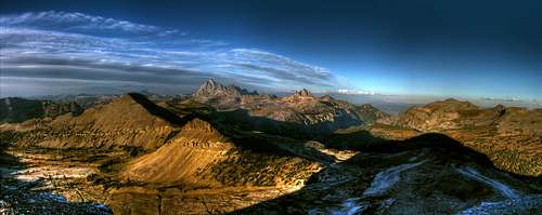
Tetons Pano taken by Biglost
The Making Of A Park
The Tetons first received government protection in 1897 when Congress created the Teton Forest Reserve out of land not included in Yellowstone National Park. In 1929, a strip of land that included the Teton mountain range and little else officially became Grand Teton National Park. It was just a third the size of the present park. As early as 1917, congressmen were trying to create a larger sanctuary. Local residents fought, and crushed, three attempts to federalize their land in Jackson Hole.Then John D. Rockefeller, Jr., entered the fray. In 1926, he toured Jackson Hole with Yellowstone Park Superintendent Horace Albright, who believed the Teton Mountains' magnificence would be spoiled if the valley below them was left to uncontrolled development. Rockefeller, one of the wealthiest men in the world at that time, agreed.
Congress appeared deadlocked on the issue of expanding Grand Teton National Park, Rockefeller took matters into his own hands. He quietly bought 35,000 acres of farm and ranch land between 1927 and 1943. Rockefeller's stated goal was to donate the property for an expanded park. But congressional and local resistance kept the government from accepting the gift for 15 years. So Rockefeller forced the issue in 1943 by threatening to sell his holdings on the open market.
President Franklin Roosevelt responded by declaring 221,000 acres east of the Snake River - most of the remaining valley - Jackson Hole National Monument. His move took advantage of the fact that creating a monument didn't call for congressional endorsement the way a national park would. Even though 93% of those acres already belonged either to the government or Rockefeller, Wyoming residents still felt betrayed. Congress first passed a bill abolishing the monument, which Roosevelt vetoed. A compromise was reached and in 1950, it was decided that in exchange for land, the federal government would reimburse Teton County for tax losses and honor grazing rights for the lifetime of existing leaseholders and their heirs living at the time. Finally, Jackson Hole National Monument became part of Grand Teton National Park.
Today, most people would agree that Grand Teton National Park is a valuable asset of Jackson Hole and the nation. Since the founding of the park, tourism has surpassed ranching to become the economic foundation of the region.
[img:201851:aligncenter:medium:The End of Another Beautiful Day...]
The Peaks-- A Climbing Overview
Newcomers to the range might wonder where to begin, and the range has mountains for all levels. This section provides an overview of the peaks that have SP pages and organizes them by the type of standard route-- technical rock climb, scramble, or hike. With each peak description is the rating of the standard route on it.Do note that many of the peaks have several routes on them.
Technical Peaks
Class 5
Grand Teton-- 5.4 by standard route (Owen-Spalding); this mountain needs no introduction.
Mount Owen-- This spire is the second-highest peak in the range and seems almost within leaping distance of the Grand (leaping not recommended). From some locations, especially in lower Cascade Canyon, it may at first actually be mistaken for the Grand. The easiest route-- West Ledges-- goes at 5.1.
Mount Moran-- It is the fourth-highest peak in the range, but only the Grand gets more attention. Its position several miles away from the Cathedral Group-- the Grand, Owen, and Teewinot-- makes it stand out almost as much as the Grand does. The standard route is the 5.5 CMC. Many climbers prefer Moran to the Grand because the longer approach means more of a wilderness feel and a reprieve from the crowds that flock to the Grand.
Thor Peak-- A seldom-seen peak for vehicle tourists and even many hikers and some climbers, this mountain "hides" behind Mount Moran. It is 5.6 by the "Hidden Couloir"; see the TR attached to the peak page for details, as the peak page does not contain route information.
Nez Perce Peak-- One of the cluster of peaks near the Grand, this peak's Northwest Ledge Route goes at 5.4.
Matternought Peak-- One of the lesser-known gems. The easiest route is via the east ridge and east couloir and goes at 5.1.
Cube Point-- Not high as Teton peaks go, but more secluded than the big ones are even though it is not very far from the Grand. It is a good choice for a day climb, and the East Ridge is 5.4.
Baxter's Pinnacle-- Virtually unknown except to technical climbers, this peak only takes a few hours to climb. The South Ridge/Face has crux moves of 5.9, but most of the climb is easier than that (5.6 range).
Thumbs of the Peaks
 Grand Teton Grand Teton |
 Mount Moran Mount Moran |
 Mount Owen Mount Owen |
 Thor Peak Thor Peak |
 Nez Perce Peak Nez Perce Peak |
 Matternought Peak Matternought Peak |
 Cube Point Cube Point |
 Baxter's Pinnacle Baxter's Pinnacle |
Scrambles
Harder Class 2 through Class 4
Middle Teton-- Third among the peaks in height, this is the highest Teton Peak with a summit accessible by a non-technical route. That route is the Southwest Couloir, Class 3 (though it should be noted that the SP page mentions a few Class 4 spots).
South Teton-- The third and lowest of the "Teton" peaks, this one has two Class 4 routes (though the going is mostly Class 3). The South Teton is often used as an introductory peak for people getting a taste of Teton mountaineering.
Teewinot Mountain-- Class 4 (East Face) and more exposed than most other Class 4 routes in the range. Many parties rope up on this peak, especially on the descent, and it verges on being technical. It should also be noted that some published descriptions put the route at 5.3 since it is easy to end up on Class 5 terrain in some of the Class 4 sections.
Cloudveil Dome-- Class 4 by the east ridge. This peak is the eastern end of the east ridge of the South Teton.
Buck Mountain-- This is the highest peak in the southern part of the range, and it stands out commandingly from almost every vantage of it. There are technical routes on the peak, but there are also some Class 3 and 4 routes. The easiest seems to be the East Face (Class 3), documented on a route page by one of SP's better contributors.
Disappointment Peak-- The first people to climb this peak had hoped they could traverse from it to the Grand relatively easily. Instead, they encountered a deep drop that they were unable to negotiate, even on rappel, and they gave this peak its name. The southeast ridge offers a Class 3/4 route.
Mount Wister-- This is a peak most people never see. It is in the heart of the park but just far enough away from the trophy peaks to attract little attention. The east ridge is a Class 3 scramble.
Mount St. John-- Usually appreciated only from the road, this peak is the highest point of the ridge system separating Cascade and Paintbrush Canyons, and some of the park's most popular trails encircle the ridge, but not a lot of people climb the peaks there. A Class 3 scramble ascends the south couloir to the summit.
Mount Fryxell-- Another peak along the ridge complex between Cascade and Paintbrush Canyons, this one has outstanding views of the park's greatest mountains and grabs much visual attention at Paintbrush Divide and during the final push up to the divide from Paintbrush Canyon. A route up this peak can be anywhere from a loose Class 2 to a mix of Class 2-4, and there is a large snowfield that offers an interesting climb, fast descent, or both.
Rockchuck Peak-- Yet another peak on the ridge system between Cascade and Paintbrush Canyons. Its easiest route is a Class 3 one from the east.
Symmetry Spire-- This aesthetic peak between Cascade and Hanging Canyons mostly appeals to rock climbers, but its east ridge and southwest couloir offer Class 4 routes.
Storm Point-- Very close to Symmetry Spire, this pinnacle has a Class 4 route and a short approach.
Ice Point-- Another spire in the group containing Symmetry Spire and Storm Point, this one also has a Class 4 route.
Class 1 and 2
Static Peak-- Probably no other peak in the range offers so much in scenery for so little (relatively-- for it is a long, steep hike) effort. The mountain itself is not so scenic-- it appears as an unassuming bump dwarfed by its close neighbor Buck Mountain-- but there is a good trail for 8 of the 8.5 miles of the way to the top, and the rest, which is not even half a mile, is an easy walk up a use trail.
Table Mountain-- Table Mountain may be the only major peak in the park with a maintained trail all the way to its summit, and that trail is accessed from the western side of the range, which is not unknown but still receives far less attention than the eastern side does.
Taylor Mountain-- Taylor is near the southern end of the range, just north of Teton Pass. Class 1 and 2 hiking gets you to the top.
Mount Glory-- Glory is also at the southern end of the range, and it is a short trail hike to its top. Mount Glory is popular with skiers as well.
Grand Teton National Park
PO Drawer 170
Moose, WY 83012-0170
(307) 739-3300
Bridger-Teton National Forest
P.O. Box 1888
Jackson, WY 83001
(307) 739-5500
Caribou-Targhee National Forest
1405 Hollipark Drive
Idaho Falls, Idaho 83401
(208) 524-7500
ENTRANCE FEES FOR GRAND TETON NATIONAL PARK
Vehicle single entry $20.00 for 7 Days, $10.00 per person for single hiker or bicyclist, or $15.00 per motorcycle. You may also purchase an "America The Beautiful Federal Lands Recreational Pass" for $80.00 which is good for entrance to all National Parks, National Forests, BLM, US Fish & Wildlife, and Bureau of Reclamation sites for one year from date of purchase. If you're disabled, you may want to get an Access Pass which are free and good for a lifetime. If you're 62 years of age or older, a Senior Pass can be purchased for $10 and they're also good for a lifetime. Click here for more info on fees and passes. Existing National Park Passes and Golden Age/Access/and Eagle Passes will be honored until they expire. (Info courtesy of SP Member Sequoia)
BACKCOUNTRY REGULATIONS
Symmetry Spire-- This aesthetic peak between Cascade and Hanging Canyons mostly appeals to rock climbers, but its east ridge and southwest couloir offer Class 4 routes.
Storm Point-- Very close to Symmetry Spire, this pinnacle has a Class 4 route and a short approach.
Ice Point-- Another spire in the group containing Symmetry Spire and Storm Point, this one also has a Class 4 route.
Thumbs of the Peaks-- 1


Thumbs of the Peaks-- 2
 Mount Wister Mount Wister |
 Mount St. John Mount St. John |
 Mount Fryxell Mount Fryxell |
 Symmetry Spire Symmetry Spire |
 Storm Point Storm Point |
 Ice Point Ice Point |
Hikes
Class 1 and 2
Static Peak-- Probably no other peak in the range offers so much in scenery for so little (relatively-- for it is a long, steep hike) effort. The mountain itself is not so scenic-- it appears as an unassuming bump dwarfed by its close neighbor Buck Mountain-- but there is a good trail for 8 of the 8.5 miles of the way to the top, and the rest, which is not even half a mile, is an easy walk up a use trail.
Table Mountain-- Table Mountain may be the only major peak in the park with a maintained trail all the way to its summit, and that trail is accessed from the western side of the range, which is not unknown but still receives far less attention than the eastern side does.
Taylor Mountain-- Taylor is near the southern end of the range, just north of Teton Pass. Class 1 and 2 hiking gets you to the top.
Mount Glory-- Glory is also at the southern end of the range, and it is a short trail hike to its top. Mount Glory is popular with skiers as well.
Thumbs of the Peaks


Red Tape
Many parts of the Teton Range are on private property and access should only be with permission from the land owners. Otherwise, the majority of the range falls within several federal agencies including: the National Park Service, the U.S. Forest Service, and the U.S. Fish and Wildlife Service. These areas include: Grand Teton National Park, Bridger-Teton National Forest, Caribou-Targhee National Forest, National Elk Refuge, Jedediah Smith Wilderness, and the Teton Wilderness. Depending on your destinatin, all of these jurisdictions have their own rules and regulations regarding hiking, climbing, camping, and other activities. It is the responsibility of the individual to know these rules and abide by them to preserve these areas for everyone.Grand Teton National Park
PO Drawer 170
Moose, WY 83012-0170
(307) 739-3300
Bridger-Teton National Forest
P.O. Box 1888
Jackson, WY 83001
(307) 739-5500
Caribou-Targhee National Forest
1405 Hollipark Drive
Idaho Falls, Idaho 83401
(208) 524-7500
ENTRANCE FEES FOR GRAND TETON NATIONAL PARK
Vehicle single entry $20.00 for 7 Days, $10.00 per person for single hiker or bicyclist, or $15.00 per motorcycle. You may also purchase an "America The Beautiful Federal Lands Recreational Pass" for $80.00 which is good for entrance to all National Parks, National Forests, BLM, US Fish & Wildlife, and Bureau of Reclamation sites for one year from date of purchase. If you're disabled, you may want to get an Access Pass which are free and good for a lifetime. If you're 62 years of age or older, a Senior Pass can be purchased for $10 and they're also good for a lifetime. Click here for more info on fees and passes. Existing National Park Passes and Golden Age/Access/and Eagle Passes will be honored until they expire. (Info courtesy of SP Member Sequoia)
BACKCOUNTRY REGULATIONS
- Respect wildlife: Do not approach or feed animals. Observe and photograph from a safe distance; stay at least 300 feet away from large animals.
- All overnight camping requires a permit.
- Carry out all your garbage.
- Hike on established trails to prevent erosion.
- Pets, weapons, bicycles or vehicles are not allowed on trails or in the backcountry.
- Backcountry sanitation: To prevent contamination of waterways, bury feces in a hole 6-8 inches deep at least 200 feet from streams and lakes. Pack out used toilet paper, tampons, sanitary napkins and diapers in sealed plastic bags. Do not bury or burn them.
Camping / Lodging
Grand Teton National Park
Everything you wanted to know about Grand Teton National Park
GTNP
Colter Bay Campground
Open From Mid May To Mid September.
25 miles north of Moose, with 350 sites, also has showers, a laundry and a trailer dump station. Fills about noon. Colter Bay is a wooded campground with larger sites and easier access if you are traveling with a camper, trailer or RV. Close to Jackson Lake with plenty to do close by.
Flagg Ranch Campground
Concession operated, located just south of Yellowstone National Park's south boundary. 175 sites in the spruce-fir forest. Call for reservations for both trailer sites and tent sites. For More Information call (800) 443-2311
Gros Ventre Campground
Open From Late April To Mid October.
11.5 miles south and east of Moose, with 360 sites and a trailer dump station. Generally fills in the evening, if at all. The campground lies along the Gros Ventre River with a mix of sites in sagebrush, beneath cottonwoods and adjacent to but a short distance from the river. If you are arriving in the afternoon of a busy day, just pull in. Seek a better site the next morning.
Jenny Lake Campground
Open From Mid May To Mid September.
8 miles north of Moose, 49 sites, tents only. This is the park's most popular campground and is generally full by 8 a.m. Sites are in among the evergreens and glacial boulders a short distance from Jenny Lake.
Lizard Creek Campground
Open From Mid June To the Beginning of September.
At the north end of Grand Teton National Park, about 32 miles north of Moose, has 60 sites and fills by about 2:00 p.m. A less heavily developed campground with sites in the spruce and fir forest. One side of the campgound is adjacent to and slightly above Jackson Lake. Vehicle size limited to 30 feet.
Signal Mountain Campground
Open From Mid May To the Beggining of October.
16 miles north of Jenny Lake, 86 sites and a trailer dump station. Fills by about 10 a.m. Signal Mountain offers a mix of spruce and fir trees, hillsides, and lake and mountain views. Adjacent to Signal Mountain Lodge and marina with a campstore and amenities close by. Sites are generally small and intimate. Vehicles size limited to 30 feet.
American Alpine Club Climbers Ranch
The best option to camping before your climb is to stay at the American Alpine Club's Climber’s Ranch located 7 miles past Moose Junction on Teton Park Road. The Ranch offers very rustic accommodations for only $20/per night. Very rustic means you bring your own bedding, mattress, etc., and you will be sharing a cabin with other climbers. Showers and a cooking area are available. Lodging is on a first come, first served basis but reservations are accepted. You can make an online reservation here or call (307) 733-7271 between June 1 and September 30. You do not have to be a member of the American Alpine Club to stay there; however, the AAC rate is only $10.00/night.
AAC Grand Teton Climbers Ranch:
ATTN: Manager
P.O. Box 57
Moose, WY 83012
Email: gtcr@americanalpineclub.org
Backcountry Camping Permits: Permits are needed for backcountry camping if using a high camp. Free permits are available at the Jenny Lake Ranger Station on a first come, first served basis. A limited number of permits can be made in advance by submitting your request in writing to the address or FAX number below. Reservations may be made as early as January 1 and are accepted up to May 15. Although the permit is free, there is a $15.00 non-refundable reservation fee. For more information call (307) 739-3397 or (307) 739-3309. Even though you have a reserved permit, you must pick up your permit in person by 10:00 am the morning of your trip or they will make it available to others. Backcountry Camping Brochure (PDF)
Grand Teton National Park
Permits Office
P.O. Drawer 170
Moose, WY 83012
(307) 739-3438Other Recreational Activities
Teton Pines Resort and Country Club
A year-round resort facility featuring golf, tennis, fly fishing, cross-country skiing, dining, and Jackson Hole's finest lodging; near Grand Teton and Yellowstone National Parks.
Teton Pines
Ski Jackson Hole
One of the best Ski Resorts in North America. 2006 was the last season for the Tram. Plans for replacement are still undecided....
Update...A new Tram is currently being constucted. It will provide twice the capacity of the old one.
Jackson Hole Mountain Resort
Snow King
Right in Jackson....very reasonable.
Snow King
Guest/Dude Ranches
Many places to stay and participate in activities such as Horse Back Riding, a float trip on the Snake River or Western Style Cookouts!
Guest Ranches
National Elk Refuge
Visit the refuge in the winter and take a sleigh ride to where the elk are being fed.
National Elk Refuge
References
US Department of Agriculture - National Park Service
(Geology / Parks and Recreation / History and Culture)
Most of the work on this page courtesy of Biglost