Corno Bussola is the main summit in the "Lake District" of Palasina, an highland where nature captured waters in several wonderful wells. There are lakes "for all tastes", different colors, different light exposition. To visit and hike in Palasina Lake District (... Lake District is a nickname ... don't refer to this place with this name! ...) is good for practise mountain wilderness photography. Climbing the Northern border (E to W from Punta Palasina to Corno Bussola), a long and large grassed ridge (except ending solution to Corno Bussola), allows the hiker to admire great sight on Matterhorn and Monte Rosa group.Since 1995 the Arp Hut, or better Arp Hotel (over 100 beds!), is open in summer season for hikers. An easy access from Brusson, via Estoul Hamlet, allow to get there a lot of people in summer season. For these reasons, in August and during summer week-end, the Lake District is a little bit crowded. Better visit it in late or early season.
Il Corno Bussola è la cima principale del "Comprensorio dei Laghi" di Palasina,un altopiano dove la natura ha catturato le acque in diversi meravigliosi Laghi. Ce ne sono "per tutti i gusti", diversi colori, diverse esposizioni luminose. Per visitare e fare escursioni a Lake District Palasina (... Lake District è un soprannome ... non si riferiscono a questo posto con questo nome! ...) è buono per la pratica fotografica della montagna selvaggia. Salendo al confine Settentrionale (da Est ad Ovest ovvero dalla Punta di Palasina al Corno Bussola), una lunga e larga dorsale erbosa (esclusa la parte terminale del Corno Bussola), consente all'escursionista di ammirare grandi vedute sul gruppo del Cervino e del Monte Rosa. Dal 1995 il Rifugio de l'Arp, o meglio l'Arp Hotel (oltre 100 posti letto!), risulta aperto nella stagione estiva per gli escursionisti. Un facile accesso da Brusson, attraverso il Villaggio di Estoul. Per questo motivo, in agosto e durante il fine settimana estivo, il Lake District è un poco sovraaffollato. Meglio visitarlo in ritardo o all'inizio della stagione.
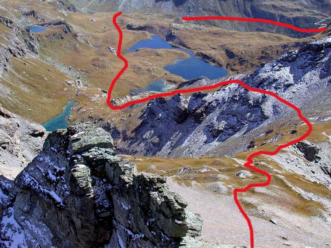
Syntetically, refer to route description for further details. Upper right: Case Palasina, where starts the long traverse under Monte Bieteron. Center shot: Laghi della Battaglia and, half-hidden, Lago Pocia. Center left: Lago Lungo. Center right: delicate traverse to Colle Bussola. Right corner: Colle Bussola.
In sintesi, facendo riferimento alla descrizione del percorso per ulteriori dettagli. In alto sulla destra: Case Palasina, dove inizia la lunga traversata sotto Monte Bieteron. Centralmente: Laghi della Battaglia e, seminascosto, Lago Pocia. Verso il centro ed a sinistra: Lago Lungo. Al centro e sulla destra: traversata delicata fino a Colle Bussola. All'angolo destro: Colle Bussola.
First Ascents
First on the summit: Unknown.
In winter: Unknown.
Great Traverse: (Corno Vitello-Punte Palasina or Palasinaz-Punta del Lago-Corno Bussola-Quota 2.899 metri): Osvaldo Cardellina, Roberto Stella (until Corno Bussola) and Gianfranco Vicentini (until Punta del Lago), Jul 07th, 2002.
Getting There
BY CAR:
From TORINO, MILANO: Motorway A5. Exit at Verrès.
From IVREA Town: in West (Southern side) to Pont Saint Martin, Verrès Municipalities in East from Aosta Town.
From Courmayeur Resort: in East-southeast to Aosta, Nus, Chatillon, Saint Vincent, Verrès Municipalities.
From FRANCE: (Petit St. Bernard and Mont Blanc tunnel): on Motorway A5 or National Road SS.26, once passed Aosta, drive through Turin direction, there are about 30kms to Verres. Follow for Brusson, Saint Jacques, Val d'Ayas direction. Very easy.
From SWITZERLAND: arrived in Aosta, follow Turin direction (motorway A5 or National Road SS.26). Arrived in Verrès ... as below described.
BY PLANE:
Aeroporto "Corrado Gex" Saint Christophe (Aosta).
Common route from Verres to Estoul (Brusson): Verrès is the village at feet of Ayas Valley. A5 motorway exit is directly linked to Val d'Ayas Regional Road (SR.45). Once arrived in Brusson (km. 15), cross the gracious village and turn right to "Rue du Col Ranzola". The road ends in Estoul (km 21 from Verrès). There are two big free car parks at the end of paved road. As told in Overview chapter, in summer this place can be very crowded.
Itinerario comune da Verrès a Estoul (Brusson): Verrès è il paese all'inizio della Valle di Ayas. L'uscita dell'autostrada A5 è direttamente collegata alla Strada Regionale Val d'Ayas (SR.45). Una volta arrivati a Brusson (15 km), girare a destra in "Rue du Col Ranzola". La strada termina a Estoul (km 21 da Verrès). Ci sono due grandi parcheggi gratuiti alla fine della strada asfaltata, in estate questo posto può essere molto affollato.
Route from Estoul Hamlet
Corno Bussola (3.023m) Approach through Palasinaz Vallon: from Brusson to Estoul Village (+; 1.818m; great parking; variaous signals) with Regional Road; from this, in North through dirt road and paths n° 5/4/105, towards Fenillettaz (1.840m), following alternative (1.882m; signal no transit), Fontaine (1.903m), Chanlochère (2.012m), junction 2.029 meters, Chavanne (2.107m) Pastures, alternatives (2.103m, 2.209m) nearby Litteran Lake (2.226m), fork 2.231 meters. From this in Northwest towards Chavanne (2.347m), Palasinaz (2.402m) Pastures, to
1) - "Baita Dino" (about 2.435 meters; private house); from the same, with path n° 4/105 before along an effluent into a small vallon and after North shore of Battaglia (Battle) Lake, to Pocia and Long Lakes. Through path n° 3C in West-northwest over a debris promontory to Bussola Hill (2.807m); from tyhis in Northwest on Southeast Crest to
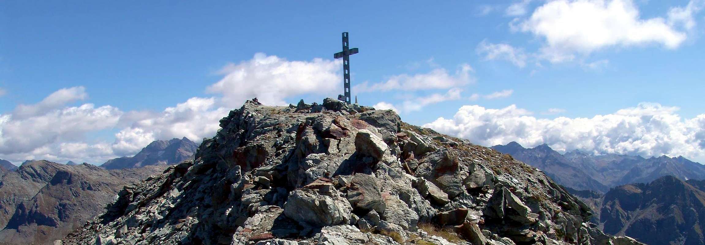
2) - Corno Bussola (+; 3.023m; EE/F+, a shorth passage equipped with chain; 3h'30/4h'00 from Estoul; 1h'45/2h'15 from "Baita Dino").
Corno Bussola (3.023 m) Avvicinamento dal Vallone dal Vallone di Palasina:da Brusson salire al Villaggio di Estoul (+; 1.818 m; ampio parcheggio con pannelli e varie segnalazioni) tramite la Strada Regionale; da qui, verso Settentrione con la poderale dapprima concomitante ai sentieri n° 5/4/105, verso i vari Alpeggi di Fenillettaz (1.840 m), il successivo bivio (1.882 m; segnale di divieto per i mezzi), Fontaine (1.903 m), Chanlochère (2.012 m), bivio 2.029 metri, Chavanne (2.107 m), le due alternative (2.103 m, 2.209 m) viciniori al Lago Litteran (2.226 m), bivio 2.231 metri. Da questo punto a Nordovest in direzione delle Alpi Chavanne (2.347 m) e Palasinaz (2.402 m) verso la
1) - "Baita Dino" (circa 2.435 metri; casa privata); dalla stessa, dapprima con sentiero n° 4/105 in un valloncello e lungo l'emissario e quindi presso la sponda Nord del Lago della Battaglia verso i Laghi Pocia e Lungo. Con sentiero n° 3C ad Ovest-nordovest al di sopra d'un promontorio detritico raggiungere il largo Colle Bussola (2.807 m); continuare a Nordovest sulla facile Cresta Sudest con sentierucolo sino al
2) - Corno Bussola (+; 3.023 m; EE/F+, breve passaggio attrezzato con catene; 3h'30/4h'00 da Estoul; 1h'45/2h'15 dalla "Baita Dino").
Gear
For Hiking or with snowshoeing also by ski.
Da Escursionismo o con racchette da neve oppure sci.
Difficulty
From F to (in winter for BSA= good skiers-mountaineers) F+.
Da F ad (in inverno per BSA o buoni sciatori-alpinisti) F+.
Camping
Camping Monte Rosa, Frazione Extrapieraz 186, Brusson - Tel. 0039.0125.300282There are no camping grounds in Estoul area.
Warning In Val d'Aosta, free camping is forbidden below 2.500 mt. Over 2.500m is allowed, from sunset until dawn.
Red Tape
No trek permit needed, no parking fees. 100% free.
Children refers to the set of objects that logically fall under a given object. For example, the
Aconcagua mountain page is a child of the 'Aconcagua Group' and the 'Seven Summits.' The
Aconcagua mountain itself has many routes, photos, and trip reports as children.
Parents refers to a larger category under which an object falls. For example, theAconcagua mountain page has the 'Aconcagua Group' and the 'Seven Summits' asparents and is a parent itself to many routes, photos, and Trip Reports.


 7614 Hits
 84.26% Score
 21 Votes