The page was successfully edited.

|
|
Mountain/Rock |
|---|---|
|
|
45.33141°N / 122.11286°W |
|
|
Trad Climbing |
|
|
Spring, Summer, Fall, Winter |
|
|
200 ft / 61 m |
|
|
Overview
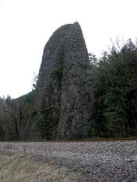 South Face
Twenty eight miles from downtown Portland (~3 miles east of Rooster Rock) and 50 yards from the eastbound lanes of interstate highway 84 stands a small, 120-foot tall basalt tower. Seen by vast majority of Portlanders as they zoom by at 70 miles per hour on the interstate, yet very rarely climbed, The Pillars offer a typical Gorge climbing “adventure”: mossy, loose, poorly protected and yet so fun. Also known as Speelyei’s Columns (see N. Dodge reference below), The Pillars are in fact a collection of three towers: the principle 120-foot free standing formation; Cigar Rock, a 30-foot tall pointy boulder right next to the interstate; and Pinochle Pinnacle, semi-attached to the rim wall. Though the rock is referred to as “basalt”, one should not conjure up images of beautiful smooth and solid columns with endless splitter cracks scattered in-between in their minds. No, this is Columbia River Gorge basalt: fist-sized chunks of volcanic crap held together by moss and dirt. All handholds and footholds are suspect and can pop off when you least expect them. Protection is generally unreliable.
Getting There
 Hike In
Take I84 to exit 28, Bridal Veil exit. Note that there is no exit from the westbound lane – turn around at Rooster Rock State Park exit 3 miles west. From here, two approach options are possible:
(1) Drive up the exit ramp road heading southeast for about 0.4 miles till you come to the historic Columbia River Highway. Turn right and follow it for about 0.7 miles to the Bridal Veil Overlook parking on the right. Park the car and hike 100 yards along the trail heading ~west. Leave the trail and hike left through the progressively thickening bushes. Cross a small stream and make your way down a loose scree slope. Your goal is to hike down to the railroad tracks without getting cliffed out. Once at bottom, hike west along the old overgrown railroad bed (no tracks) that runs parallel to the existing (and busy) railroad track till you come to the base of The Pillars. Approach time is about 20 minutes.
(2) Drive up the exit ramp road and make the first right (just after you go over the railroad overpass). Pass by the post office shack and continue driving the heavily potholed road running parallel to the tracks. Park before the road turns uphill away from tracks. Note that it’s not clear if this is privately owned – proceed at own risk. From where you parked, make your way down the thick, thorny bushes to a log crossing of a (occasionally raging) stream. The log “bridge” is right below the railroad bridge. Hike along the side of the track (on its south side) to the base of The Pillars (keeping a low profile is probably a good way to go). Have not done this approach in full.
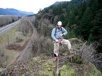
Easiest Summit Route
 Start
StartThe easiest means of reaching the summit of the principle Pillars Of Hercules formation is a single pitch line that starts on the east edge of the formation and on its south face. The route is a tad more serious (looser and more runout) than the South Face route on Rooster Rock.
East Route 1 pitch, 5.4, ~140 feet. As you approach the formation from the east, you will naturally come to a clearing at the foot of the southeast corner. Start by stemming up a shallow chimney formed by the main pillars and an adjoining 20-foot “boulder” on the right. Enjoy the moss. Continue up the 5.4 chimney (more moss and movable holds) for 70 feet till you come to a notch. Move onto the north face. Traverse a mossy ledge 15 feet west to a large tree on the north face (photo here). Continue up another mossy chimney for ~40 feet to the summit. Shirley saw a fixed piton here but I missed it. Belay from steel cable slung around….dirt and moss hump on the summit. Cheer up, this is also you rap anchor (here).
Descent: Double rope rap off (~120 feet) the summit anchor down the south face.
Gear: Couple long slings for slinging a rock horn and the tree. Set of cams from #0.75 to #3 Camalot.
Red Tape
 East Face
If you park at the Bridal Veil overlook, you need to have an Oregon State Parks permit and the park closes at dusk. Details can be found on the state parks page: here
The other approach option, has no red tape but not sure how legal it is.
Mountain Conditions

There is really no site/person/organization to give you climbing conditions per se, but check Troutdale, OR and Cascade Locks, OR for area weather forecast.
Camping
 North Face Rap
Closest legal camping options are at:
Ainsworth State Park.
More general information about area camping can be found here.
Information from peakbagger4’s Rooster Rock page.
External Links

Couple of photos from Wayne Wallace on his climb of the Pillars in '77, here.
Nice collection of Pillars photos: here. Note the historical shot w/o I84 present.
Routes Overview


In addition to the above-described East Route (I 5.4), Dodge also lists the following lines on the principle formation:
(1) North Face I 5.5
(2) North Face Variation I 5.5
(3) North Face Traverse II 5.6
(4) South Face II 5.8
(5) West Arête II A2
In addition, the collection of Pillars also includes:
(6) Cigar Rock. This is the 30-foot cigar-shaped pillar standing between the main Pillars cluster and the interstate.
(7) Pinochle Pinnacle. 100 yards east of the main Pillars cluster – a tower adjacent to a cliff. 2 pitches, 5.5.
Guidebooks
There are (or have been two – one is long out of print) two:
(1) A Climbing Guide To Oregon by Nicholas A. Dodge (ISBN 0-911518-33-9). Gives detailed descriptions for all six routes on the tower. Includes a topo of the north face routes. Long out of print.
(2) Portland Rock Climbs: A Climber’s Guide To The Northwest Oregon by Tim Olson (ISBN 0-9635660-2-4). Gives a single paragraph description of the Pillars and their easiest route.