Sentinel Point, 12,527 ft.
Class 3, with snow and ice
Distance (Round-trip): 6 miles
Elevation Gain: 2,800 feet
A significant winter storm was brewing for the first days of spring, so I decided to try something less committing for my last climb before winter officially came to an end. Doing so also allowed me the luxury of sleeping in a couple extra hours. I did not finally roll out of bed until five in the morning.
By eight o’clock, I was parked at the shut down Midland Terminal Railroad Tunnel, and ready to begin my hike. I followed the trail toward Horsethief Park and made excellent time because there is not much elevation gain in this section. There was some snow, but it was already packed down from other hikers. It would have been nice to visit the rest of Horsethief Park, but with uncertain weather forecasts I decided I better focus on my objective first: Sentinel Point.
![]()
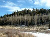
Sentinel Point from Horsethief Park
I was alone in the mountains all day, and the weather turned out to be mostly sunny. Still, I could see darker clouds to the west, along with more and more virga as the day progressed.
I enjoyed a pleasant stroll back the almost entirely-flat Horsethief Park Trail. I felt almost spoiled to be able to get to such a peaceful and quiet place with such little effort. The flat area looked like it would be marshy in the summer, and there were a couple small ponds that were also frozen over. Near the end of the main trail, there are a couple large beaver dams. Looking past them I could see the aspens, then the thick evergreen forest, and on top of it all, the conical Sentinel Point. I could already see how this solitary summit got its name.
As I reached the terminus of the main trail, a lesser trail continued into the thick evergreen forest. Fortunately, there were partially-covered snowshoe prints that I was able to follow, and before long I began to see cairns as well. This trail was steep at places, but made for easy progress.
I slowed down significantly near timberline, mainly because I began post-holing in the softening snow. The snow was getting deep here, and the sun was working against me. I had snowshoes on my back, but was too stubborn to stop and put them on.
My main problem was actually route-finding at this point. I had come to the beginning of a boulder field, and I contoured to the left, following the snowshoe prints and the route instructions. As I forged upward, I looked again at my map a couple times, and realized this trail was leading to the large drainage to the north. That would still get me where I was going, but it was out of the way, plus I did not want to spend the whole time post-holing up the drainage.
![]()
Entering the Boulder Field
Instead, I started picking my way up the boulder field. This was slow and tedious work, as the boulders were indeed just that: boulders. Huge boulders were strewn about everywhere, with deep and unreliable pockets of snow between them and covering some of them. I was, in essence, boulder-hopping, though that is a trite term for the strenuous exercise I was performing.
A couple times, I considered angling back to the north and meeting up with the trail again. The direction I was heading was taking me straight up to a series of snow and ice-covered cliffs. However, after stopping to eye the looming cliffs for several minutes, I decided I had found one possible weakness.
![]()
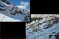
The Crux Before the Saddle
Besides the summit scramble, this ended up being the crux of my route, but it worked. I slogged through deep snow, then kick-stepped on hardened snow, to arrive at the base of what looked like a weakness in the cliffs. There were maybe fifteen feet of very steep terrain leading to a ledge system. At my first up-close glance, the grass and steep rock covered by a thin layer of snow and ice seemed to not offer enough options for an ascent. I almost considered turning around, but then decided to knock some of the snow away and see if I could discover any unlikely holds.
Surprisingly, I did find some holds. They were small, but I carefully tested each one. Before I knew it, I was halfway across the difficulty. At this point, I found a nice solid jug above me, with which I was able to pull myself onto the upper ledges. I was past the crux, but I now had to take every step carefully, traversing steep snow-covered ledges, which dropped off to cliffs below.
The snow was annoyingly fickle, and I had to alternate between post-holing (sometimes more like swimming), kick-stepping on the solid stuff, and breaking through thin layers to slanted boulders. The latter posed the most danger, as I did not want to go into a slide. I had been negligent in not taking my ice axe or crampons on this day. Still, I took every step carefully, and before long the slopes relented.
Before long, the ledges widened and I easily walked up grassy slopes to the saddle, where I now had great views of the summit cone of Sentinel Point. Past the saddle, I hiked up steepening slopes toward the east face of the mountain.
I found some cairns, but as I approached the mess of gargantuan boulders near the top, I had no idea which one was the true summit. The weather still looked stable enough, so I figured I had some time to explore.
With a lot of scrambling, I made it to the top of each of the high points, having to retreat almost every time to find a different route up to the next boulder. The final choice was at last the correct summit. I knew, because I found a USGS marker there when I arrived. However, I did not find a summit log. I had arrived at this mess of red boulders some time around noon, and it was about half an hour before I reached the correct summit. Negotiating all the awkward rock formations was a lot of fun.
It was somewhat windy there, but not bad at all for March. I sat down in a kind of natural “lounge area” right next to the summit, and enjoyed the view. I could the summit of Pikes Peak, along with some cars on the Pikes Peak Road. I could also see storms brewing to the south and west, and they appeared to be getting closer. I took numerous pictures and then hastily headed down, beginning my descent around 1300.
I knew the route I had ascended was not going to be my route down. Instead, I angled straight downhill into the woods from the saddle. As soon as I entered the trees, I found surprisingly deep snow. A couple times I found myself wading downhill. Fortunately, it was steep enough that I was able to just keep putting one foot below the other and I continued to make progress.
![]()
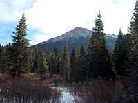
The Summit and Pikes Peak
Another surprise was more cairns. I wondered if perhaps this was the standard route to get to Sentinel Point. If so, I am glad I followed the other trail; post-holing through snow multiple feet deep would have been a nightmare going uphill.
I made it a point to angle north, so eventually I would return to my ascent path. I met up with my footprints down at the lower boulder field, where I had originally contoured to the north. From there the going was easy, though sometimes jogging was the best way to avoid slipping on steeper portions of the trail.
As I entered the open, flat, marshy area, dark clouds filled the sky. Moments later, flurries began, and before long it was snowing hard. In fact, it was already laying as I made my way back into the woods for the final stretch of trail to my jeep.
![]()
Morning Sun, Afternoon Blizzard
I passed one couple, the only people I saw all day, as I neared the trailhead; they were apparently just out for an afternoon stroll.
I arrived at my jeep at 1500. At this slightly lower elevation, there were only some flurries, but all the surrounding peaks were obstructed by dark clouds of snow. I encountered some more snow on my drive home, but nothing that was yet a hazard to driving.
At least the weather held off long enough to allow me a great day in the mountains. I even got to be the “acting sentinel” for about an hour, overlooking Horsethief Park and Pikes Peak from one of the coolest summits I have visited in Colorado.
© 2006, Brad Snider


Comments
Post a Comment