
-
 7853 Hits
-
 71.86% Score
-
 2 Votes
|
|
Route |
|---|---|
|
|
45.91139°N / 6.91229°E |
|
|
Mountaineering, Trad Climbing |
|
|
Spring, Summer, Fall |
|
|
Most of a day |
|
|
IV+/V- |
|
|
7 |
|
|
Overview
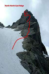
The North-North-East Ridge of the Aiguille de l'M is one of the most popular routes of the Aiguilles. For many people this is an introduction to Chamonix rock-climbing. And for good reason. The climb consists of a succession of everything Chamonix-rock has to offer. Slabs, cracks, chimneys, walls, ledges, a letter-box.But this isn't just a route for newbee's to Chamonix-rock. It is also perfect to get back into shape after a winter of ice-climbing or for a short day, when the weather isn't all that.
First ascent: Mme M. Damesme, F. Batier, M. Demesme, J. Morin
Date: 25 August 1945
Vertical height: 160m (2680m - 2844m)
Today's route: Contamine's party, 24 August 1948
So, let's enjoy this classic!
Getting There
The foot of the face can be reached easily in 2h either from Plan l'Aiguille of Montenvers.From the Plan de l'Aiguille station follow the path north (downhill) to the Chalet du Plan de l'Aiguille. From here follow the trail Grand Balcon Nord towards Le Montenvers. After apr. 2,5 km's take a narrow path to the right. From this point you can clearly see the Aiguille de l'M.
From Montenvers you reach the same point by taking the the Grand Balcon Nord wich starts at the Montenvers hotel. Go around Signal Forbes (not over it) en once you are around go left up the narrow path.
From here follow the path uphill. Don't follow the path all the way, but work your way up on the left side of the scree-slope and so reach the base of the ridge at a cwm. From here you can see the entire ridge.
 |
Map: Institut Géographique National (IGN), map number: 3630 OT Chamonix (1:25000)
Route Description
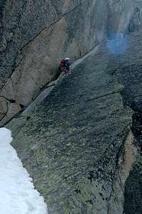
How to get up:Start up a slab wich is steep at first, but the angle eases after a meter. Climb futher over these slabs (IV,V-) and after two ropelenghts reach a huge terrace. From here climb the sloping crack (IV, V-). On the left side of the crack you will find some fixed gear. You reach a good stance. Climb the dièdre and traverse left to another stance. Traverse left over a ledge for apr. 5m and then go straight up through some vertical groves (IV+).
- Then bear right and go through the letter-box (III). Continue up large blocks to reach the summit (II, III).
- Or go left (IV+) and follow a crack (III) directly to the summit.
 |
 |
How to get down:
From the summit descend down the North-North-East Ridge for a little distance before slanting down right towards the Col de la Bûche (2785m). Go down through the scree-couloir (stonefall). First stay on the left bank (facing down), then the right bank, finally return to the left bank where there are ladders to descend to the Nantillons Glacier. From here you can go back either to Montenvers, to the Plan de l'Aguille or walk down to Chamonix.
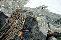
Essential Gear
Rope (50m), 5-6 runners, some nuts and friends and possibly crampons for the approach.External Links
EditingSome images
 |
 |
 |
|
 |
 |
 |
 |