
|
|
Mountain/Rock |
|---|---|
|
|
48.03300°N / 88.8°W |
|
|
Keweenaw |
|
|
Hiking |
|
|
Spring, Summer, Fall |
|
|
1394 ft / 425 m |
|
|
Overview
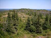
The Greenstone Ridge forms the geologic backbone of one of America's least visited National Parks...Isle Royale. This half-million acre piece of heaven on earth is located in the far northwestern corner of Lake Superior. Isle Royale is a gem. The only way to get around the island now is the same way you had to get around it 300 years ago...by foot or boat. The island is rugged also. The island is composed of a series of ridges that run the length of the island. In between these ridges are areas of swamp and muskeg. Sound inviting?The Greenstone Ridge is the longest and highest of these ridges. It gets its name from the greenish stones that are commonly found along it. It runs the entire 45-mile length of the island and is anything but smooth. A few notable peaks along it include Mt. Franklin(1080’), Mt. Ojibway(1136’), Mt. Siskiwit(1205’), Ishpeming Point(1377’), and Mt. Desor(1394’). The ridge top is quite open in places, particularly along the northeast half of the ridge. The trail between Mt. Franklin and Ojibway is especially scenic.
FOR A TRAIL MAP OF THE PARK CLICK HERE
The Ridge, The Trail, & the Peaks
The Greenstone Ridge and its namesake trail are the crown jewels of Isle Royale National Park. The trail runs 42.2 miles from where the Greenstone Ridge rises out of Lake Superior in the east at Lookout Louise. The trail then heads west over the Greenstone’s exposed ridges, through deep woods, across swamps, and past pristine lakes. The Greenstone Ridge drops back into Lake Superior not far from Windigo at the islands west end. Most hikers make the journey in 3-5 days. The following is a (very) brief description of the ridge and trail from east to west.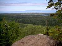 Mt. Franklin
After departing from Rock Harbor the quickest way to the Greenstone Ridge is to head west on either the Rock Harbor or Tobin Harbor Trails and then up the Mt. Franklin Trail to the top of the ridge just east of Mt. Franklin.
From here it is 5.1 miles east, along the Greenstone Ridge Trail(GRT), to the end of the Greenstone Ridge at Lookout Louise. This section of the GRT is one of the most scenic and, strangely, the least used. East of Mt. Franklin the forest thins out and you soon break out into the open. There are stunning views to the north and south. Flora in this area consists of small shrubs and grasses. At Lookout Louise, the eastern terminus of the GRT, you are treated to beautiful views of the seldom-seen eastern end of Isle Royale. There is nowhere to go from Lookout Louise without a boat so to continue west you have to make the 5.1 miles back to Mt. Franklin. Good thing its scenic!
Back at the junction with the Mt. Franklin Trail the Greenstone Ridge Trail heads west and soon breaks out onto the ledges of Mt. Franklin(1080’). The views from Mt. Franklin are stunning. The panorama includes Lane Cove and the rugged north shore and, beyond, the cliffs of Sleeping Giant are clearly visible on the horizon almost 50 miles away. Continuing west the trail alternates between woods and open, rocky ridge. Lake Superior and the distant Canadian shore are visible to the north and Rock Harbor is to the south. After 2.5 miles the trail ascends to the summit of Mt. Ojibway(1136’) and its fire tower. The tower is closed but if you hit it at the right time of the day a friendly ranger might allow you up top for a stunning 360-degree panorama of the island from one of its highest points.
 Mt. ojibway
From Mt. Ojibway the trail follows another mile or so along mostly open ridge after which the scenery becomes increasingly wooded. The trail begins a number of small gains and losses of elevation and continues this way until, 5-ish miles from Mt. Ojibway, it drops 300 feet off the north side of the Greenstone Ridge to Chickenbone Lake. The GRT heads between Chickenbone Lake and Lake Livermore for 2 miles and then heads west into the heart of Isle Royale.
West of Chickenbone Lake the Greenstone Ridge Trail climbs steeply again out onto the open, rocky ridge. Three miles from Chickenbone Lake the trail passes just south of the summit of Mt. Siskiwit(1205’) and then drops back into the woods and then gains the open ridge climbing up and over numerous rocky outcrops. After a couple miles the trail crosses a enormous bog following wood planks over the wet terrain. Six and a half miles from Chickenbone the GRT climbs the Greenstone Ridge steeply out of the bog to the open ridge again. The trail is more wooded now but still occasionally affords fine views. After a few miles you climb to the second highest point on the island, Ishpeming Point(1377’). Ishpeming Point was, at one time, an open bald but is now heavily overgrown and without views.
 The Greenstone Ridge
West of Ishpeming Point, for a couple miles, the Greenstone Ridge Trail is surrounded by woods but, without fail, it breaks out into the open before gradually dropping the 300+ feet down to the relative lowlands south of Lake Desor.
For many hiking the Greenstone the section from Lake Desor to Windigo is the final stretch. The ridge doesn’t go easy on them. Just west of Lake Desor the Greenstone Ridge along with the GRT rises steeply to the highest point on Isle Royale, Mt. Desor(1394’). Unfortunately, like most other peaks on the west end of the ridge it is heavily wooded. There are no views to reward your climb. The trail continues the next few miles through a mixed forest of maples and pines and the ridge itself stays above 1200-1300’ much of the way. The last 5.5 miles miles of the GRT (heading west) is mostly downhill as the Greenstone Ridge drops gradually into Lake Superior once again at Windigo.
Getting There
Getting to Isle Royale is half the fun. You can’t just hop in the car, or boat, and go. There are only two ways to get to Isle Royale, by boat or seaplane.By Boat : There is regular ferry service to Isle Royale from Copper Harbor and Houghton in Michigan and Grand Portage in Minnesota. The shortest trip is aboard the Voyager II or Wenonah from Grand Portage to Windigo Harbor on the west end of the island, its about 3 hours. The Voyager II does circumnavigate the island and makes various stops, including Rock Harbor. Bear in mind though that this will cost you (a lot) extra. The Ranger III sails from Houghton to Rock Harbor, on the east end, in about 6.5 hours. Your final option, the Isle Royale Queen IV, takes about 3.5 hours to cross from Copper Harbor to Rock Harbor. In short, boats from Michigan access the east end of the island and boats from Minnesota, the west end.
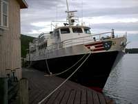 Isle Royale Queen IV
By Seaplane: Another option for visiting the island is by seaplane. There is regular service during the summer out of Houghton, MI. The planes service both Rock Harbor and Windigo.
If you happen to have your own boat (or seaplane) you can go anytime but day-use fees still apply. Visit the National Park Page for more info.
"Green" Tape
I call this section green tape because a visit to Isle Royale and the Greenstone doesn’t come cheap. You’ll shell out between $100 and $250 dollars per person just to get there depending on which mode of transportation you take. On top of that there is, in 2006, a $4 per day day-use fee. You’ll need at least a week to get around even a part of the island so your looking after taxes at $150-$300 per person. This isn’t to scare you off, trust me its WORTH EVERY PENNY.Camping
Much of Isle Royale is a Wilderness Preserve. Camping is only allowed at established sites. There are 36 established campgrounds on Isle Royale and the surrounding islands. Of these, 8 are found on or near the Greenstone Ridge. There are three types of sites on the island and what is available varies by camp. There are individual sites(1-6 people), group sites(7-10 people), and shelters(1-6 people). Below is a brief description of each camp, from west to east. Backcountry Shelter
Lane Cove: Because you can only access this campground from the Greenstone Ridge I listed it here. It is 2.5 miles off the Greenstone on the north shore of the island via the Lane Cove Trail. It has 5 (small)sites, no group sites, and no shelters. After visiting the island I found out it has a reputation as the buggiest camp on the island.
 Lane Cove
Daisy Farm: This is the biggest and busiest campground on the island. Most backpackers departing from Rock Harbor make the 7.1 mile bee-line to this camp their first day. It is a nice camp and is only 1.5 miles south of the Greenstone via the Mt. Ojibway Trail. It has 6 individual sites, 16 shelters, and 3 group sites. It also has a boat dock.
Chickenbone East: This camp sits above Chickenbone Lake only .1 miles from the Greenstone Ridge Trail. Chickenbone East is 12.7 miles from Rock Harbor. Its small, and has 3 individual sites, 1 group site, and no shelters.
Chickenbone West: I love this campground. It is 14.7 miles from Rock Harbor. Many sites are right on the shore of Chickenbone Lake and the rest at least have views of it. This is also, I hear, the best campground in the eastern part of the island for seeing moose. We saw two wade out into the lake to eat the night we stayed. It has 6 individual sites, 3 group sites, and no shelters.
 Daisy Farm
Hatchet Lake: This campground is perhaps the most remote of any camp along the Greenstone Ridge Trail. It is 19.7 miles west to Windigo and 22.6 miles east to Rock Harbor. The camp is about a half mile off the Greenstone via the Hatchet Lake Trail. Moose are a good possibility here. It has 5 individual sites, 3 group sites, and no shelters.
Lake Desor South: This camp is .4 miles north of the Greenstone Ridge Trail on the south shore of Lake Desor. It has 7 individual sites, 3 group sites, and no shelters.
Island Mine: Island Mine Campground is located just off the Greenstone Ridge Trail 6.5 miles from Windigo. It is one of the few campgrounds on the island that is not on a major body of water. There is, however, a small but reliable stream that runs nearby. There are 4 individual sites, 2 group sites, and no shelters.
 West Chickenbone
Washington Creek: This is the second largest campground on the island and is located 0.3 miles outside Windigo near the west end of the Greenstone Ridge Trail.
Keep in mind all campground sites are first-come-first-served. You must fill out an itinerary when you arrive on the island but this doesn’t guarantee a specific site. As you may expect, shelters usually go first.
When to Go
Isle Royale National Park is open from April 15 through the end of October. The best times to go, in my opinion, would be spring or fall. In spring you are treated to more open views before the trees leaf-out and, if you go early enough, you beat bug season. September and October I would imagine are hard to beat with the fall colors and cooler temps. Be warned though, this is northern Lake Superior, cooler temps can mean 20 degrees and a foot of snow.I, like most others, have only visited in the summer. Bug season generally runs from May to August. Temps are usually in the 70’s but can be 20 degrees either way of that figure. The Greenstone Ridge can be a nice place to be when a nice summer breeze is rushing over the ridge but it is also very exposed in places. Be prepared for rough weather when traveling these open ridges.
External Links
Isle Royale National Park - the official NPS websiteIsle Royale Info - a private site with TONS of info. Maybe better than the official NPS page!
More Isle Royale Info - another private page with good info on Isle Royale
Isle Royale Queen IV - ferry from Copper Harbor, MI
Ranger III - ferry from Houghton, MI
Wenonah & Voyager II - ferries from Grand Portage, MN
Copper Harbor, MI - Info page for Copper Harbor, MI
Houghton, MI - Official page for the city of Houghton, MI
Grand Portage, MN - Info page for Grand Portage, MN
Upper Michigan Weather - NWS Office in Marquette, MI
Minnesota Arrowhead Weather - NWS Office in Duluth, MN
DWhike's Adventures - Shameless self promotion...come visit my website for more pics of Isle Royale and other places that I have wandered off to in recent years...

