Overview
This trip report is finally done (May 16, 2006)!
Mileage - about 37 miles (59 km).
When - September 12 to 15, 2003
This is a
clasic loop hike with constantly changing and always new landscape views the entire trip.
A brief route description starting at the bridge at the East Fork Blacks Fork TH ---> up the slopes and across the tundra-like terrain of Bald Mountain, down to Smiths Fork and Lower Red Castle Lake, up past Smiths Fork Lake and near East Red Castle Lake, up and over Smiths Fork Pass and down into the Yellowstone Drainage with view of Kings Peak, connecting with the Highline Trail west over Tungsten Pass to North Star Lake (not a tree for miles...), up and over 12,300 foot Porcupine Pass and into jaw-dropping Oweep Basin in Lake Fork Drainage, past Squaw Pass Lake and up Squaw Pass where the views just keep getting better and finally down into the Little East Fork Blacks Fork. Then, to the car, with literally not one part of any trail walked on twice.
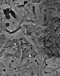
![Aerial Photo of the Red Castle Area]() Aerial Photo
Aerial Photo
The elevation table (and graph) is a very close representation of our actual route. We double-backed to the bridge over Smiths Fork instead of bushwacking southeast of Lower Red Castle Lake and cut off maybe a mile or less around Squaw Pass Lake but other than that, spot on. The elevations were taken from reviewing National Geogrpahic's Trails Illustrated High Uintas Wilderness map and the Probst brothers' classic book "High Uintas Backcountry". This is a must have.
Highlights
- beautiful / jaw-dropping high alpine scenery
- surprising solitude just about the entire trip
- high winds in Garfield Basin (the tent was fully tied down)
- sunny every day, highs in the low 50's, lows to mid teens
- no bugs (I hate them things...).
Gettin' There
These are my somewhat "loose" trailhead directions encapsulated in a thrilling travel story. Okay, not so thrilling, but hopefully you'll identify.
Tim and I left Park City at about 7am on a Thursday and drove the 20 minutes to Kamas, the "Gateway to the Uintas". A previously sleepy town nestled below the western terminus of the Uinta Range, it had just found the need for its first stoplight a few years ago. I never thought I'd see the day come. In ten years there'll be two Starbucks and a Pizza Hut I bet.
![Early Season Snowfall]() View from Bald Mountain Pass
View from Bald Mountain Pass
Sep 10 saw Utah get hit with a sizable snow event which dropped up to a foot in the 9,000 foot elevation range in the Wasatch as witnessed by our drive up to Alta in the late afternoon. The Western Uintas got maybe 5-6 inches of snow. I was a little concerned because that is close to where we were planning to hike. Luckily, the snow never truly made the leap east of Hayden Fork. The pic at the left, taken from Bald Mountain Pass, shows the very early season snowfall.
Highway 150 begins at Kamas and winds its way through through Utah and terminates in Evanston, WY. The road ranges in elevation from about 6,200 feet in Kamas to 10,700 feet at Bald Mountain Pass. Be careful of free range livestock, particularly at the lower elevations, as they will hang out in the road for no apparent good reason and are expensive if you hit and kill one (for your car, medical bills, and the cow, for which you will need to pay).
From Bald Mountain Pass, the road heads generally north and east, leveling out for about three miles after which it crests the almost unnoticeable Hayden Pass (Highline TH) at 10,300 feet. From the pass, the roads shoots almost straight north, heading down several thousand feet toward the North Slope area. The views are dramatic all the way through; the Hayden Peak Overlook just east of the pass is particularly striking.
![Tokewanna Peak]() North slope of Tokewanna Peak
North slope of Tokewanna Peak
A mile or so past the Bear River Ranger Station on the Mirror Lake Highway is the North Slope Road (NSR). It is the only east-west road on the north slope of the Uintas. The road was in very good condition although I think it had deteriorated somewhat over the summer season. We drove approximately 22 miles on the NSR before our turn-off at the East Fork Blacks Fork Road. (About four miles prior to this road is the West Fork Blacks Fork Road that leads to the trail to Deadhorse Lake.) After the right turn onto the East Fork Blacks Fork Road, it was an easy and flat five mile drive to the main trailhead.
About 1/2 mile before the trailhead is the basically undeveloped Cache Trailhead. We could have parked here but for two reasons we did not - 1) there is no bridge crossing the river at this trailhead and 2) there is no decrease in hiking mileage (the 1/2 mile you save on day one must be walked on day four, and honestly, who'd want to walk farther on the last day?).
The main trailhead sits below Bald Mountain to the east and has several picnic tables and bathrooms. The carpark can probably fit 25+ cars, more than enough room based on the two times I have been there.
It was about a three-hour trip from Park City including the stop on Bald Mountain Pass, which maybe was about 10 minutes.
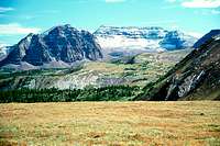
Day 1 - Lower Red Castle Lake
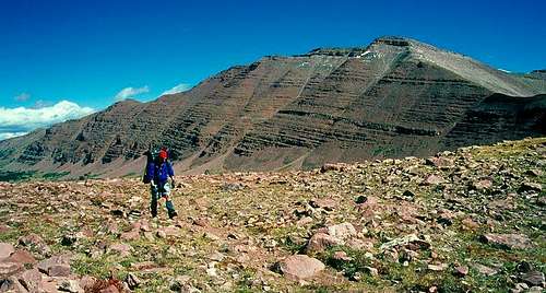
![Red Castle Peak]() Resting on the highpoint (11,600 feet or so) of the Bald Mountain Trail
Resting on the highpoint (11,600 feet or so) of the Bald Mountain Trail
We left at about 11:30am from the trailhead, walking past the main sign along the dirt road and down the steep decline to the river. After crossing the bridge we headed left (north) and found our way about a half mile to the Bald Mountain Trail. There is apparently a trail from the bridge but I think we turned left too soon and had to bushwhack a little. The trail up Bald Mountain actually originates at the Cache TH which is located about a half mile north of the main TH.
The Bald Mountain Trail climbs about a 1,000 feet, switchbacking across western and northern exposures, providing some great views of Mt. Lovenia to the south.
We crested the forested top and arrived at a scree slope through which the trail is quite hard to find. From here it is a looong way to the top of Bald Mountain as several false summits made me wich I had trained a little harder. Coming from about a 600 foot elevation in Saint Paul, MN and Detroit, MI the day before, walking at these elevations is tough. The trail actually misses the top by about 200 feet but still gives you incredible views of the surrounding wilderness. Wyoming, Mt. Gilbert, Henry's Fork Peak, Red Castle, Mt Wilson, Squaw Peak, and a host of other peaks in the Little East Fork Blacks Fork Drainage are perfectly aligned directly in front of you.
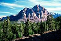
![Gilbert Peak as seen from the...]() Mt Gilbert
Mt Gilbert![Bald Lake on Bald Mtn]() Bald Lake
Bald Lake![Wilson & Red Castle Peaks]() Red Castle & Wilson Peaks
Red Castle & Wilson Peaks![Red Castle Peak]() Red Caslte Peak
Red Caslte Peak
Seldomly visited Bald Lake, nestled about 400 feet lower than the trail, looks to be a beautiful camping spot for the tired or those who got a late start. The water in this lake is fed by deep snow created by wind around the high slopes on its west side.
The trail drops about 200 feet to 11,300 feet as it levels out across the next mile or so. After topping a small rise at the southern end of this high alpine tundra, Red Castle and Mt Wilson loom over the view in front. The quality of my pics of this area was hampered by the time of day (2-3pm) and the direction of view (south).
At the time, I was beginning to get a little tired but we had only completed about six of our intended 10-11 miles to Lower Red Castle Lake. Tim, on the other hand, cruised across the tundra at over 11,500 feet. As we found out later on the trip, two can play at that game.
After dropping about 500 feet through steep switchbacks, the trail continues east until it splits, one continuing east and the other turning right (south). Follow the south trail. I noticed that the path more heavily traveled is the one you want so this should be an easy decision. The trail then winds through a forested section with several good campsites near the trail in partially open areas. It does become difficult to find the trail in spots but using the "if it looks right, it probably is" method worked fine.
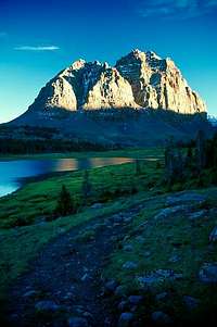
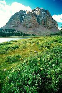
The trail joins the East Smiths Fork Trail about a half mile below Lower Red Castle Lake. Continue on the mail trail heading south to reach Lower Red Castle Lake. About five minutes after the Bald Mountain - East Fork Smiths Fork trail junction, the East Fork Smiths Fork Trail turns left (east), crosses a bridge, and continues south and up to East Red Castle Lake, Smiths Fork Lake, and ultimately, 11,900 foot Smiths Fork Pass. This is the way we traveled the next morning after returning from camping at the lake.
![Red Castle Peak]()
The sheer beauty of the Lower Red Castle Lake area was only matched by my frame of mind - jagged, cold, and far from any rational thinking probably brought on by a minor case of altitude sickness. This resulted in getting only two pics of one of the most gorgeous sunsets I have ever witnessed. At the time, nothing mattered except food and sleep and not necessarily in that order. Our campsite, the first one as Lower Red Castle Lake is approached, was about 50 feet off the trail and had a very soft pine needle cushion for the tent.
After dinner, we saw two animals one rarely sees. The first was a huge bull moose we watched amble from far away to within about 200 yards. It watched us as intermittently after it caught our scent; not sure if it was the scent of our food or our BO. His waddle was huge, maybe 30 inches long. The bushes and stumps in the swampy meadow below us was getting scraped by his antlers. It was mid September so the rut must have been getting very close. The second was an owl. I am not sure what kind because it was almost dark; it swooped down maybe 15 feet past us and then perched itself on the very top of a 20 foot tree. What was amazing was we did not hear a thing - not a flutter.
Day 2 - North Star Lake
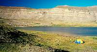
![Smiths Fork Pass]() The northern side of Smiths Fork Pass with Mt Powell overlooking the way
The northern side of Smiths Fork Pass with Mt Powell overlooking the way
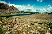
The morning began in a rather ominous tone, with dark clouds swirling over the high peaks and thick fog surrounding the basin, each one taking turns. At about 8:30am it all burned off leaving us with perfect weather - sunny with a few high clouds and about 50 degrees. After a quick walk to lake for some pictures, we ate, packed up, then continued back down the trail (north) about 15 minutes to the East Fork Smiths Fork Trail Junction.
We we made a right to walk over a solid bridge (one of the few you will see in the wilderness area), and continued south and south-east to Smiths Fork Pass. The view south into the upper reaches of the drainage is impressive, with a large stream-fed meadow as the foreground. Very pretty. This is this page's primary image id.
The trail continues through intermittent forest and small meadows, generally climbing gradually for about 90 minutes. The maps over which I had scoured indicate a trail junction below Mount Powell right in the main part of this drainage - the trail in question apparently comes from the north as a shortcut from the East Fork Smiths Fork Trailhead. I saw none although Tim thinks he did. Albeit a minor one, that is one of the problems in the Uintas - trails shown on maps that are not where they actually are.
From the east now, Red Castle looks massive but less imposing than from the north and west. East Red Castle Lake is nestled out of sight right below the eastern talus slope of Red Castle. This lake is about a 10 minute walk west from the point at which treeline is reached. The trees begin to show signs of distress, stunted and gnarled at this 11,300 foot elevation. We did not see that lake but continued for about another 10 minutes to Smiths Fork Lake.
![Smiths Fork Lake]() Smiths Fork Lake Panaorama
Smiths Fork Lake Panaorama![South Kings Peak as seen from...]() South Kings Peak
South Kings Peak
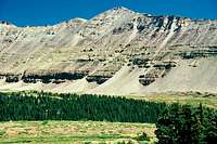
The terrain from here on up is quite rough with rocks strewn about everywhere. The wind had picked up and now was blowing hard, maybe gusting to 30-35 mph. Thankfully it was still sunny. We huddled in the intense wind above the lake, snacked, and continued on, pushing on to crest the 11,900 foot Smiths Fork Pass. On the way up I took two very good pics of Tim hiking below me. He was feeling like I felt the previous day - tired.
The pass, located on the Uinta crest which stretches 150 miles east-to-west, is smooth and large. It looks like a small sub-division could be built on it if it were not for the fact that the nearest road is about 13 miles away. The Uintas are the only east-west arranged mountains in the continental US. In fact, the only other east-west range in North America is the Brooks Range in northern Alaska. So, this pass led us to, what else, beautiful views of the north and south slopes, with East Fork Smiths Fork to the north and the upper reaches of the Yellowstone Drainage to the south. The east side of Wilson Peak is visible to the west.
From the pass we headed south into the Upper Yellowstone Basin, connecting with the Highline Trail in about three miles. Half-way down the gentle slope (if going up this may not seem too gentle in some spots) Kings Peak and South Kings Peak make their appearance to the east. The 2,500 foot slopes riddled with huuuuuuge cliffs ending on the relatively flat basin floor make for an impressive vista.
![Tungsten Pass & Lake]() Tungsten Pass
Tungsten Pass
Our trail continues west (right) on the Highline Trail while the trail we were just on continues down into the Yellowstone Drainage for about another 13 or so miles until a trailhead. Our objective though is North Star Lake, high in Garfield Basin to the west. So, after filling up at the stream near the junction, we head west to Tungsten Pass.
It takes about an hour to reach Tungsten Pass. On the way we encountered a very wet area on the shelf just below the pass. This was September so in mid-summer this place must be very hard to get through without getting wet. Not to mention the swarming of mosquitoes...
![Garfield Basin]() Garfield Basin
Garfield Basin
Tungsten Pass, as compared to other passes in the Uinta's, would be considered to be among the "minor" variety. While there exists no steep ascent or descent to the 11,500 foot pass, the views are still A-1, albeit different than others. What we saw when looking into Upper Garfield Basin was extreme desolation - no trees, few bushes, just short grass and rocks. Lots of rocks. The peaks surrounding this basin rise no more than 900 feet from the two main lakes that exist here - Tungsten Lake and North Star Lake. This pass cuts through a minor ridge that begins at Wilson Peak, travels south through Tungsten Pass and up to Yellow Peak. As such, I believe Upper Yellowstone Basin and Garfield Basin are both part of the Yellowstone Drainage.
Ten minutes below the pass lies another trail junction, that of the Highline Trail which we were on, and the Garfield Basin Trail, arriving out of, where else, the lower reaches of Garfield Basin. There is a weathered sign here, propped up several rocks. It is 2:45pm so we decide to push on to North Star Lake, just another 45 minutes west.
![North Star Lake]() North Star Lake
North Star Lake![Oweep Basin]() At the bottom of west side of Porcupine Pass looking across Oweep Basin at Cleveland and Squaw Peaks
At the bottom of west side of Porcupine Pass looking across Oweep Basin at Cleveland and Squaw Peaks
By now the wind was really blowing hard. Our thought was to find a place out of the wind. The problem was, there was no place out of the wind. Not a tree for several square miles. We walked up to North Star Lake and happened upon a table built of rocks about 20 feet from the shore. If it had not been windy we would have stopped as it looked comfortable. We pressed on to the south western shore where there was about a 10-12 high 200 foot long foot moraine surrounding it. We set up camp below that moraine and near the shore. Thanks to Tim, we tied down the tent and hoped for the best.
Day 3 - Little East Fork Blacks Fork
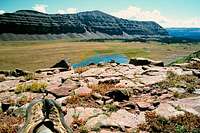
Each day we broke camp a little later; this day was no exception as we left North Star Lake just after nine AM for the slow but steady climb up Garfield Basin to the base of Porcupine Pass. The terrain was stark, unforgiving, and utterly void of anything but short grasses and rocks. Line of sight travel was a) particularly easy and b) necessary as the trail dashed in and out of existence for the two miles to the pass. Large cairns dotted the way but even they were difficult to spot from a not too far away distance.
![Squaw Pass & My Feet]()
At about 20 minutes, the climb up Porcupine Pass was quick although the 12,300 foot elevation made it seem like 40. Just when you think you have seen it all, cresting this pass gives one an awe-inspiring panorama of the Oweep Creek Basin in the Lakefork Drainage. Words cannot describe and pictures cannot truly capture the grandeur of the scene that awaits the tired hiker up here. The entire upper Lakefork Drainage unfolds 1,000+ feet below, sprawling westward to Cleveland, Squaw and Explorer Peaks.
Be careful on the way down (or up) the west side of Porcupine Pass. Guidebooks indicate and resources I have used for itinerary scouting mention that this trail is poorly maintained. "Sketch-ball" is what I'll call it. They are correct as carefully placed feet are of paramount importance. For those who have climbed Deadhorse Pass 10+ miles to the west, this is in much worse condition.
Once off the pass we traveled for about 2.5 miles making extremely fast time practically jogging through the basin. To the left was a 1,500 foot high ridge that stetches for four miles, lining the basin with precipitous cliffs clinging to the side. The rock walls reminded me of sentinels keeping watch over their majesty. Anyway, to the right stood reddish colored rock walls just a high but not quite as pretty due to their rounded nature.
While the trail continued another mile or so west, we cut cross-country, around Squaw Pass Lake, and ventured straight up the mountain side to meet with the Squaw Pass Trail heading up to the pass. Normally, I would have stayed on the main trail as my luck with very steep "off-piste" scrambling is not exemplary. But, Tim's great binocs helped us scope the goat path around the lake and our path up the mountain side. I reached the trail first and had another 15 minutes until the pass.
Remember when I wrote "just when you think you have seen it all"? Well, I had not. The view north into the Little East Fork Blacks Fork Drainage was again breath-taking, even more so because one great guidebook I had read mentioned that this drainage was "ugly" as compared to the rest of the range. True, the lower elevation trail was deep in the forest but the view from the top (and the next five or so miles) was beautiful.
We rested on the pass for about 30 minutes; it is perfectly flat and the two big cairns marking the top provided much-needed support. It was here that we saw the first two humans since we left the TH, a couple on their way peak-bagging for the next five days. Seeing them was strange as it had been almost three whole days since we saw any others. Autumn is a great time to come to these mountains!
The trail drops almost two thousand feet onto a large bench and finally down through thick forest to the valley bottom. From here it was another several miles to our campsite - a well-used area adjacent to the first of three stream crossings (about six miles above the TH).
Day 4 - back to the TH
[img:193675:aligncenter:medium:]
It was cold at night and in the morning the temp was in the mid to upper teens. After I got my camera batteries warmed up, I took some pics during the golden hour and put my camera away pretty much for good.
It was six more miles to the trailhead. The trail was very rocky, perhaps the rockiest stretch of the whole trip. Tim had fallen in the creek by camp and ripped off his thumbnail - the jarring of constant stepping and hopping must have hurt his thumb quite a bit. After having left at about 10:30, we arrived at the car by about 2pm.
The drive back got interesting as we made our way within a mile of Kamas - we just happened to get stuck behind a cattle drive. It took about an hour to drive 1.5 miles because the cows were using the road to make their way to the slaughter house (presumably).


Comments
Post a Comment