

-
 6706 Hits
-
 85.49% Score
-
 22 Votes
|
|
Mountain/Rock |
|---|---|
|
|
47.07030°N / 11.08494°E |
|
|
Hiking, Mountaineering, Skiing |
|
|
Spring, Summer, Winter |
|
|
10558 ft / 3218 m |
|
|
Overview
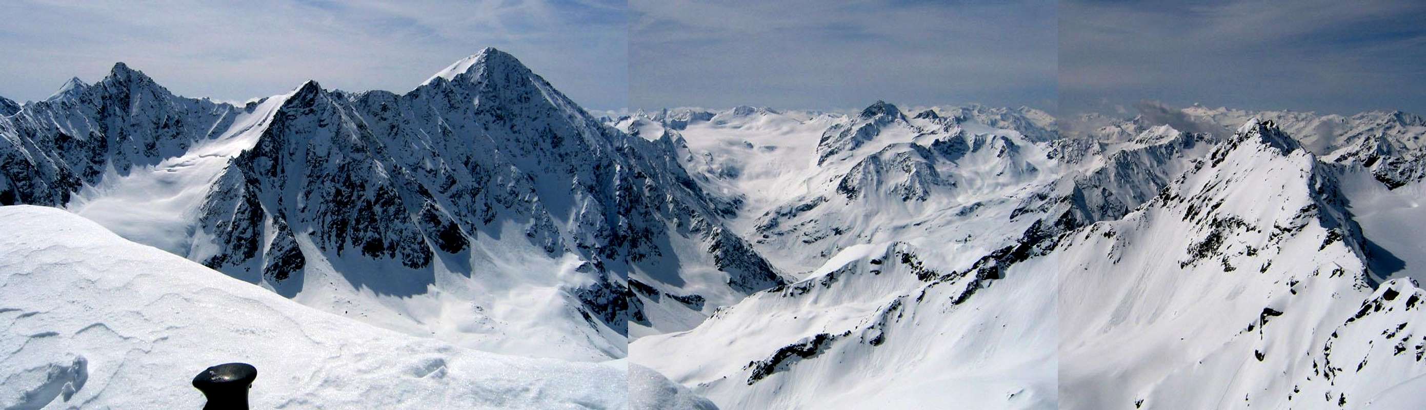
This peak is at the head of the Längentaler valley and glacier. It is gentle to ascend from the northeast along the glacier, but very steep in other directions. A climb of the Längentaler Weisser Kogel could be combined with the Bachfallenkopf (3176 m), though in winter steep avalanche prone slopes on that summit might keep you away.The summit overlooks the large Bachfallenferner (glacier) and guards the Längentaler Joch (2991 m), a high pass that grants access to the Sultztal valley to the south.
It is a popular mountain for a relatively easy ski tour in winter and spring, with the option to stay overnight at the Westfalenhaus.
From the south, the Amberger Hütte could provide accomodation for an adventure up to the Längentaler Joch, and then over and down to the north, coming out at Lisens.
  |
Getting There
From the north:By car: Innsbruck - motorway A 12 - exit Sellrain - Gries in Sellrain - Lisens parking lot.
In winter, hike the road south from Lisens, enjoying the view of the massive Lisenser Fernerkogel and it's glacier ahead. Turn west, climbing up from the flat valley floor to enter the Längental. You'll see the Westfalenhaus ahead. Continue for a long ways along the Längental valley floor, making for the glacier at it's head. Around 3000 meters elevation, the glacier turns westward. Follow it to the summit, which can be ascended on skis to the very top.
 Looking down on the glacier from the summit.
From the south:
By car: Innsbruck - motorway A 12 - exit Ötztal - Längenfeld - Gries/Sulztal - car park (free of charge) - track to the Amberger Huette (on foot/on skis)
Hike from Gries in Sulztal south and east. When valley walls close in look for a junction on the left taking you up into the Schrankar. Alternately, continue another 1/2 kilometer to the Amberger Hütte for a rest. From the junction continue up the Schrankar on to the Längentaler Joch, then turn sharply west to follow the upper Längentaler Ferner (glacier) to the summit.
Red Tape
If parking your car at Lüsens, you need 3 euros in coins (50 cent, 1 or 2 Euro coins only).Camping / Accomodation
Camping is discouraged, but here are the nearby huts:| Westfalenhaus | at 2308 meters, it takes about 2 hours to reach from Lisens. |
| Amberger Hütte | at 2135 meters. This hut is good if coming from the Sulztal valley |
Weather conditions
* Weather from the Austrian Alpenverein.Maps
* # KOMPASS #83 - "Stubaier Alpen" - A good overview (1:50,000) map. Certainly good enough for summer hiking on marked trails.* 31/2 Stubaier Alpen, Sellrain - a detailed 1:25,000 map. It doesn't show the summit as the page cuts off right before, but it is essential for the approach from Lisens.
* 31/1 Stubaier Alpen, Hochstubai - Here is the companion 1:25,000 map, showing the summit and the approach from the south.