
-
 9895 Hits
-
 86.85% Score
-
 23 Votes
|
|
Mountain/Rock |
|---|---|
|
|
49.13787°N / 7.77557°E |
|
|
Hiking, Trad Climbing, Sport Climbing, Bouldering |
|
|
Spring, Summer, Fall, Winter |
|
|
1043 ft / 318 m |
|
|
Overview
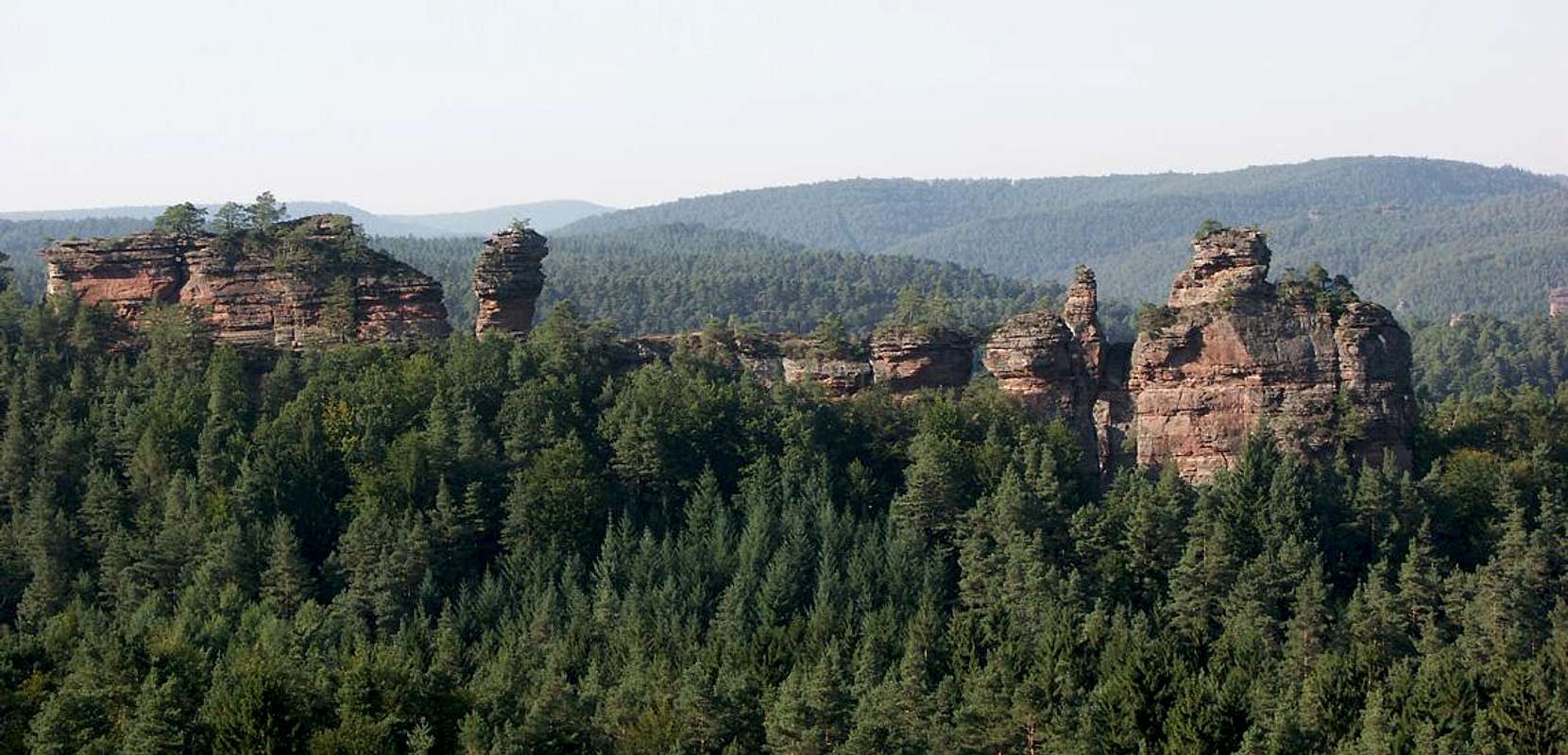
Surrounded by a large number of sandstone cliffs the town of Dahn in Germany’s Wasgau area is known as the climbing centre of its region. Dahner Felsenland it is called, the Dahn Rock Country, and wherever you look - you are surrounded by cliffs. Lämmerfelsen, located to the south-west of the town is one especially remarkable specimen, a long ridge in which one beautiful tower follows the next. While visible from the southern access road to Dahn and from the tops of the surrounding cliffs it is all but invisible from the town centre or from the hiking trails around it. Most of the ridge is hidden under the canopy of the dense beech, pine and oak forest that surrounds it.
Moreover, Lämmerfelsen is only one of three ridges which are located very close to each other there in the south-west of the town. All three share the general direction (west to east) and the fact that much of them is hidden beneath the tree tops but in other respects they are quite different.
 Büttelfels Büttelfels |
The northernmost one, Büttelfels is arguably the most popular of the cliffs, thanks to its close location to the public pool and the abundance of parking spaces around it. It consists of two rocks which are separated by a narrow crack through which one person can step apiece. There are numerous climbing routes on the crags and the most obvious feature is a rock window in the middle of the eastern rock. A hiking trail climbs the slopes directly underneath the north faces and ends right to the west of the western crag where it opens onto a vast overgrown plateau with lesser sandstone formations strewn about. Pictures of this cliff are scarce, since only the highest top of the eastern crag peeps out of the trees which stand too close to give a decent view.
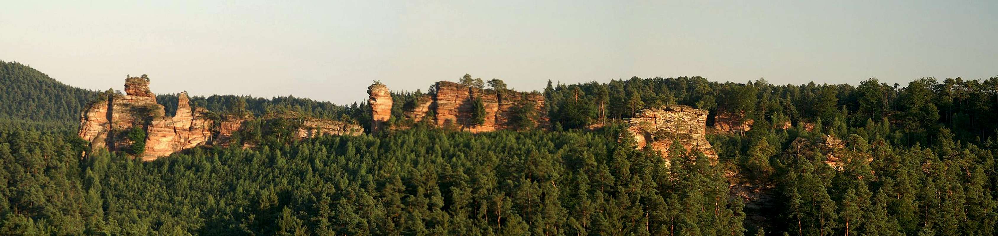  |
Lämmerfelsen itself is the largest of the three ridges. As said above and as can be seen from the panorama below (which shows only the western part) it consists of a series of alternating wide rocks and narrow spires. Like many of the Wasgau cliffs it can be reached quite easily from the mountain side (west) where a plateau suddenly starts to drop steeply to reveal the cliffs. Similar to Büttelfels the first towers are small but soon as the slope drops away the next ones get more and more impressive. The biggest and highest one, Himmelsleiter (= stairway to the sky) can be easily passed on either side on very narrow ledges at the end of which the beautiful sight of Theoturm reveals itself. The following cliffs are lower but - since the slope has dropped away all the way – the faces themselves are even higher. Hirtsfels, Bockturm and Lämmchen they are called to complete the whole sheep family (Lämmchen = little lamb, Hirt = shepard, Bock = buck).
 Durstigfelsen
The third ridge, Durstigfelsen, again consists of two crags, Ludwigshafener Turm and Landauer Turm. Both are hidden almost completely in the forest but both offer a great variety of routes. The western tower, Ludwigshafener Turm can be directly reached by a forest road, which is, however, off-limits to private cars. At the time of my visit in June 2006 both towers and the surrounding area were closed to protect breeding peregrine falcons.
All three cliffs are very popular among climbers, mostly because of the large number of routes of all difficulties. However, they are far less crowded than the Hochstein Massif on the other side of the Wieslauter Valley. This is due mostly to the fact that the access trails (except for Büttelfels) are longer and that it is not very easy to find the crags among the trees. It took me three attempts to find them :-(
Climbing Routes to the three cliffs
All three cliffs offer a great variety of climbing routes, virtually of all difficulties. The following information is linked from the web site of the Vereinigung Pfälzer Kletterer who list hundreds of (copyrighted) routes for the climbing crags of the region. Here is the link to the complete database.
| Feature | Routes link | Summary | Thumb |
| Büttelfels, Hauptgipfel | Büttelfels, Hauptgipfel | 37 routes with many variations rated 1 - 9 |  |
| Büttelfels, Westfgratfels | Büttelfels Westgratfels | 4 routes with variations rated 1 - 6 |  |
| Lämmerfelsen, Lämmchen | Lämmerfelsen, Lämmchen | 3 routes rated 1 – 5+ | |
| Lämmerfelsen, Bockturm | Lämmerfelsen, Bockturm | 19 routes with variations rated 2 – 9- | |
| Lämmerfelsen, Hirtsfels | Lämmerfelsen, Hirtsfels | 17 routes with variations rated 1 - 9 | |
| Lämmerfelsen, Theoturm Ostgrat | Lämmerfelsen, Theoturm Ostgrat | 8 routes rated 1 - 4 | |
| Lämmerfelsen, Theoturm | Lämmerfelsen, Theoturm | 9 routes with variations rated 3 – 9- |  |
| Lämmerfelsen, Himmelsleitersockel | Lämmerfelsen, Himmelsleitersockel | 4 routes rated 5- - 9 | |
| Lämmerfelsen, Himmelsleiter | Lämmerfelsen, Himmelsleiter | 13 routes rated 1 – 8- |  |
| Lämmerfelsen, Westgratfelsen Ostgipfel | Lämmerfelsen, Westgratfelsen Ostgipfel | 3 routes rated 2 – 3 |  |
| Lämmerfelsen, Westgratfelsen Westgipfel | Lämmerfelsen, Westgratfelsen Westgipfel | 2 routes rated 1 and 4- |  |
| Durstigfels, Ludwigshafener Turm | Durstigfels, Ludwigshafener Turm | 11 routes rated 5 – 7+ |  |
| Durstigfels, Landauer Turm | Durstigfels, Landauer Turm | 20 routes rated 1 - 8 |
Getting There
Lämmerfels and the two neighbouring ridges are located deep inside the forest to the south-west of the town of Dahn. The closest parking can be found close to the public pool in the west of town. Dahn itself is hidden very deep inside Pfälzerwald and thus the itineraries are a bit longish. The closest airports are at Frankfurt and Stuttgart so the itineraries start there too.From Frankfurt
There are two possible routes which both take equally long- Via Ludwigshafen
- From Frankfurt take motorway A5 southward to Darmstadt.
- There change to A67 south.
- At Viernheimer Dreieck turn onto A6 west. Leav
- e it at Frankenthaler Kreuz for A61 south.
- At Mutterstädter Kreuz take A65 south until you reach Landau.
- At Landau turn on B10 west.
- At Hinterweidental turn onto B427 south which will take you through Dahn. At the southern end of the town there is a roundabout. Take the third exit which leaves for the parking lot at the spa hotel.
- Via Kaiserslautern
- From Frankfurt take motorway A3 west
- At Mönchhofdreieck turn onto A67 south
- At Rüsselsheimer Dreieck take A60 west
- At Kreuz Mainz Süd take A63 south
- At Kreuz Kaiserslautern turn onto A6 west
- At Kreuz Landstuhl turn onto A62 south
- At Pirmasens turn onto B10 east
- At Hinterweidental take B427 south to Dahn
From Stuttgart
- Take motorway A8 to Karlsruhe
- At Karlsruher Dreieck turn north onto A5
- Tke the next exit to head for A65
- At Kandel you can leave onto B427 which will lead you directly to Dahn. However the detour to Landau and B10 will take less time as the roads are better (three or four lanes)
Red Tape

Yes, there is red tape and lots of it. The sandstone of Südpfalz forms lots of caves and overhangs. Though this makes it most interesting for climbers, two species of birds of prey compete for this habitat: the peregrine falcons and the eagle owls. Both are endangered and wherever there is a eagle owl pair found nesting in the sandstone the crag will immediately be closed. Generally this closure lasts from the beginning of each year through Aug. 1st. If breeding is not successful the closures will be cancelled even before that date. For a list of closures see the Closure List of PK. As of 2006 buth the Büttelfels summit and the whole of Durstigfelsen were closed due to Pereggrines.
The use of magnesia is not allowed in the whole Südpfalz region. This is rather a directive or an arrangement than an outright law. Thus you probably will get away with using it but do so only when absolutely necessary. Magnesia closes the pores which you find in the sandstone and together they form a smooth surface which will get very slippery in wet conditions. The rule of thumb is to use magnesia in the highest difficulty sections and only extremely sparingly.
A list of guidelines can be found here (in German).
Parking: The parking lots near the public pool of Dahn are free. However, they are not public and you shouldn't stay after nightfall.
Accommodation
In the town of Dahn you can find numerous hotels or apartments. Have a look at the tourist information site for more info. There are two campgrounds, one at Neudahner Weiher one in nearby Bruchweiler-BärenbachWeather Conditions
The closest available weather information is the one for Pirmasens (20km to the north-west):Pirmasens weather
Maps & Books
Maps
As for maps there is a good overview map (1:50000) by Kompass Verlag but the best ones are the official topographic maps by the state government of Rheinland Pfalz, scaled 1:50000, 1:25000 and 1:5000. All official maps can be found on the web page of Landesvermessungsamt Rheinland Pfalz
1:50000
- Naturpark Pfälzer Wald
Kompass Map WK766
ISBN: 3-85491-523-3
- Bad Bergzabern
LVA RLP Map L6912
ISBN: 3-89637-194-0
1:25000
Books
There are a number of climbing guidebooks on the region of Südpfalz. The best ones, however, have been published privately and are sold only in selected bookshops of the region.
- Hiking
- Pfälzerwald
B. & J.-Th. Titz
Rother Verlag
ISBN: 3-7633-4268-0 - Klettern im Buntsandstein
U. Daigger, H.-J. Cron
Published privately and out of print
- Pfalz ++, Klettern im Buntsandstein
R. Burkard, P. Weinrich
Published privately
- Klettern im Naturpark Pfälzerwald
Naturfreunde Lambrecht
Published privately - Pfalz & Nordvogesen en bloc
A. Wenner, Y. Corby, I. Bald
Panico Verlag
ISBN: 3-936740-19-4
Climbing