
|
|
Mountain/Rock |
|---|---|
|
|
36.08810°N / 51.95200°E |
|
|
Mountaineering |
|
|
Summer |
|
|
14035 ft / 4278 m |
|
|
Overview
Click for Introduction to Central Alborz Mountains.Click for Detailed Map of Central Alborz Mountains
Click for a detailed map of Shekar Leghas area peaks.
Name Alert: Many maps/mountain climbers in Iran call this peak “Nazer” (pronounced Naa-zer). In this discussion Nazer refers to the 3888 m peak to the north of Shekar Leghas. One could call Shekar Leghas, “Nazer the Great” and the 3888 m peak, “Nazer the Small”.
  -->Right=West=Azad Kooh 4390 m (lone peak) |
 Shekar Leghas from Kaoon
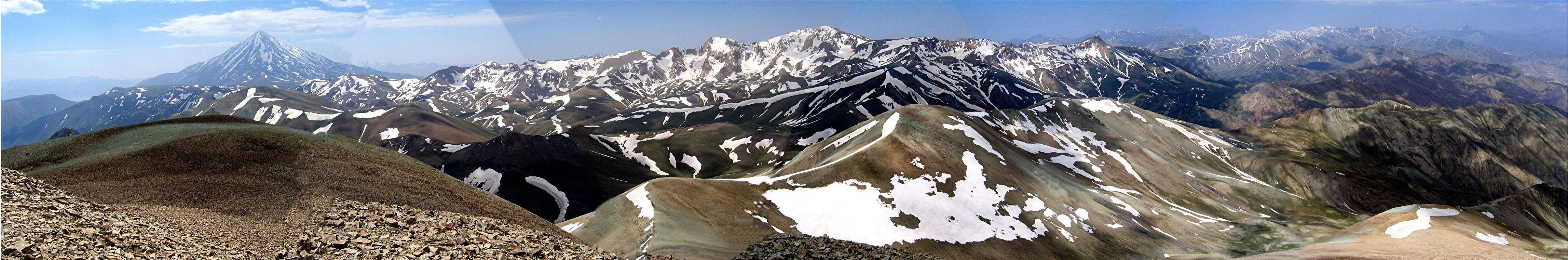
Unlike the jagged summits of Dokhaharan and its neighbors to the south, Shekar Leghas and its nearby peaks are nothing more than huge piles of crushed rock. The rock on the higher slopes has a gray/teal hue while the lower slopes are of a shade of pink. This gives the mountains a very distinctive appearance.
When we visited the area in mid June, only a few patches of snow remained on Shekar Leghas. This is in contrast to the vast snow fields that still covered much of the northern slopes of the Dokhaharan Peaks and their neighbors to the south. The summit of Shekar Leghas provides an ideal spot for viewing these peaks as well as the giant cone of the nearby Mt. Damavand.
Shekar Leghas is most directly climbed via the Paniri River Valley to the east of it, which leads to the village of Nomar (2150 m). I have not done this route but will instead offer two more indirect routes. The first one goes to the Lehra saddle and Sesang Valley allowing the hiker to camp there and climb some of the nearby peaks before moving on to Shekar Leghas. The second one will take the hiker past a lower peak known as Varzan Khortab (3629 m) to the village of Hatar to the northwestwest of Shekar Leghas. Due to a very long and steep slope, I recommend the second option as only a descend route.
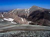
 The southern slopes of Shekar Leghas
Getting There
 The northwestern slopes from Hatar Village
For Nomar Village:
From eastern Tehran, drive the Haraz Road (Tehran-Amol) past the towns of Baijan and Kahrood until you see a sign that says “Amol 55 Km”. A few Kimlometers beyond this sign you will find a dirt road on the left (west) side of the road. This road is well-graded and is passable by most/any car. It might be inconspicuously signed for “Panjab” or “Nomar”. Drive the road 25 km to its end at the village of Nomar (also known as Nomarestagh). Distance from eastern Tehran is roughly 130 Km.
For Hatar Village:
From eastern Tehran, drive the Haraz (Tehran-Amol) Rd roughly 120 Km to a place called Hardorood (at the junction of the Haraz & Noor River Valleys). Turn west and drive the Yoosh-Baladeh Rd about 50 Km to reach the town of Baladeh. Continue west another 3-4 Km till you see a road on the left (south) side crossing the Noor River. Turn onto this road and drive it one Km to the village of Kolyak.
At Kolyak, right goes to Betaher Kala Village and left to Hatar. When we were there in 2006, the road beyond Kolyak was not paved but was smooth and passable by any vehicle. Drive the dirt road 15 Km to the end of it in Hatar.