
-
 8243 Hits
-
 84.27% Score
-
 18 Votes
|
|
Mountain/Rock |
|---|---|
|
|
38.00597°N / 13.21230°E |
|
|
Hiking, Scrambling |
|
|
Spring, Summer, Fall |
|
|
3822 ft / 1165 m |
|
|
Overview
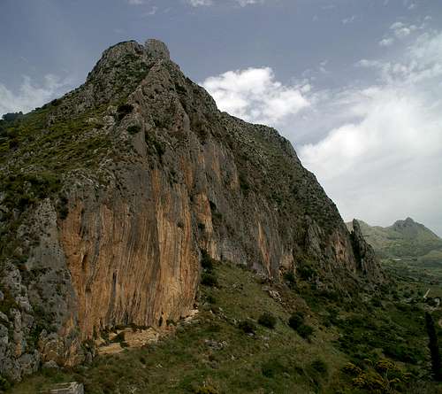 Pizzo Mirabella south face Pizzo Mirabella south face |
Pizzo Mirabella is yet another of the impressive rocks of the western Sicilian highlands. Like Rocca Busambra or Monte San Calògero it is located quite close to Sicily’s capital, Palermo. In effect Pizzo Mirabella is part of the scenic mountains which surround the picturesque Iato Valley – and to be honest – it is the most scenic one. But before concentrating on the mountain at hand, let’s first have a glimpse at the Iato Valley itself. It is shaped like a horseshoe, open to the north-west. It is the only place in Sicily in which hiking trails have been established and in true Sicilian fashion they are announced even from the motorway around Palermo. However the trails have fallen into disrepair in many places, so don’t be sure to find signs or even paths where they are supposed to be. To the south of the horseshoe you find Monte Iato and La Kumeta, to the east La Pizzauta and to the north Pizzo Mirabella, Pizzo Aiello and Monte della Fierra. All of the mentioned mountains show impressive rock faces (few of them climbable due to the brittleness of the limestone) and none more so than Pizzo Mirabella.
The Mirabella south-west face is a tall 500m vertical affair, very impressive from all sides - but the most impressive from the south-west itself. About 50m from the top the wall recedes, only to reveal another vertical wall (though much smaller) – the summit block. Like so often you can negotiate the mountain fairly easily from the opposite side – but don’t be fooled – the summit block is still to be accounted for. Even if the north-west side of the summit block offers a grass slope – getting on top requires real determination.
Not to mention path-finding abilities! The mountain is climbed rarely and though there are climbing paths most are overgrown, most signs have fallen or vanished altogether and in effect the macchia poses an even greater stumbling block (quite literally) than the summit itself. The “easiest” (if you can call it so) path to the summit follows a gully or chimney, which is overgrown with macchia. And in case you don’t know what macchia means – here you’ll find out: nettles, rock roses, thistles, gorse and blackberry brambles, in short, anything that stings or scratches. You will reconsider climbing the top as your access route will have consisted of the same: nettles, rock roses … - you get the message…
Is the climb worthwhile? Yes and no. It is worthwhile as you are above that huge vertical drop to the south-west base of Pizzo Mirabella. Also the close up (Cresta di Mirabella) and medium views (Iato Valley) are rewarding. However, there is not so much as a faraway view, certainly not if the Sicilian haze doesn’t lift above its usual level. In the rare case that it does you’ll find yourself seated neatly above the western Sicilian highlands, a rural and agricultural area with lots of nice hills, rocks and mountains interspersed.
|


The Mountains of the Iato Valley
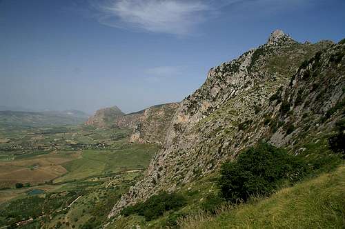 Pizzo Mirabella above the Iato Valley
As already stated in the overview section, the Iato Valley is horseshoe shaped with its open end at the western side. Pizzo Mirabella is the highest summit of the northern branch of this horseshoe with Monte della Fierra (971m) and Pizzo Aiello (930m) further to the west and Cozzo di Fratantoni (1065m)to the east. The eastern part of the horseshoe is dominated by La Pizzauta (1333m) and Portella la Ginestra, a saddle which separates it from the Kumeta ridge (1233m) in the south. This latter already belongs to the southern branch of the horseshoe which ends with Monte Iato (852m) right above San Giuseppe.
|


Getting There
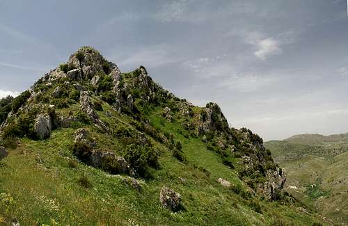 Pizzo Mirabella summit "block"
Sicily can be reached from all Italian and the major European airports by plane. There are two large airports, one at Catania in the east and one at Palermo. Since Palermo is much closer to the mountain than Catania my itinerary starts here. Also, Palermo is the main ferry port in the area.
From Palermo airport
- Take motorway A29 direction Palermo
- In Palermo the motorway turns into a four laned city highway which circles the city to its south
- While on the city highway turn onto SS624 direction Altofonte and San Giuseppe Iato
- At the exit San Giuseppe Iato turn off onto SP20 east (away from San Giuseppe) and in a sharp turn turn left opnto a potholed road to Masseria la Chiusa
Red Tape
 Aporia crataegi
There is no red tape in the Iato Valley. However, much of the valley is used agriculturally so keep on the trails. As mentioned above these trails have fallen into disrepair so nobody will blame you if you lose them. Close any gates you come across and in case you have to cross a field go to its edges and don't stroll across directly.
Accommodation
You can quite easily find hotel rooms and apartments everywhere on the coasts and naturally in Palermo itself. All European travel companies offer accommodation so a visit to your nearest travel office will find you some. In the mountains themselves accommodation is much harder to come by. Since camping is not allowed (see red tape) you have to ask at the local inns. Moreover there are some farms which offer “agriturismo” though on Sicily this often means only food and no rooms. Masseria la Chiusa is one of these establishments.Weather Conditions
Sicily is located very close to northern Africa (Marsala on the west coast is closer to Tunis than to any place on the Italian mainland), thus temperatures can get very high. March, April and early May are the best months if you plan to hike the mountains, the winter can be wet, the summer scorchingly hot. Here the nearest weatherunderground link for Palermo:Maps & Books
Maps
Unfortunately there are no current topographic maps of Sicily. The best are reported to be more than 50 years old and probably are the same as the basis for the digital maps of atlanteitaliano.it.
As a workaround you can use street maps for general orientation together with a good guidebook (see below). The most accurate maps are scaled 1:200000, sometimes detailing everything down to forest and dirt roads through the mountains. I settled for
- Sizilien
Shell Generalkarte
1:200000
Mairs Geographischer Verlag
ISBN: 3-8297-2080-7
Books
Since there are no good topographical maps of Sicily you should take care to get a good guidebook. The one I used is in general excellent. For Pizzo Mirabella the route descriptions in the book are excellent, however the trails and paths are hard to be found. Instead of following the directive to climb the summit block "left of the ridge" it is better to climb a steep meadow spm 50m to the right and then climb the summit via the north ridge. The book is available in German and English.
- Sizilien / Sicily
M. Omidvar
Rother Verlag
ISBN:
3-7633-4266-4 (German)
3-7633-4813-1 (English)