
|
|
Canyon |
|---|---|
|
|
37.44500°N / 110.041°W |
|
|
Hiking, Scrambling |
|
|
Spring, Fall |
|
|
Overview
Bullet Canyon is the largest tributary of Grand Gulch. Since it’s a large canyon system in itself, it deserves its own page.Like Grand Gulch, Bullet Canyon is an “outdoor museum” and one of the best places in the world to hike for an archeological interest in a scenic and wilderness setting, rather than under a glass case in a museum in some large city. Bullet Canyon is full of Anasazi Indian ruins, as well as several earlier archeological sites. Most ruins are around 800 to 1200 years old, but some are as recent as 700 years old, and some are as old as 2000 years old.
Around 1300 AD the Anasazi moved south and into the Rio Grande Valley of New Mexico. Since then, so one has ever lived in Grand Gulch, but the ruins of an ancient civilization remain.
The rediscovery of the Grand Gulch system, including Bullet Canyon happened in 1880, and several archeological parties visited the canyons between the years 1890 and 1897. Now days, it is very illegal to remove or otherwise disturb the sites in any way. Please leave the potsherds, corn cobs, and ruins for other future generations to enjoy.
Bullet Canyon itself is almost eight miles long, and hikes range from one day to several weeks if you are using this canyon to access others in the Grand Gulch system. There are many opportunities and variations possible.
Bullet Canyon actually varies from Grand Gulch in many ways. One, vegetation and water is more plentiful. The canyon is also chocked with boulders in the upper end, and drops much more steeply than Grand Gulch. There are also some sections where the canyon bottom is smooth slickrock, rather than the wide sandy bottom that is the norm in Grand Gulch.
Some of the ruins in Bullet Canyon also are different from any found in Grand Gulch. In particular, there are two rim top “lookout tower” ruins at the head of Bullet Canyon. Perhaps they were there to look for invaders or strangers. Unlike Grand Gulch, you can’t sneak into the canyon, but would be visible from the towers.
 The Perfect Kiva ruin in Bullet Canyon.
Getting There
This area can be reached from the east from Blanding and along Highway 95, from the west and Hite along Highway 95, or from the south via Highway 261 and Mexican Hat, or Highway 47 north from Bluff. Make sure to have a good roadmap before heading into this area. The closest town with gas is Blanding, about 40 miles away from the upper trailheads.The Kane Gulch Ranger Station is located four miles south of the Highway 95/Highway 261 junction and is right near mile marker 29, and just about everyone stops here for information. It is also necessary to stop here for overnight permits for the high season.
From the Kane Gulch Ranger Station, drive south along Highway 261 to just south of mile marker 22. Turn west (right) and drive to the trailhead which is reached after 1.1 miles.
Routes Overview and Suggested Routes
Hiking through Bullet Canyon is more rugged than hiking through Grand Gulch. The route is slower, and there is some class-3 scrambling involved. There are some slickrock ledges and some boulderhopping in the upper canyon. The lower section of the canyon consists of mostly easy trail walking.There are many ruins and archeological sites to be seen in Bullet Canyon. There are some sections with water as well, and some nice campsites. The route through Bullet Canyon is around 7.5 miles long. See the route page for more details.
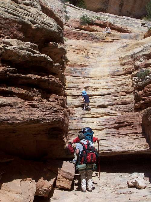 Scrambling in Bullet Canyon.
Here are some suggested routes. There are actually many possibilities.
One Day:
Hike the upper end of Bullet Canyon, viewing the Lookout Tower Ruin, and exploring the slickrock areas and return.
Two Days:
Hike Bullet Canyon to Grand Gulch and return, visiting Jailhouse and Perfect Kiva Ruins along the way. This will be a 15 miles round trip.
Hike Sheiks Canyon, Grand Gulch, and exit Bullet Canyon. Since I haven't done Sheiks Canyon, see either Canyon Hiking Guide to the Colorado Plateau, 5th edition or contact the rangers at Kane Gulch Ranger Station for more information.
Three Days:
Hike down Kane Gulch, down Grand Gulch, and exit Bullet Canyon.
Hike down Bullet Canyon, Grand Gulch, and exit the Government Trail.
Four Days:
Hike down Bullet Canyon, down Grand Gulch, and exit Collins Spring.
Seven to Nine Days:
Hike Bullet Canyon and Grand Gulch to the San Juan River, up the San Juan River, and finally exiting via Slickhorn Canyon. Depending on the route, this is about a 63 mile hike. Slickhorn is close enough to Bullet that you can do the car shuttle with a bike, or by a long walk.
Mileage Chart
| LOCATION | MILEAGE | EXIT (TRAILHEAD TO TRAILHEAD DISTANCE) |
| Bullet Canyon Trailhead | 0 | |
| Perfect Kiva Ruin | 4.5 | |
| Jailhouse Ruin | 4.8 | |
| Jailhouse Spring | 5.0 | |
| Grand Gulch/Bullet Junction Spring | 7.2 | |
| Descend Bullet Canyon and exit Grand Gulch/Kane Gulch | 22.8 | |
| Descend Bullet Canyon and exit Government Trail | 21.4 | |
| Descend Bullet Canyon and exit Collins Spring | 29.5 |
Red Tape
Permits are now required for hiking and camping in Bullet Canyon. See the official website below for more information:Cedar Mesa BLM Website
HIGH SEASON – March 1 – June 15 and September 1 – October 31
Day Use Permits
$2.00/per person/per day
$5.00/per person/ 7 consecutive day pass
Permits may be obtained at each trailhead through a self pay system.
Overnight Permits
$8.00/per person/per trip
All advanced and walk in overnight permits must be picked up on the day of your trip at the Kane Gulch Ranger Station between 8:00 a.m. and 12:00 noon, 7 days a week. Advanced overnight permits may be reserved up to 2 days prior to your trip through the Monticello Field Office at (435) 587-1510.
Commercial groups, groups of 8 or more people, or groups using pack or saddle stock must obtain their permits by advance reservation through the Monticello Field Office. Walk in permits will not be issued to these groups.
OFF SEASON – June 16 – August 31 and November 1 – February 28
Day Use Permits
$2.00/per person/per day
$5.00/per person/ 7 consecutive day pass
Overnight Permits
$5.00/per person/per trip
All overnight and day use permits may be self issued at each trailhead during the off season.
Overnight permits for commercial groups, or groups using pack or saddle stock must be obtained in advance through the Monticello Field Office at (435) 587-1510.
ANNUAL DAY USE PASSES
The annual day use pass is $20.00 and can be purchased at the Monticello Field Office or the Kane Gulch Ranger Station. This pass is good through the calendar year and will cover all passengers in the vehicle.
ARCHEOLOGICAL SITES
Disturbing or removing any archeological sites is strictly illegal. Please leave artifacts for others to enjoy.
 An ancient potsherd we found in Bullet Canyon. It is probably 1000 year old. It was upside down and looked like a stone until we picked it up. We put it back exactly where we found it.
Seasons
Spring:March through May is the best time to hike Bullet Canyon. Water is usually more plentiful than in other seasons, and days are long and pleasant. March and April can be cold and April and May can be hot, but most of the time, this is the prime to go.
 Hiking Bullet Canyon on a rainy and cool May day.
 Summer:
Summer (June through August) is cooler in the upper canyon, and very hot in the lower sections. Expect hot days and little water. Hiking and camping is still possible, but not as pleasant.
Fall:
Fall (September through November) is another good time to hike Bullet Canyon, but the first half of September is usually really hot, and late November can be cold and snowy. Temperatures are similar to Spring, but there isn’t as much daylight. Fall colors usually peak around mid to late October in Grand Gulch.
Winter:
Winter (December through February) can be pleasant if you are prepared, but the upper canyon can be cold, snowy, and icy, the route can be dangerous. If there isn't snow or ice present, winter is a good time to go, but the route into Bullet is difficult under icy conditions.
Weather Forecast and Conditions
Bad weather usually isn't a problem here, and the canyon is wide enough that rain usually poses little danger (this is not true of some other canyons in the area).CLICK HERE FOR AREA WEATHER FORECAST
Weather and climate data for the Natural Bridges National Monument, elevation 6500 feet, and located near the Bullet Canyon Trailhead, is below. *National Weather Service Data 1965-2006. This should be representative of the upper end of Bullet Canyon.
| MONTH | AVE HIGH | AVE LOW | REC HIGH | REC LOW | AVE PRECIP (in) |
| JAN | 40 | 19 | 60 | -11 | 1.01 |
| FEB | 45 | 23 | 68 | -13 | .83 |
| MAR | 52 | 28 | 77 | 6 | 1.16 |
| APR | 61 | 34 | 85 | 6 | .83 |
| MAY | 73 | 43 | 93 | 22 | .72 |
| JUN | 84 | 52 | 101 | 30 | .46 |
| JUL | 89 | 59 | 103 | 41 | 1.33 |
| AUG | 86 | 57 | 99 | 40 | 1.56 |
| SEP | 77 | 50 | 95 | 22 | 1.33 |
| OCT | 65 | 39 | 86 | 6 | 1.38 |
| NOV | 50 | 28 | 78 | -2 | 1.01 |
| DEC | 41 | 20 | 61 | -14 | .91 |
Weather and climate data for the Mexican Hat, elevation 4250 feet, is below. *National Weather Service Data 1948-2006. This should be representative of the lower end of Bullet Canyon.
| MONTH | AVE HIGH | AVE LOW | REC HIGH | REC LOW | AVE PRECIP (in) |
| JAN | 45 | 20 | 69 | -17 | .59 |
| FEB | 53 | 25 | 78 | -8 | .51 |
| MAR | 62 | 31 | 86 | 7 | .52 |
| APR | 71 | 39 | 93 | 11 | .46 |
| MAY | 82 | 49 | 104 | 27 | .47 |
| JUN | 93 | 58 | 109 | 38 | .24 |
| JUL | 98 | 66 | 110 | 50 | .57 |
| AUG | 95 | 64 | 107 | 46 | .62 |
| SEP | 87 | 54 | 103 | 29 | .71 |
| OCT | 74 | 41 | 94 | 19 | .92 |
| NOV | 58 | 29 | 82 | 8 | .59 |
| DEC | 46 | 21 | 68 | -16 | .51 |