
|
|
Mountain/Rock |
|---|---|
|
|
44.42410°N / 9.10050°E |
|
|
Hiking |
|
|
Spring, Summer, Fall, Winter |
|
|
3199 ft / 975 m |
|
|
Overview
ENGLISHCroce Dei Fò is a mountain of Ligurian Apennine out of main line of high summits.
It’s place between high route of Ligurian mount ( AV = Alta Via, High Route ) and the sea, at only 6 km away Bogliasco village ( Genova ) place on the sea-shore.
The north and west side of mountain ae a light roundish slopes, covered on the first part by trees and on the higher part is bare and grassy.
The south and east side are more steep complete covered by trees than other sides.
ITALIANO
Croce Dei Fò è una montagna dell’appennino ligure al di fuori della linea principale delle vette più alte. E’ situata infatti a metà strada tra l’alta via dei monti liguri e il mare a soli 6 km dal paese di Bogliasco ( Genova ) situato in riva al mare.
Il lato nord e ovest della montagna è un dolce declivio tondeggiante ed è ricoperto per metà da alberi mentre la parte superiore è spoglia ed erbosa.
Il lato sud ed est sono più ripidi interamente coperti da alberi.
 East side
Getting There
ENGLISHTo reach by car the starting point of Croce Dei Fò, exit at Genova Est toolgate ( motorway A 12 Genova – Rosignano ( Livorno )) and follow the road signs to Molassana and in second time always to Piacenza, along the Bisagno river.
After, ignoring the signals to Traso and Chiavari ( both on the right ), always on the main road, we arrive at Bargagli. Here we find the road sign to S.Alberto on the right. We must run the road until going up. Before going down, we arrive at maximum point were there’s a park, where is possible to leave a car. The path is visible in front of us.
ITALIANO
Per arrivare tramite automobile uscire al casello autostradale Genova Est ( A 12 Genova – Rosignano (Livorno)) e seguire le indicazioni per Molassana e in seguito sempre per Piacenza seguendo il corso del torrente Bisagno.
Dopo aver ignorato le indicazioni per Traso e per Chiavari entrambe sulla destra, sempre sulla strada principale giungiamo al paese di Bargagli. Da qui cerchiamo l’indicazione per S.Alberto sulla destra. La strada la dobbiamo percorrere tutta finchè sale. Giungiamo così al punto massimo prima di scendere sull’altro versante. Qui fermandoci, notiamo un parcheggio dove lasciare l’auto. Il sentiero è ben visibile davanti a noi.
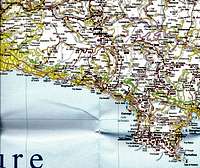 Great map of Croce Dei Fò
Itinerary
ENGLISHNorth West ridge ( Yellow line on the image below ). S.Alberto ( 678 mt ) Croce Dei Fò ( 975 mt ). Difference in height 297 mt
Signal path : 1 red triangle.
The path is simple, never exacting. In the first part, in plane, we walk along the edge of mountain;
The path is horizontal, inside the wood. We meet some ruins of old country home. Now the path is very aerial and we follow it until a gate not to allow the walk. We notice that our mountain now show the west side. Not exist a clear path but is impossible to lose himself.
We climb the side quite light covered only by grass.
We arrive at a first hump, where is possible to see for the first time the top, before hidden. We maintain always the same direction, we can walk up, toward the minor top ( in front of us at left ).
A light saddle separe us by the summit with the cross on top.
ITALIANO
Cresta Nord Ovest ( linea gialla nell'immagine sotto ). S.Alberto ( 678 mt ) Croce Dei Fò ( 975 mt ). Dislivello 297 mt
Segnale del sentiero : 1 triangolo rosso.
Il sentiero è facile, mai impegnativo. In un primo tratto essenzialmente pianeggiante si costeggia orizzontalmente la montagna all’interno del bosco. Si incontrano alcuni resti di vecchie case di campagna. Il sentiero ora si fa più arioso e lo si segue fino a che un cancello ci impedisce di proseguire. Notiamo che la nostra montagna l’abbiamo aggirata di 90 gradi circa e quello che si espone a noi è il versante ovest. Non esiste più un sentiero definito ma perdersi è impossibile.
Si rimontano così i declivi abbastanza leggeri coperti solo da erba. Giungiamo ad una prima spalla da dove è possibile vedere per la prima volta la vetta vera e propria, prima nascosta dalla sua anticima nord. Manteniamo essenzialmente sempre la stessa direzione che avevamo intrapreso da quando avevamo lasciato il sentiero e puntiamo sempre in salita verso l’anticima nord ( davanti a noi leggermente a sinistra ). Un leggero colletto ci separa dalla vetta con la croce posta in cima.
 Visual itinerary
Top
ENGLISHFrom the top ( 975 mt ) we can see the sea so near because in direction of the sea, the mountains are lower than Croce Dei Fò.
It’s visible the west part of Portofino promontory ( Chiappa Cape ) and a great part of east coast of Liguria.
The east side of minor top ( toward nord of Croce Dei Fò ) has a deep precipice covered by trees.
On top there’s a white cross 2 meters high.
ITALIANO
Dalla sua vetta ( 975 mt ) è infatti possibile ammirare il mare incredibilmente vicino perché tra la sua cima e il mare le montagne degradano sempre di più.
E’ visibile la parte ovest del massiccio promontorio di Portofino ( Punta Chiappa ) e gran parte della riviera di levante.
Il versante est dell’anticima nord si getta in un profondo precipizio coperto da alberi.
In vetta c’è una croce bianca alta 2 metri circa.
 |  |
Meteo
Information Meteosat Airport of Genova Sestri : C.ColomboEPSON METEO
GENOVA 12 km far-away
WEBCAM GENOVA LEVANTE