Day One
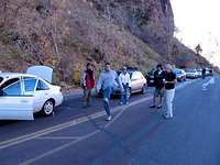
We decide to park and sleep at a place to the side of the road to save some money for the first night. We got there at 3 am so we fall out of the car and fall right asleep. After four hours of sleep we get up to go into the park and meet up with the rest of the group. We got a descent start. We probably hit the road at around 8:30 am. So we start the drive along zion mount carmel hwy. We get to the tunnel and the ranger says it will be a half hour wait! It's a good thing we have a hacky sack.
So on this day we did Birch Hollow. And this isn't meant to be a detailed description of how to get to the canyon but I'll put what I know.
Out of the first larger tunnel we went about 8 miles down the road and turned left onto North Fork Road. We went for another 8 miles approx. We parked at 37°18'35.20"N and 112°51'23.20"W and then we dropped down into the wash. Temperature was good, not too hot but warm enough to work up a little sweat to the first rappel.
We could have skipped the first rappel but all were for rapping it. Even Su! This was going to be her very first rappel. We were all impressed that she was starting with this 120 ft free rappel to begin with. We trusted a natural anchor that looked good and was already around a large tree. We had a 230' static rope and it was about 6 feet from the ground doubled up. So we tied into the anchor to went down on a single line. The next rappel also had a natural anchor and wasn't much further down. Some icicles had formed which made for some good pictures.
If I remember right, from here on out bolts with webbing and rings were placed at each rappel. One of the best rappels came about 3/4 down the canyon. The rappel goes down a sort of chimney that is smooth and straight.
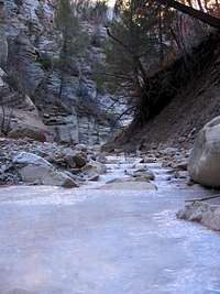
After two or three more rappels we were out of the canyon and started the hike back up by following the frozen stream upstream. It was really neat to see how the stream had frozen in layers.
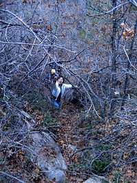
Then we got a scare when we noticed water flowing down suddenly. Luckily the flow remained low so it must have been from ice or snow melting because as far as we knew this wasn't a controlled release canyon for irrigation like Kolob. We abandon the stream for a wash and start hiking uphill. This turn off could be really hard to see unless you have been there. From this point on we got out the GPS and headed in the general direction of the car trying to stay on trails when we found them but it was mostly bushwacking. A machete would come in hand for this part.
We eventually got to a ridge where we found some fourwheeler tracks and were able to follow those back to the road. We dropped into the canyon around 10:30 am and got back to the car at about 5 pm so 6 and a half hours is longer than we were expecting. We went back to camp as the sun was setting at about 5:30 pm. Then we just kinda chilled and ate and talked.
Day Two
We decided to do a fun short one, Yankee Doodle. We didn't feel rushed so we didn't leave camp until about 10:30 am. To get to Yankee Doodle. Backtracking to Toquerville then heading south we got off on the first (and only?) exit in Leads. Passing through and out of the town we got onto a dirt road that was passable in our passenger cars. The riskiest it ever got was a couple of streams and a rocky section. We parked at 37°14'15.00"N and 113°27'9.00"W then hiked south and a little west to the first rappel into the canyon around 37°14'11.02"N and 113°27'11.00"W. The guide we had said we could make the big rappel at the beginning either 100ft or 170 ft. We didn't find a spot to make it 170 ft but it was probably close 140 ft. We found tree and set up a natural anchor. We used a 60 meter rope and rappelled on a single line. We picked a decent spot to rappel from as most of it was a free rappel and the pictures with the scenery turned out good.
![yankee doodle 1]()
We left the rope as it had been tied into the anchor. Then proceeded down the canyon then rest of the shorter drops could be and were down climbed by some while others of the group used a smaller rope with just our own body leverage as an anchor.
There were only two spots where there was water. The first could not be avoided as the sides were muddy and too slippery to bridge across. This little pool got up to almost the neck and it was plenty cold in the shaded canyon. The next was a little bit of a keeper hole but after the first two made it through they were able to help the rest bypass it altogether. We got out of the canyon by smearing up the slanted rock on left side. We then came across a wash and followed it to the road.
Comments
No comments posted yet.