
-
 3380 Hits
-
 73.06% Score
-
 3 Votes
|
|
Route |
|---|---|
|
|
46.36203°N / 14.66976°E |
|
|
Hiking |
|
|
Summer, Fall |
|
|
Half a day |
|
|
Medium hard walk-up |
|
|
Overview
Veliki vrh can be ascended by various routes. Here, a round tour will be described. This ascent is by no means the shortest one. It combines also the summits of the NE ridge. But it is certainly the most beautiful one, as panoramic views from the NE ridge are unsurpassable.
As to the best time for this tour - it is desired that the ridge is mainly snow-free. In winter conditions the tour is harder, but also possible and very beautiful. Snow conditions also partly determine the descent route. In summer perhaps the direct descent to Sedelce (as described here) is less atractive and you might choose the usual, SW descent on the marked path. This route description can be interesting also because on Veliki vrh page the route from Sedelce to the summit is not described yet. You start the tour on the Ravne alpine meadow, 1500 m. How to get there, see the main page of Križevnik,
Rating the Tour (by Hiking Standards)
|
The grading system for hiking and scrambling routes is here. 0. General. From 1500 m to 2114 m, some ups and downs on the NE ridge. Mostly by unmarked paths, on the upper part of the NE ridge only a weak trail or traces. Descent to Sedelce is marked. The rest of the descent is also a good, marked path. Gear: Only good shoes and poles. Milestones of the route: Planina Ravne, 1500 m - Planina Polšak, 1700 m - Križevnik, 1910 m - Poljske Device, 2028 m - Velika zelenica and Veliki vrh, 2114 m - Sedelce, 1835 m - Planina Ravne. Overall grading by the SAC Hiking Scale would be T4. 1. Effort. Cca 900 m of altitude, 5 h 30 min, some 4 hours for the ascent on Veliki vrh. 2. Power. 1 - only walk-up. 3. Psyche. 3 - medium, one a bit more steep, exposed place. 4. Orientation. 3 - medium. |
Route Description
Before Planina Polsak
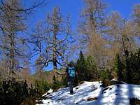
On the upper, northern part of Ravne meadow, find the marked path which goes towards the Korošica hut. Here, this path still has the northern direction. In some 10 minutes you pass the forested summit of Smrekovec (on the right), on the ridge, which connects it to Dleskovec you still go by the marked path, which on the other side descends a bit and starts turning left (towards the NW). Follow it by a shallow valley, until you reach a hardly noticable crossroads. The marked path goes left, straight (you deter a bit right from the marked path) goes a non-marked path to Polšakova planina (meadow). On the rock there's a weak arrow and an inscription 'Lučka koča' (in a memory on a small hut, which was here close-by and was burned during the World War II). You follow the path a bit up and down over the plateau, the direction is in the first minutes NE, then N. After reaching the lowest point (1600 m) you start ascending towards Brinova peč, 1673 m, but before it the path turns left (towards the NW) and soon you reach the nice, open meadow, Polšakova planina, 1700 m. This meadow can be reached by non-marked paths also from the South-East and North-East.
Krizevnik from the SW
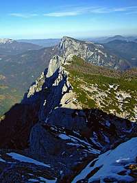
From the meadow you go either towards the North or towards the North-West by non-marked paths. Also the northern path soon starts turning left and soon joins the other one. Now you follow the path towards the North and just below the main ridge reach the crossroads. On the summit of Križevnik you go right, towards the NE. Soon you hit the main ridge, taste some of the panorama, but the path again avoids dense dwarf-pines over the southern slopes. Soon you are on the fore-summit where the panorama is already stunning. But go also those few meters on to the main summit, from which you'll be able to enjoy also the panorama towards the East (Raduha etc.).
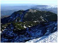
The view from Krizevnik
From the summit of Križevnik we return to the crossroads below the main ridge and continue by a quite good tracable path along the ridge towards the SW. We don't step on the main ridge until we pass the lower summit of Poljske Device, 1879 m. As it is covered with dense dwarf-pines, we probably won't ascend it. Reaching the base of the higher summit of Poljske Device, trails (or a weak path) turn us a bit towards the left. So we cross the slopes, the path is easy. We constantly ascend a bit and also cross towards the left, so finally we are some 100 meters away from the main ridge. There we turn up again more decisively, gain some altitude and after some more crossing we reach just below the summit of the higher Poljska Devica, 2028 m. (On older maps this summit was also referred to as Molička peč, which is strange, as the alpine meadow with this name is on the other side of the mountain.) From the path it is worth ascending the summit in a few minutes.
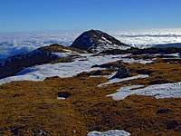
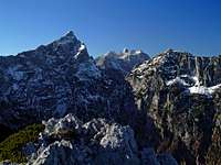
Veliki vrh
From the upper Poljska Devica we cross its slopes to the base of Velika zelenica summit. From here on, we are ascending more or less in the vicinity of the main ridge or just left of it. The ascent is nice and panoramic. Where we approach the final rocky step, we must go just on the main ridge, climb a few meters of easy rocks (still a bit exposed walk-up or a very short, easy climb of UIAA I), and on the top we are. The broad, grassy plateau of Velika zelenica extends towards Veliki vrh, which we reach in the next few minutes of panoramic hike. By a big ciarn of Veliki vrh we decide upon the descent.
The descent route
If we decide for the direct descent route to Sedelce, we go from the summit of Veliki vrh a few minutes back by the ridge to Velika Zelenica and there find the marked path right down. The upper descent is again quite steep, then the path starts crossing the E slopes of Veliki vrh towards the SE. The world is very rugged and overgrown by dwarf pines, but the path is new and the whole descent quite easy. We all the time see Sedelce, 1835 m, the broad saddle below Dleskovec, where we hit the marked path, coming from the Korošica hut. From Sedelce we continue our round tour by the marked path over the northern slopes of Dleskovec on Ravne meadow, which lies just on the other side of this mountain.