

-
 24082 Hits
-
 77.34% Score
-
 9 Votes
|
|
Mountain/Rock |
|---|---|
|
|
34.20098°N / 118.26932°W |
|
|
Los Angeles |
|
|
Hiking |
|
|
Spring, Summer, Fall, Winter |
|
|
3126 ft / 953 m |
|
|
Overview
Verdugo Peak is the highest bump in the Verdugo Mountains and serves as Burbank and Glendale’s crown. Covered with chaparral and scrub but skirted with sycamore and oak lined canyons, the area is a recreation destination neglected by most Angelinos. At 3126 feet the peak rivals nearby Echo Mountain and other San Gabriel Front Range peaks in stature and has a similar makeup, but is cut off from the larger range by the 210 freeway and the Crescenta Valley. The peak provides those who make the effort with one of the better vantage points to take in a sunset in LA County and offers a jaw-dropping night-time perspective on the humanity that has filled in the LA Basin. There are a network of trails that snake through this hills and the ridge is bisected by a fire road.The Verdugo Mountains can be circumnavigated by car in an hour or less. They are surrounded on all fronts by urban development, but a good chunk of the mountains are still wild. Because the Verdugo Mountains are surrounded on almost all sides by freeways, except the North West, it is a simple matter to access the various places where one can venture into the mountains. Note, however, that there are portions of the Verdugos that are simply inaccessible to humans, and also remember that the soil is crumbly, so very steep canyon sides need to be avoided.
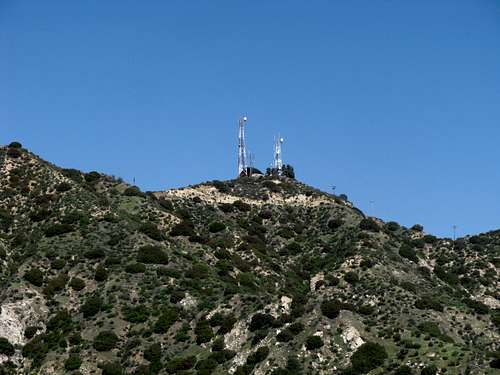
The summit of Verdugo Mountain is occupied by a communications tower accessed by fire roads. A fence surrounds the communications tower and there is a really neat vantage point with a makeshift bench that you can sit on and lean back against the fence surrounding the communications facility. Here is a view of the summit taken from Wildwood Canyon:
The summit views are incredible and you really can sit there and look out at LA. You can see downtown LA, look down on the Hollywood Hills, span the Valley, check out the LA basin all the way down to Palos Verdes and Catalina Island on a clear day, look East and see Pasadena, view down on Burbank Airport, and this is just the South view. If you look North, you can see Mount Lukens, Strawberry Peak, San Gabriel Mountain, Mount Wilson and more. Did I also mention that you can see Century City, Santa Monica, the South Bay, and more? (Check out views on the Verdugo Mountain Brand Park Canyon hike that are similar to the views from this summit.) This makes this summit extremely enjoyable, every time you are there and spend the time to enjoy the view. Also, because access to the summit is not difficult, this is a perfect place to take family members or those not very experienced in mountain hiking.
There is a network of fire roads that run through the Verdugo mountains, with the most easily accessible roads being on the North side. Once the network of fire roads is accessed, from whatever feeder trail, and there are many, you can hike up to the summit if you so choose. Note, however, that there are many viewpoints and hikes that probably do not end at the summit. Once you have been to the summit, it is often preferable to simply enjoy the trails without making the extra effort to walk on fire roads to the summit.
If one is a peakbagger looking for a quick summit, it can be obtained here. But there is so much more to enjoy if one spends the time to explore this unique mountain island. There are several vistas to be had from other areas in the Verdugo Mountains easily accessible by a variety of urban access points and a number of hikes, well known to local residents, capitalize on such access. Because a network of fire roads and trails criss-cross the Verdugos, which allows hikes from various access points to be connected, one can piece together hikes of various lengths, from several hours to an all day adventure, although a shuttle may be required when the exit point is not part of a loop.
The access to the summit of Verdugo Mountain is easiest from the North. The elevation gain is less from the North, and fire roads are accessible from the North. Indeed, cross country runners from Crescenta Valley High School periodically run up one of these roads to the summit. Also, access from the North can be had from hikes with tree cover, something not found on the South. However, access from the South has advantages. It offers more of a challenge, and good trails for exercise, along with some adventure possibility if one is willing to proceed uphill off trail. But South trails are in the sun, and there is no water, so they can be very hot on hot days.
Suggestions for reaching the Summit
Although the summit of Verdugo Peak can be reached by many different ways once the network of interconnected fireroads in the Verdugos is accessed, if you want something that is a little more interesting, here are three suggestions.One approach, which is the most challenging, is to take the Verdugo Mountains Brand Park Canyon Hike to the point that it gains a fireroad, and then proceed to the summit. There is a detailed Route description of this approach up to the fire road. This route involves off trail hiking, up steep slopes, and is not for the faint of heart. It goes up ridge lines, with no switchbacks. The fireroad path from this approach to the summit is visible in the following photograph:
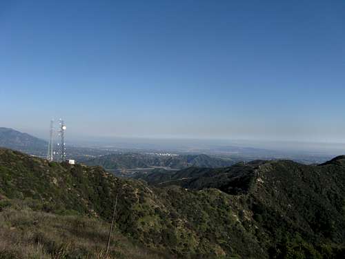
This view is shot from the summit of Verdugo Mountain looking East. If you start at the communications gear at the left of the picture, you can follow a fire road heading East.
Another approach is part of what is described by Jerry Schad as "one of the more adventurous trips in [his] book." This route is detailed in Jerry Schad's book (and maybe will be detailed in a future route on this page); it begins in Burbank and moves up an old (and unmaintained) dirt road and then ends up on the fire road network. From there, one proceeds to the summit, although this is not the route that Jerry Schad describes. It is not as strenuous and wild as the Verdugo Mountains Brand Park Canyon Hike to gain the fire road network.
A third approach is to take one or both of the access points from La Tuna Canyon described by Jerry Schad in his route "North End Traverse." An advantage of such an approach is that it comes from the North whereas the first two approaches are from the South. Also, such an approach involves some shaded trees and much different fauna than one finds in the sun-scorched South facing routes.
Red Tape
No Red Tape to speak of. Park is open from dawn till dusk. An Adventure Pass is not required for parking in any of the areas where you might want to start a hike. Parking is usually readily available at or near any of the access points that you might want to start at.Wildlife
Deer roam the Verdugo Mountains, and they can be seen on occasion. Unfortunately, one or more mountain lions have also been spotted roaming the Verdugo Mountains, and this includes sightings in 2012. The Verdugo Mountains are also home to coyotes, rattlesnakes, ticks and other wildlife. Hawks and other wild birds can be seen roaming and hunting in the mountains. So one needs to remember that just because you can always see urban civilization, you are not in an urban park.Equipment
If you are hiking on a known trail or fire road, no real equipment is needed. If you are exploring your own route up a hill side, you may want hiking poles, and you probably want a hat, long sleeves and pants to avoid ticks.If you are hiking the Verdugo Mountains when it is hot, especially from a South facing exposure, realize that there is no water availability in the mountains, and one should bring plenty of water. Because of close proximity to urban development, some hikers have found themselves caught without water, and a few rescues stemming are discussed in the news link noted in the external link heading. This should not be a problem for anybody who is prepared.
A camera is nice to carry. You never know when you may see something special, and the views are always nice.
Camping
Primarily a day-use area. No camping.External Links
For directions and other information on additional trails in the Verdugos, visit:Verdugo Mountain General Info
LA Mountains.com - La Tuna Canyon Trail
LA Trails - Verdugo Mountains
To obtain information and local news about the Verdugos, visit:
http://articles.glendalenewspress.com/keyword/verdugo-mountains
Try Google Maps, satellite view, for hikes you may want to go on. Because the Verdugo Mountains are surrounded by urban civilization, you can get much more resolution for many hikes than what you may be used to, and it is also very interesting.