
-
 7346 Hits
-
 85.87% Score
-
 21 Votes
|
|
Mountain/Rock |
|---|---|
|
|
28.29864°N / 16.83337°W |
|
|
Hiking |
|
|
Spring, Summer, Fall, Winter |
|
|
3409 ft / 1039 m |
|
|
Overview
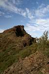
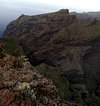
 Los Pajares seen from Montaña de las Rosas Los Pajares seen from Montaña de las Rosas |
The Teno mountain range in the north-west of Tenerife is one of the oldest parts of the island. Toether with the mountains on the Anaga Peninsula in the north-east and the area around Roque del Conde in the south it formed one of three island during the creation of the island. Later, about 1-2 million years ago the volcanic hot spots moved to the center, creating the bulk of the island and with it Teide and the Cañadas del Teide. In these older parts of the island volcanic activity stopped while erosion set in. Today only the hardest pyroclastic rocks as well as some basalt layers are left standing, giving the areas a very wild and rough appearance while their height is restricted to not much more than 1000m. The Teno range - as the highest one of the three, is famous for its barrancos, profound gorges which are separated by high and exposed ridges. The ultimate gorge is Barranco de Masca, a narrow winding canyon which is bounded by 1000m high ridges. The southern of these ridges can be rather easily reached from the road connecting the villages of Santiago del Teide and Masca and its eastern part (i.e. the part close to the road) is among the more popular hikes in the Teno Range.
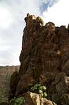
The ridge separates Barranco de Masca from Barranco Seco, an equally profound canyon. Part of the ridge is razor sharp and therefore very exposed. It is composed of basalic rocks, which results in a skyline of summits, called Los Pajares. The highest of them is 1039m high and offers an absolutely stunning view into the two canyons. Part of the path leads through the vertical north face of this summit, breathtaking, though it is rather broad and protected. This highpoint of Los Pajares is located about 3km from the trailhead at the road and can be reached by an exposed old shepard's trail, Camino de Guergues.
Behind the Los Pajares highpoint the ridge gets broader, somewhat resembling a plateau, Lomo de Tablada. It was used for keeping goats and even for small patches of fields, for which several ruined huts bear witness. Though the path leading to these huts vanishes behind the last of them it is advisable to bushwhack your towards the west coast. The risge narrows again with breathtaking views into Barranco Seco and finally ends 500m from the coast. 500m that is in each direction, vertical as well as horizontal. In this place it offers great views of the cliffs near Los Gigantes as well as of the neighbouring island of La Gomera.
|


Views
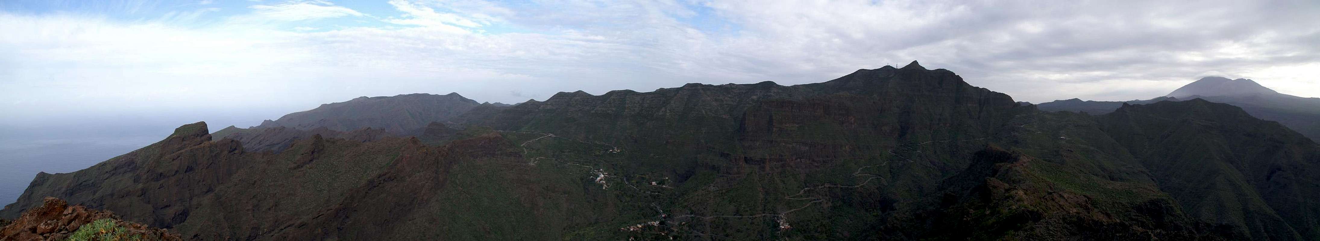  |
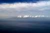
It was not the perfect day to climb along the Los Pajares ridge. Teide was hidden beneath a lenticular cloudcap and the rest of the island slowly hid beneath a cloud cover. Moreover sand from Sahara winds produced a thick haze. Still the deep looks into the gorges were breathtaking and even La Gomera was visible 60km away.
|


Getting There
 |
The village of Masca is one of the most popular spots on the island of Tenerife. Millions of visitors go there each year though only a small fraction of them actually hike into Barranco de Masca or climb one of the ridges in the vicinity. Most simply drive along the mountain road which connects Santiago del Teide with Buenavista del Norte. If you come here for climbing avoid this road as much as possible. It is very narrow and the tourons drive so very slowly that you won't reach your trailhead in time. Especially as the road is infested with coaches as well. Keeping that in mind the fastest approaches to the trailhead are as follows.
From the North
Avoid going to Buenavista del Norte. Rather take the motorway TF5 to Puerto de la Cruz and Los Realejos and follow the coastal road (still TF5) to Icod de los Vinos. There turn south onto TF82 and follow the road through El Tanque and Erjos to Santiago del Teide. It is a winding narrow mountain road and it takes quite a while to get to Santiago. There turn north-west onto TF436, direction Masca. Drive over the saddle Degollada de Cherfe and park your car a couple of turns below at a mirador overlooking Masca and the vertical walls closing in on it.
From the South
Take motoway TF1 to its end at Adeje. There either follow TF82 through Guia de Isora to Santiago del Teide or follow the coastal road TF47 to Los Gigantes and TF454 to Santiago. The latter route takes much longer but offers great coastal views. From Santiago take TF436, direction Masca and follow the instructions above.
Red Tape
There is no actual red tape in the Teno mountain range. However, the land is used for farming and belongs to the locals of the area. They have agreed to hiking trails being created which traverse their fields but request that hikers stay on them. Also, any gates should be left the way you found them. The ridge of Los Pajares has only one gate right at the beginning and is only used for extensive goat grazing.Near the trailhead at TF436 there is a small farmhouse. The path to Los Pajares does not lead through its yard. There are lots of signs by the farmer requiring privacy. Problem is, that the start of the path is not evident so that you might end up at the farm. Rather keep to the right here.
Accommodation
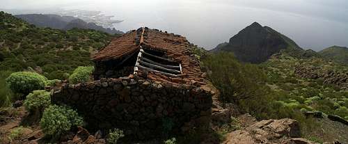 Finca de Guergues and the coast at Los Gigantes
Of course you can find a lot of hotels, fincas and casas on the island which you can book from any travel office. The closest tourist location is at Los Gigantes and Puerto de Santiago. The Teno mountain range can be easily reached from the towns in the north as well as the ones in the south and simply requires a 1h - 2h drive. In the villages of the range you can find inns where you can find a place to eat and maybe even to sleep. You should not count on the latter, however. Camping is not allowed in the Teno Range.
Weather Conditions
There are several sites on the web which give you information on the weather on Tenerife. The following table shows data for Puerto de la Cruz on the coast.| Month | Jan | Feb | Mar | Apr | May | Jun | Jul | Aug | Sep | Oct | Nov | Dec |
| Avg. day temp.[°C / °F] | 19 / 66 | 19 / 66 | 20 / 68 | 21 / 70 | 22 / 72 | 23 / 73 | 24 / 75 | 26 / 79 | 26 / 79 | 24 / 75 | 22 / 72 | 20 / 68 |
| Avg. night temp.[°C / °F] | 13 / 55 | 13 / 55 | 14 / 57 | 14 / 57 | 16 / 61 | 18 / 64 | 19 / 66 | 20 / 68 | 20 / 68 | 18 / 64 | 17 / 63 | 14 / 57 |
| Water temp.[°C / °F] | 19 / 66 | 19 / 66 | 19 / 66 | 19 / 66 | 20 / 68 | 20 / 68 | 22 / 72 | 23 / 73 | 22 / 72 | 22 / 72 | 21 / 70 | 20 / 68 |
| Rainy days | 10 | 7 | 8 | 4 | 3 | 2 | 1 | 1 | 3 | 5 | 7 | 9 |
The Canarian Islands (as well as Madeira) are located in the trade wind zone. You almost always encounter northeastern winds which carry a lot of humid air. Being forced to climb to higher altitudes this moisture condenses into clouds. This in return means that most of the time the northeastern part of the islands is covered in clouds from altitudes of 1000m through 2000m. The Teno and Anaga Ranges often are covered in clouds, though mostly along the north coast. Los Pajares is already several km to the south and offers significantly better weather. Still the skies often are overcast.
Maps & Books
Out of the multitude of maps and books I have been using the following. However, so far I have not found a good hiking map of the island. The one posted here is ok but shows only a fraction of the marked hiking trails. The guidebook is excellent but be careful if you do any one of the suggested "variations" to the tours described therein. The variations are described in a few words only and you might get the wrong impression of their quality.- Maps
- Teneriffa
Kompass Map WK233
Kompass Verlag
ISBN: 3-85491-038-X
Books
- Teneriffa, Tenerife
K.Wolfsperger, C. Ade
Rother Walking Guide
Rother Verlag
English - ISBN: 3-7633-4809-3
German - ISBN: 3-7633-4016-5