
-
 30032 Hits
-
 93.1% Score
-
 41 Votes
|
|
Mountain/Rock |
|---|---|
|
|
34.21660°N / 117.6893°W |
|
|
Los Angeles |
|
|
Hiking |
|
|
Spring, Summer, Fall, Winter |
|
|
5796 ft / 1767 m |
|
|
Overview
This peak, apparently named for being a nice locale to enjoy the setting sun, also provides a sweeping vista of the wonderful horseshoe-shaped ridge that encircles the upper end of San Antonio Canyon. Furthermore, you can get to the summit relatively quickly by ascending the peak’s 1.5 mile north ridge.
A fire lookout tower once stood on this peak, but only uninteresting remnants remain. The views are what you come for. From the top of Sunset, Mt. Baldy (10,064’) dominates the view to the northeast. To the southwest of Baldy stands Sunset’s nearest higher peak, Lookout Mountain #2 (6,812’) a little less than 2.5 miles away as the crow flies.
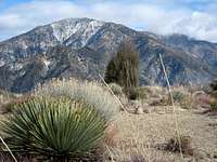
Mt. Baldy in back and Lookout Mtn.#2 (center left) from summit of Sunset Peak
Moving your gaze clock-wise to the east, you will spot Thunder Mountain, Sugarloaf Peak, Telegraph Mountain and then Ontario Peak.

Ontario Pk. (8637') from summit of Sunset Pk.
L-R, Thunder Mtn., Sugarloaf Peak (6924') and Telegraph Pk. from Sunset Peak's north ridge
To the northwest, the line of peaks above Crystal Lake is quite impressive.
Route One
The shortest but harder of the two routes listed here is the 1.5 mile north ridge from Cow Canyon Saddle. The ridge is Class 1. The 3 mile roundtrip has 1,300 feet of gain. The route is a straight shot to the top along a fire break. At two places along this ridge route, you will meet and cross the fire road.

View northwest from north ridge
Route Two
This is a fire road route, 7 miles roundtrip with 1,300 feet of gain. This route begins from the junction of Forest Road 2N07 with the Glendora Ridge Road, 3.2 miles past Cow Canyon Saddle where the first route begins. Go past the fire road gate and follow 2N07 for about 2 miles where you pass a junction with the road going back down to Cow Saddle. Continue ahead on 2N07 to a second junction at the ridgetop saddle (5,560’) just south of the peak. Take a sharp left here on a spur road and follow it to the summit.
Getting There
From the 210 Freeway, exit at Baseline Road in the City of Claremont. At the bottom of the off-ramp, turn left (west) on Baseline Road and go to Padua Ave., the very next traffic light. Turn right on Padua and go north 1.8 miles to Mt. Baldy Road. Go right on Mt. Baldy Road and continue for about 8 miles to Glendora Ridge Road in Mt. Baldy Village.
Turn left onto Glendora Ridge Road and in one mile you will be at Cow Canyon Saddle.

Cow Canyon Saddle
The large dirt area on the north side of Glendora Ridge Road used to have a large sign on it with the name of the saddle (see photo taken in January 2007), but the sign is no longer there. There is parking along the south side of Glendora Ridge Road and some park in the large dirt area.

Sugarloaf Peak from Cow Canyon Saddle
As you face south, the ridge route from Cow Canyon Saddle begins about 75 yards to the left of a battered yellow gate on the south side of Glendora Ridge Road. You will see the obvious fire break where you begin climbing.
Note that the yellow gate mentioned above is the beginning of a fire road (2N07) that also goes to the summit. However, this route crosses private property and so it is not listed here as one of the options.
For an easier, but longer route, continue past Cow Canyon Saddle 3.2 more miles to the junction with Forest Road 2N07. There is a small parking area on the left here. Go past the gate there to begin your route on this fire road.
Red Tape
No permits are required for hiking. However, you will need an Adventure Pass to park your car. You can purchase one ($5 per day or $30 for a yearly pass) at the Mt. Baldy Visitor Center on Mt. Baldy Road just a little past Glendora Ridge Road going north. Or you can buy a pass at most Southern California sporting goods stores.
Camping
Manker Flat is the closest campground in the area. It is, however, several miles away from the Cow Canyon Saddle trailhead.
When to Climb
Year round, except that you may encounter snow and/or icy conditions during the winter months. Accordingly, come prepared with appropriate gear for the conditions.
Mountain Conditions
Check the Mt. Baldy website for Mt. Baldy area weather conditions.
Other Information
USGS ToposMt. Baldy 7.5
External Links
Mt. Baldy website
Angeles National Forest
DM88T - Nov 5, 2016 11:44 pm - Voted 10/10
some historySunset Lookout
Augie Medina - Feb 4, 2017 1:31 pm - Hasn't voted
Re: some historyThanks for this.