
-
 3731 Hits
-
 72.08% Score
-
 2 Votes
|
|
Route |
|---|---|
|
|
43.00120°N / 2.02456°W |
|
|
Mountaineering |
|
|
Spring, Summer, Fall |
|
|
A long day |
|
|
Class 3 |
|
|
I |
|
|
Overview
 Malloas
Of all the itinerarys possibles in Aralar the most important and beautifull route is the full traverse of all the peaks of the ridge of Las Malloas. It's a very long traverse of 7-8h with 1600 meters of slope and it's neccesary the use of 2 cars to return to the trailhead.
Generally the traverse it's realized from SE to NW and the most popular itnerary it's from Baraibar to Gaintza (or Azkarate).
Notes: it's a long itinerary and a good training is very important. If you don't know your forces the exits of the ridge to descent to Gaintza are located in:
-Elekomutz, col between Irumugarrieta and Aldaon.
-Uako lepoa, between Beoin and Uakorri.
-Astunal, col between Uakorri and Artubi.
Note about the time required: I have not realized the full traverse nowadays (I'll try this year) but I climbed many of the peaks of the ridge in different days but when it walked all the peaks in the same day the effort accumulated enlarges the time required and by that reason some information of this point it's taken from the description of Iñaki Alcalde in the guide Aralar of Miguel Angulo.
Getting There
For approach to Aralar take direction to Pamplona, the most important city neary to Aralar. From Pamplona take the highway A-15 to Alsasua, take direction Donosti/San Sebastian to the village of Lekumberri (inverse if you come from Donosti or Vitoria to Lekumberri before Pamplona).From Lekumberri we take the road of Santuario de San Miguel in Excelsis just in the entry of the village near of the crossroad to camping Aralar. After a few of km we reach the village of Baraibar (635m).
Alternative: we can to follow the track to the antenna in the hill of Dolboa (905m) to park the car and to reduce the long itinerary.
Route Part #1
 Alborta
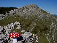 Ttutturre
The fist part of the route it's the ascent to Irumugarrieta, the highest point of the ridge (and of the Sierra de Aralar).
 Pallardi
 Neguri
We'll walk the track in direction to the antenna, after some meters we turn to the track of front and in the second we get a path to leave the track (to not walk a long curve) to reach the hill of Dolboa (905) with a lot of antennas. After a little descent we'll reach the hut (borda) of Izarrite (880m). The track with stones goes in the forest between the hills of Gaztelu (1080m) and Txurtxur (1055m). We'll leave the forest of beeches in a fence and the last paths of the route. From this point the route is out of path and the references are the peaks and the cols.
We'll go to west in direction to the huts of the plain of Etzantza and we'll climb the hillside of the peak Arriolatz (1176m, 2h) and descending to a col we'll attack the peak Uarrain (1224m, 2h 15min). The landscape is very good and we'll see the cone of Ttutturre in NW. We'll descent to another col and we'll climb the ramp of Alborta (1228m, 2h 40 min) signalled with a mailbox.
 Kurutzeaga
 Malloas
The route is evident from here and we'll can see the access of the summit of Ttutturre on right side but we'll don't climb the rocky ridge of left side. The col under us is the entry of normal route from Albia.
Walking the zig-zag of the ramp west and climbing the last rocks (very easy, grade I) we'll reach the summit of Ttutturre (1282m, 3h).
 Beldarri
 Irumugarrieta
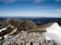
After a new descent we'll reach the col of Abateko lepoa (1150m) between Ttutturre and Pallardi. After a short walk we'll climb the summit of Pallardi (1290m, 3h 20min). The path disappear and we'll descent in direction SW to the col of Illorbi (with the little huts of Neguri, 1195m) and we'll walk across the ramp of the little Atallorbe to its summit (1275m). The ridge to Irumugarrieta is visible from here.
After a little col (1235m) we'll attack the ramp SE of the wide Mendiaundi (1310m). We'll descent to a new little col (1227m) and we'll climb the rocky Kurutzeaga (1310m), point of access to the ridge of Irumugarrieta. Across the col of Arrutako Lepoa (1225m) we'll reach the summit of Beldarri (1404m). A short walk-up among the stones of the karst brings to us to the summit of Irumugarrieta (1431m, 4h45min).
Route Part #2
 Aldaon
 Elekomuts
The hardest part of the route it's climbed but still rest a lot of walk and summits, generally with less slope. If you are very tired you can exit of the traverse in the point signaled above in overview.
Descending of the summit of Irumugarrieta near of a metallic fence we'll reach the col Elekomuts (1352m) and we'll climb little by little the path to the summit of Aldaon (1411m, 5h15min).
The descent it's important now to the col Andargorriko aldapa (1305m) walking easily over the little summit of Egurbea (1325m) before the climb of Beoin (1359m, 5h 30min).
 Beoin
Beoin Artubi
A new descent bring to the col of Uako lepoa (1188m). Across the little summit of Elizkaitz (1215m) we'll reach the summit of Uakorri (1306m, 6h or more). After a new col, Astunalde (1216), and a new summit, Artubi (1262m), we'll see finally the last summit, and one of the most beatifull, the peak Balerdi. Unfourtunelly we'll reach this ridge generally very tired and it's the most exposed pass. Some people can desist to this climb but a short ridge of grade I with the use of the hands in some exposed stepcrossings bring to us to the summit of Balerdi (1195m, 6h45 or more).
 balerdi
 Balerdi
For the return generally we'll come back to the col Astunalde to descent to the village of Gaintza after 8h. It's necessary to park another car in this village before to drive to Baraibar to begin the walk.
Alternative option to descent from Artubi is walking in NW direction to the peak Zabalegi (1060m) descending to a track to the col Larrondo (700m) the track go to the village of Azkarate in east direction (right). The same consideration about the car.
Essential Gear
Water (1 or 2 lit./person).In some days of winter crampons and ice-axe but I think it's not a good idea the climb (not enough sunny hours and with snow the effort and the time is bigger, the ridge of Balerdi it's not advisable in winter)
Diego Sahagún - Sep 14, 2011 5:32 am - Hasn't voted
Las malloas, la cresta del dragónhttp://www.diariovasco.com/20070808/gente/malloas-cresta-dragon-20070808.html
Rafa Bartolome - Sep 14, 2011 9:54 am - Hasn't voted
Re: Las malloas, la cresta del dragóninteresante link, casi todo ya está descrito en SP en la web de Aralar incluyendo parte de la leyenda de Teodosio (con foto de las cadenas y todo). El recorrido desde el Guardetxe (que por cierto fue derruido hace 1 año) también al ser el clásico para subir a irumugarrieta. A pesar de ser como el patio de nuestra casa este paisaje de las Malloas nos sigue emocionando y levantando el espíritu.