Introduction
This article will outline the story and details behind the discovery of Outlaw Arch which is located in
Dinosaur National Monument. The original discovery was made on September 3, 2006 by Adam Pastula, Michael Kelsey, Stephen Ho, and myself.
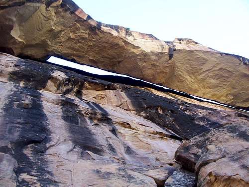
![Outlaw Arch, West End]() Outlaw Arch from below.
Outlaw Arch from below.
An excerpt from the Outlaw Peak mountain page is below:
While climbing Outlaw Peak (a name we tagged on it because the nearest named feature was Outlaw Park) and descending Outlaw Arch Canyon, (also our name) [later we found that for at least twenty years this canyon has been known to some locals (especially river rafters) as “Scoggin Draw.” The 1941 inscription mentioned near the mouth of the canyon, was made by Charles Scoggin] we discovered something special by surprise. What we discovered in the canyon and on a bench on the side of Outlaw Peak was a large natural arch. On September 30, I returned with Jeff Fox and got accurate measurements on the arch. At 206 feet, it turned out to be the 9th largest known arch in the world, and the largest "new discovery" reported in the United States since Wrather Arch (Paria River Canyon) was first reported in the 1950's. Only one arch since then has been reported to be over 200 feet and it is in Africa in 2004.
One may wonder how an arch could be hidden for so long (until 2006!), but there are three main reasons.
1. Since it stands against the cliff wall, it really isn’t visible from the air unless you know it is there. Now that we know it is there, it is visible on photos taken from the air.
2. The arch is not visible from below, and you can’t get to it from below.
3. The arch is well hidden in a remote canyon, and the route to get there is very obscure.
This article will tell the story behind the discovery and provide more information and details about why the arch wasn’t discovered earlier. This article will also explain the key events that led up to the discovery of the arch.
See also these other three links:
Natural Arch and Bridge Society
Largest Known Natural Spans
Outlaw ArchThe Location
Dinosaur National Monument is famous for both its dinosaur bones and for it’s rafting, but has been almost completely ignored by hikers and climbers (which include canyoneers).
Pull open any guidebook to Colorado with the hikes and climbs marked, and you will notice the big blank spot in Northwestern Colorado. This area of Colorado, without question, has the most remote peaks in Colorado and almost certainly even has some un-climbed peaks. The peaks are incredibly spectacular and almost completely ignored, despite the fact that it offers some of the best scenery in the lower 48 states. Over a dozen very inaccessible peaks invite exploration. Only a few of the more accessible peaks are on Summitpost, but there is enough exploring here to keep one busy for years.
There are all kinds of spectacular canyons here as well. From big and scenic to tight slot canyons, this area has enough exploring left for years. There are literally dozens of seemingly completely unexplored slot canyons in the area.
In all my years of exploration in the area, I have only run into people in Jones Hole and Harpers Corner. The rest of the area is very little known. I’ve found one cairn, no hikers, and no footprints in all my years of traveling here, even on holiday weekends. Over Labor Day weekend, there was neither a soul nor footprint to be found for miles and miles around.
In the spring and early summer, many rive runners do run the Yampa River Canyon, and these are about the only people using the area. Climbers, hikers and canyoneers have always ignored the area.
The oversight from hikers and climbers combines with the remoteness and lack of information on routes and the fact that the logistics and routes are complicated have all kept this area off the radar for many years. This was probably the main reason the arch has remained hidden so long.
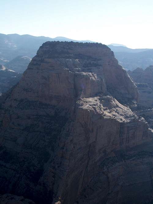
![Outlaw Peak]() Outlaw Peak towers above the surrounding canyons and is well guarded by cliffs. Finding a route to the summit was a challenge.
Outlaw Peak towers above the surrounding canyons and is well guarded by cliffs. Finding a route to the summit was a challenge.The Story of Discovery-Introduction
On September 3, 2006, our climbing and canyoneering team consisting of climbing team Adam Pastula, Michael Kelsey, Stephen Ho, and myself had just completed a successful ascent of Outlaw Peak. In addition to climbing the peak, descending (what is now known as) Outlaw Arch Canyon was the main goal and object of the day.
The story starts earlier than September 2006, however. Although I have visited Dinosaur National Monument several times previous, it was my quest for both finding remote peaks and especially for finding new slot canyons that opened up the first chapter in discovering the arch. See the article below for some background:
Colorado Slot Canyons
Putting this route up to access the Outlaw Park canyons systems and peaks is one thing I have been working on and off for the last three years. A route from the north proved too rugged and impractical. A route from Mantle Park didn’t work out. There were a few more trips that ended without finding any viable routes to access the area. Finally in April 2006, we climbed the point on the south side of the river for a good close up view of Peak 6489. We got off track and just happened to spot the couloir that would be the key to the lower part of the route. The upper part of the route was discovered mostly by accident when looking for routes into the nearby canyon. The obscure route up to “Key Saddle” proved to be the key that unlocked the door to accessing Outlaw Peak and the nearby canyons.
On our trip in early September, we had the goal of accessing the two canyons around Outlaw Park and hopefully climbing a peak. The routes are complicated and access would not be easy. We had no idea how we would access Outlaw Arch Canyon [Scoggin Draw], but had a pretty good idea about accessing Outlaw Canyon.
![Handlining]() Exploring Dinosaur National Monument in April 2006.
Exploring Dinosaur National Monument in April 2006.Part I-The Approach
After meeting on September 2, we started with full backpacks and an assortment of all kinds of technical gear and headed down Red Rocks Canyon. We hiked down river to opposite Outlaw Park, passing some nice pictographs and petroglyphs along the way. After dropping camp on the beach we set off to access “the canyon with the mysterious keeper pothole” and to explore around.
![Wading the Yampa]() Wading the Yampa River near Outlaw Park.
Wading the Yampa River near Outlaw Park.Part II-Part II-Exploration, the mysterious missing pothole, and an accidental discovery
The mysterious missing keeper pothole was a fluke, but turned out to be a key event in the discovery of Outlaw Arch. Earlier that April, from high atop a cliff we spied a short but possible interesting canyon with what appeared to be a huge keeper pothole (in which are always challenging obstacles).
Since this was the first day, and since some of it was used up in the approach, we were after just a short and challenging canyon. We found the route we had spotted from the cliff in April and accessed the drainage we thought the pothole was in. Unfortunately we didn’t remember where in the canyon the big pothole was so we searched around in vain. No pothole. Where could it be? We spied it from the cliff and it was HUGE. How could we miss it? We explored along the rim up canyon looking for clues. The canyon looked moderately interesting, but we couldn’t find the pothole and the canyon didn’t look as good as we had hoped. We also checked the next drainage to the west looking for the pothole. We dropped our packs and looked around. At the head of the “Missing Keeper Pothole Canyon” I noticed the notch southeast of Peak 6489. We had wondered if we could climb up to it. Could it be the key to accessing the two much larger canyon systems that we had so desperately been looking for a viable route into for the past few years? Adam took the honors of exploring the ledge system above the saddle to see if it went around the corner. It did and the saddle was accessible! The route wasn’t too hard, albeit was very exposed.
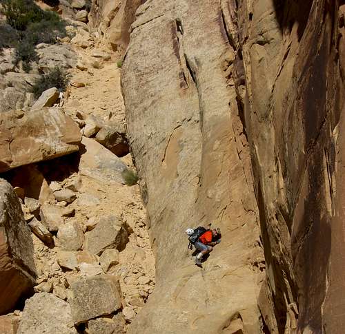
![Traverse]() Part of the exposed traverse on the Key Saddle Route up Outlaw Peak. Update: There used to be a crack below this you had to either step over or do this little climb AJ is doing, but as of November 2008 it is buried in a new rockslide and you now just walk over it.
Part of the exposed traverse on the Key Saddle Route up Outlaw Peak. Update: There used to be a crack below this you had to either step over or do this little climb AJ is doing, but as of November 2008 it is buried in a new rockslide and you now just walk over it.
We all went to the saddle (now known as the “Key Saddle”) and went back to retrieve the packs. I also found a lower ledge system that led to the saddle on the way back.
After retrieving the packs, we could access the saddle and Outlaw Canyon. We also noticed that we might be able to climb Outlaw Peak and access (what is know known as) Outlaw Arch Canyon. This saddle was the key we had been searching for! The fluke of searching for the missing pothole had lead to an accidental discovery.
(It wasn’t until a trip four weeks later that I found the location of the pothole. It does exist, but it’s closer to the river than we were looking and is right above a spring and grotto).
![Key Saddle]() The Key Saddle
The Key SaddlePart III-Outlaw Canyon
This will be described only briefly since we are now off the route that leads to Outlaw Arch, but is mentioned as a side note. We descended
Outlaw Canyon via a rugged chute and rock ribs to the bottom of the canyon. The canyon turned out to be a pretty good one with several interesting obstacles and some nice scenery and deep canyons. We were tired and a bit beat up with some bleeding, but it had been a very productive day.
![Outlaw Canyon]() Outlaw Canyon
Outlaw CanyonPart IV-Outlaw Peak and Outlaw Arch Canyon
It was time to test the theory. Although one of the group was skeptical, I and another were fairly sure that the key saddle could be used to access both Peak 6489 (“Outlaw Peak”) and the big canyon system to the north of it.
The next morning we set out and quickly repeated the route to the Key Saddle. We descended the brushy couloir to access a promising ledge system that would lead us into another couloir system that would hopefully lead us towards the summit of Outlaw Peak.
After some rugged territory we reached the chimney system that would be the crux of the route. Luckily the chimneys weren’t too exposed. We climbed the chimney system and could see the goal was not far away.
![Crux chimney]() The chimneys.
The chimneys.
It was then a relatively easy ascent to the summit of the peak. Exploring the summit of this isolated and grand summit was a real treat. The views were incredible.
![Outlaw Peak]() Exploring the summit area.
Exploring the summit area.
After enjoying the summit we descended the route, climbing down the chimneys to another ledge system. We followed the ledge system around a corner and onto a hogsback ridge. It was now beyond doubt that we could find a route into the Outlaw Arch Canyon system.
We found a rugged route into the canyon system and set out to explore up canyon. The canyon was beautiful and had many nice falls, alcoves, and potholes. Adam and Mike explored farther than the rest of the group and filled us in.
![Outlaw Arch Canyon]() Adam bypasses a big falls in the upper canyon.
Adam bypasses a big falls in the upper canyon.Part V-Bloodstains on the Rocks!
It was now time to explore down canyon. The canyon was rugged and with much scrambling.
There were some nice obstacles and pretty sections, as well as some rugged sections of the route. We were all pretty beat up by now and everyone but Adam it seemed was scratched up and bleeding in several locations, especially our legs and arms. Every once in a while as we were traveling down canyon, it was noticed that someone would leave a bloodstain behind on the rock or cliff wall.
![Exposed scrambling]() One of the exposed scambling sections on the canyon.
One of the exposed scambling sections on the canyon.
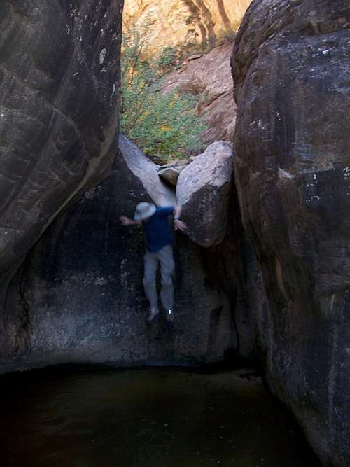
The canyon deepened and became narrower with some spectacular pine trees growing straight out of the cliff. The first real technical obstacle was either a jump or a scary traverse on some ledges. Adam and Mike opted for the scary traverse, while Stephen and I jumped, while being careful. This is not the place to break and ankle!
![Jump]() The Jump (taken on the second trip through).
The Jump (taken on the second trip through).
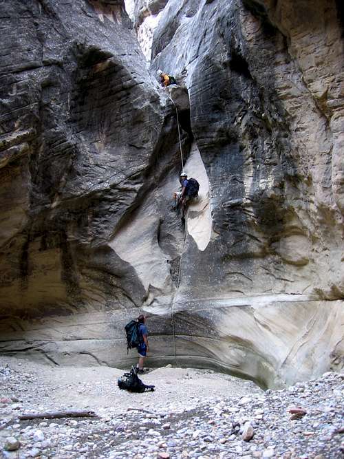
The first rappel was reached just after this. We climbed out to an exposed ledge where a tree provided a good anchor to rappel into the canyon below. The next rappel was not too far down canyon from this. Unfortunately there was a big patch of poison ivy to skirt before getting to the top of the drop. I hate poison ivy and am highly allergic. There were no solid anchors to rap off. Since I was first to this location, I went back up canyon and began to haul rocks down the canyon so we could construct a solid rap anchor. I piled the rocks against a small bush and buried them in the sand. The rest of the group joined in. It might look manky to someone whom isn't used to natural anchor systems, but it was solid and would be our rap anchor.
![Rapping down Outlaw Arch Canyon]() The rappel above the Arch.
The rappel above the Arch.Part VI-Outlaw Arch
I must also mention that from the top of the rap we could see it. Outlaw Arch. There it was, a huge arch hugging the wall of the canyon. Wow. This canyon was already a good one and now another surprise.
We completed the rap down to the floor of the canyon. After descending the rappel we could see just how big the arch was. I didn’t have my camera so I asked some of the others to take a photo. I thought the arch to have a span of 200-240 feet by eyeballing it. We thought it was a spectacular site but at the time, everyone’s main concern was getting out of the canyon and back to camp before dark. Since the sun was already setting by then and we still had a long way back to camp, so we didn’t have time to investigate it farther.
![Returning to camp]() Returning to Camp.
Returning to Camp.Part VII-We’re Out of Here!
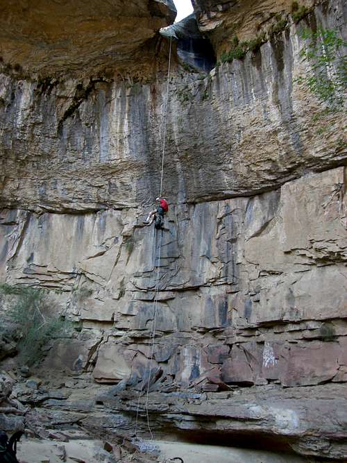
We finally reached the top of the next rappel. It wasn’t a bad rappel, but the rock is abrasive as we were now out of the sandstone and into a layer “carnivorous limestone”. At the top of the rappel the limestone sliced my leg open neatly. I don’t know why, but the blood trickling down my leg has a nice soothing effect and was pleasant rather than painful. Along with the breeze, it has a cooling effect and the neat cut was certainly a nice change from the jagged wounds and beatings that we had all experienced in the sandstone.
After repelling down the drop, there was one last ledge to climb over. We noticed an old cowboyglyph from the 1940’s. The river was only a few minutes away.
It was now a long wade up river and back to camp. The water felt good, but we reached camp right at dark.
[img:225789:aligncenter:medium:Returning to Camp.]
The next morning we climbed the Bighorn Route in Outlaw Canyon and set off for the trailhead and back home.
The Report
A few days after our discovery, I posted a brief trip report to the Canyons Group. They suggested we report the find to the Natural Arch and Bridge Society. It appeared that if my guess on the span was correct that it would become one of the largest known natural arches in the world. I reported the find and waited to hear back.
It was an exciting find, but to be official we would need a real and accurate measurement of the arch. After receiving instructions on how to do this, we would have to wait and go back.
The Return to Measure the Arch
I returned with Jeff Fox on September 30 2006 to measure the arch. I had borrowed an engineer tape and some other items from a coworker at work. Jeff and I chose a more direct but rugged route to the river and opted to attempt the entire trip in one very long day. Below is a map of our route:
[img:231939:aligncenter:medium:Map of our route. Click for full size.]
Here are some excerpts from Jeff’s own
trip report (please click on the link to read the full trip report):
When I read Scott Patterson’s forum post on 14ers.com about him needing help to measure an arch he and his group had discovered over Labor Day weekend in Dinosaur National Monument, I was thrilled! I had to go. Being that I’m a geologist and am always up for a new adventure, I thought this was a perfect opportunity for a new experience and maybe even the chance to be part of something possibly historic. I immediately sent Scott a message saying that I wanted to help out. I have been to that area once already. I camped one weekend by myself at Echo Park and hiked down to Mitten Park to see some structural geology that I had read about earlier; the Mitten Park Fault…….
……………After orienting ourselves, we gathered our gear and headed out. It was 8:30am. We moved along the cliff edge towards a canyon that we could descend to the saddle area between two peaks that would get us down another slot to the river. Once we descended into the first of several ravines, the real ‘fun’ began! The rock was mainly comprised of the Weber Sandstone formation. It is bare and gritty. On some of the steeper down-climbs, I was worried about slipping. Carrying 30+ lbs. worth of gear made the going that much more difficult in this rugged terrain. It wasn’t long before I slipped on some slickrock and began a belly slide. “Oh shit…oh shit!” I yelled to Scott who was already below me. My feet had gone out from under me while descending a really steep section of bare rock. Since it is sandstone, some of the surface is loose, sandy grit and is terrible for walking on. Scott had already slipped once, but lucky for him, it was on a relatively shallow angle with no drop below. I on the other hand, was now sliding belly first, towards a small bench (that Scott was standing on) before a 20’ vertical drop….I had to get stopped! Luckily, my fingertips were able to bite against the stone and I came to a halt before I bowled Scott over. I got up, dusted myself off and we continued walking. The only injury sustained was that I lost my fingerprints on my index and middle fingers and received a small tear in my pant leg! Ouch……………….
……………We were both completely dry from our river crossing due to the extreme aridity of the terrain. This was a good thing too, because we had finally come to one of the crux areas of this trip. Scott explained to me that we’d now traverse a narrow ledge, approximately 3’ wide that had about a 600’ vertical drop to the right. “You don’t want to slip here.” he told me. I think that was the understatement of the century!..............
…………………The going was brutal. Up and down, up and down we went. Just when you think you are heading down for good, you must climb again. There is no such thing as a ‘direct-route’ in Dinosaur National Monument. There is no use in measuring distance ‘As the crow flies’ here either. That thinking doesn’t work. All that is here is rock, boulder, cliff, canyon, cactus and sun. The land forces you to go in certain directions; where it wants you to go. In doing so, we became water, following the path of least resistance ever downward into this ancient, sun scorched labyrinth of tortured stone…………….
…………….Trodding ever downwards, we came to an area where we saw a bench above and to our left. Scott thought perhaps this might lead to the top of the arch. We dropped our packs and backtracked a bit to find a place to gain the ledge. The only way up onto it was to climb and traverse an exposed section of bare rock. This took some patience and concentration so as not to fall. Once up on the bench, we walked along it for about 100m and sure enough, we were on top of the arch……………
…………………We began by locating the spot on the closest end of the arch where it came into contact with the cliff wall behind it. From there, we ran a 100’ engineer’s tape along the top as close to the gap as we cared to get. From our vantage point at the end of the arch, it appeared that it was touching the wall at about 88’ from the end. However, I walked down to this point and straddled the arch/cliff gap and discovered that it indeed did not touch the wall! So, we ran the tape out again and marked the end. 100’. From there we ran the tape out again and marked the end again. 200’. At that point we ran it out to a spot where the arch did come into contact with the wall at a total of 206’. If there had been no contact at this point, the arch could have easily measured another 60’ possibly.
We took many photographs and checked our measurements carefully. The gap between the arch and the cliff behind it is only about 2’ wide in places. It goes down to about 1’ in other places, but is definitely big enough to fall through if you’re not careful! I had to be extra cautious while straddling the thing to get some of the pictures. Needless to say we were excited about this measurement! This puts the arch at being the 9th largest span in the world! After we were finished, we placed a cairn at each end of the arch. What an exciting day indeed!....................
Please read the full account in the link.
The trip up river was more difficult than the previous trip because the river was higher. On the plus side, we found another smaller albeit interesting arch on the way back and on the climb out. We got back to the vehicle way after dark.
Aftermath
To sum it up, the arch we discovered turned out to be the 13th largest known natural span in the world and one that wasn’t discovered until 2006. Finding it and measuring it were both and adventure.
We have found many different things in the isolated canyons in this region. While exploring, we often find an occasional hidden waterfall, numerous hanging gardens, wonderful pools, several arches, etc. We are used to coming onto new surprises, but this one is special and exciting because of its size and the interest in the area it has generated.
It proves that all the exploring in the world is not over yet, but there are still wild and unexplored areas that still await exploration and discovery, even in our own backyards. The area is a real maze of complicated routes. We never know what new thing we might stumble upon when exploring these isolated canyons and peaks.
I must mention that the arch might not be that unknown for long. The arch has been featured in newspaper articles and in one magazine. Mike Kelsey, a member of the original team is also a guidebook author and is going to include the arch in his next book, Technical Slot Canyons of the Colorado Plateau, 2nd edition. Even so, this arch will never become a popular tourist attraction in the foreseeable future. It is a rugged and technical adventure with a very complicated route and in a very isolated area. It will remain visited by the relative few climbers who are out for a challenge.


Comments
Post a Comment