
-
 8732 Hits
-
 80.49% Score
-
 12 Votes
|
|
Route |
|---|---|
|
|
47.81300°N / 112.799°W |
|
|
Hiking, Mountaineering |
|
|
Summer |
|
|
Half a day |
|
|
Class 2 |
|
|
Overview
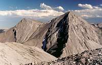
The east ridge and north slopes make a gentler alternative to the northwest ridge. I used it as my descent route but would not like climbing it due to the amount of steep, loose scree one will encounter-- just no fun to me. However, people preferring hiking to scrambling and wishing to avoid the occasional exposure and the awkward footing of the northwest ridge should enjoy this one.
It is about the same length as the Northwest Ridge route, so expect 4-4.5 miles of hiking, about 3600’ of elevation gain, and maybe two to four hours of hiking to reach the top.
Getting There
About 5 miles north of Choteau on U.S. 89, a paved road indicating skiing and fishing access heads left. Take it. About 17 miles later, take a left turn that shortly crosses the South Fork Teton River and becomes a gravel road. This is the South Fork Teton Road, and you follow it through increasingly pretty scenery for about ten miles to a parking area at its end. Along the way, you will have occasional views of Rocky Mountain to the southwest, and it is also visible through the trees at the parking area. These glimpses will give you some chances to assess conditions on and near the northwest ridge and decide if it suits your tastes. The parking area is about 1 mile past the turnoff for the Mill Falls campground and recreation area. Mill Falls takes only a few minutes to see and is pretty but not heart-stopping. On the right side of the road at the parking area, you will find the trailhead for Headquarters Creek Pass and Our Lake. You will want to head for the pass. These roads are passable for passenger cars.Route Description
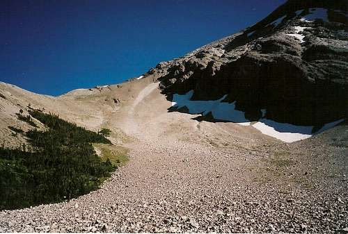
Hike towards Headquarters Creek Pass, about 2.8 miles away and 1949' of elevation gain. The first half of the hike is mostly gentle and winds through an unexciting forest that yields few views, but look for wildlife for both your enjoyment and your safety. About halfway along, the trail follows high along the canyon's edge, and you can enjoy the suddenly open and enticing views of the canyon, two beautiful waterfalls, and the mountains. Soon you will make your second of three stream crossings on this trail (easy crossings in July, but some, especially the first, might be troublesome April-June), this one being a little bit below the base of one of the waterfalls.Now the trail reveals its trick-- you pick up most of the elevation gain along the second half, making this trail harder on your legs than dividing the elevation gain by the miles might suggest. As you climb the several switchbacks waiting for you here, start being alert for mountain goats; you are now entering their country, and they seem to have a knack for knocking rocks down in the direction of hikers and climbers. Shortly after the third stream crossing, you enter a lovely subalpine basin full of rock and snow and dominated by the northern face of Rocky Mountain. This is a nice place to catch your breath, snap some photos, and sip some water. This also the end of the approach.
View from the upper portion of the basin
FROM THIS POINT IN THE DESCRIPTION, THE ROUTE PERSPECTIVE CHANGES-- Because I used the east ridge as a descent route, I have described it from that perspective. However, the route is easy to follow, and one should not have trouble “following in reverse.” Once you enter the basin below Rocky Mountain’s north face, the way to go up is should be obvious.
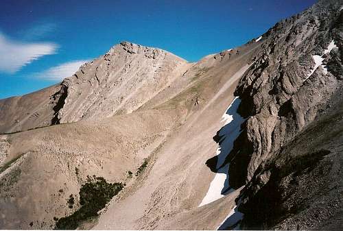
From the summit, head down the east ridge until you are at or close to its lowest point and then take the scree slopes down into the subalpine basin the trail passed through earlier. Often but not always, the scree is small and loose enough to "ski" down it. It took me 75 minutes to climb the northwest ridge; my descent via the east ridge and the scree slopes back to the main trail took 35. Once back on level ground, walk a few minutes until you pick up the trail. If you look for the trail while descending and keep your bearings, you can avoid any reclimbing to reach the trail. NOTE-- when descending the scree, stay between the complicated north face of Rocky Mountain and the obvious rocky spur extending northward from the saddle at the lowpoint of the east ridge. If you have the Our Lake quad with you (you should), aim for the stream that leads to the spring along the trail at 7050'. If you go down on the right side of the rocky spur, you will likely find yourself bushwhacking and dealing with cliffs in order to regain the trail.
The scree slopes, and the way down (or up)
Essential Gear
- Plenty of water-- it gets hot out here.
- Sturdy shoes
- Trekking poles (helpful but not necessary)
- Bug repellent for mosquitoes and a fast pace or body armor for the flies
- Pepper spray and knowledge of how to use it-- stay away from here and all of the northern Rockies if you don't know how to act and react in grizzly country properly. If you don't know exactly what I mean, then you need to stay away instead of putting yourself and, consequently, the bears, at risk.