
|
|
Route |
|---|---|
|
|
42.32130°N / 117.8744°W |
|
|
Hiking |
|
|
Spring, Summer, Fall, Winter |
|
|
Less than two hours |
|
|
4WD drive up |
|
|
Overview
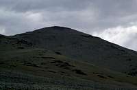 Blue Mtn
 Since this area of the state is a long way from anywhere, you might consider adding this peak to your agenda. Of course, it only is of value if you are chasing the Oregon Prominence peaks (see link below)but it just seems a natural to get this one while you are in the area.
If you have a high clearance 4WD vehicle, you can add one of Oregon's 73 prominence peaks to your trip to the Stevenson BM. Blue Mtn is the dominant peak to the northeast and is very accessible to US 95. Be warned that even if you have high clearance, you might be more comfortable parking about midway up and hoofing it to the top.
At 7435 feet high, Blue Mountain is a dominant appearing mountain as you travel south from Burns Junction. From the north, it stands out for miles and lures you towards it. Antenna structures await you and of course they are the reason that a road was built in the first place. Great views in all directions and a Benchmark is located on the southeast part of the peak. As with the Stevenson BM situation, there are no campgrounds nearby but you could probably find some place off of the road near the pass that you could park and spend the night.
 The top & our vehicle
Getting There
 Blue Mtn Map
 Access is fairly easy as the road you need to take is just off of US 95 at the summit of Blue Mtn Pass. You access the road about 33 miles south of Burns Junction or 22 miles north of Mcdirmitt. At Blue Mtn Pass, look for a dirt road that heads west from the pass. Follow it as it makes its way up the mountain, parking at the top.
 Blue Mtn Benchmark
Route Description
 Heading up the road
 As mentioned, in the right vehicle, you just drive up the road that leads to the towers. The last half mile is pretty rough with a drop off that might intimidate some drivers. There is a couple places lower down that you could park and walk the road to the top and if you don't have high clearance, you could walk this one from near the bottom. Cattle are present in the lower area so be watchful as you drive from the highway to the summit road.
TOPOZONE MAP