
-
 22592 Hits
-
 74.92% Score
-
 5 Votes
|
|
Route |
|---|---|
|
|
42.44500°N / 122.3142°W |
|
|
Hiking |
|
|
Spring, Summer, Fall, Winter |
|
|
Most of a day |
|
|
Tough Hike |
|
|
Getting There


This route starts just east of Fish Lake about 200yds east of Milepost 31 or about .5 mile east of the Fish Lake turnoff. I parked on the north side of the highway. Elevation here is about 4,828 ft.
Route Description

The first 2 miles is through an old growth forest in the Sky Lakes Wilderness Area. The forest isn’t very thick and it is easy to pick your way through the trees. When you have gone 2 miles and gained about 1,500 ft you will emerge from the forest at the bottom of a long open slope that goes all the way to the summit. You can clearly see the summit 3,200 ft above you and the route is to just walk up the obvious clear area.

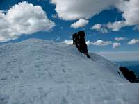
The route steepens as you climb towards the summit and it can be icy the last 2,000 ft. This is where it will be nice to have your crampons along. The summit usually has a cornice hanging over to the north and you can walk on the top of it. If the snow is too soft, you will probably turn around way down in the forest because you will be wallowing in snow drifts.
There may be avalanche danger on the upper part of this route if there has been a recent heavy snow storm. If there has been a snowstorm, wait until the snow consolidates before attempting this hike. This hike is best done in the Spring. During the summer this slope is a miserable lava, talus, and scree trudge that may be more dangerous because of the loose rocks.
This total hike is only about 7.5 miles round trip and gains almost 4,700ft. The day I climbed it the snow was soft because the weather had been warm and it took me almost 9 hours to complete the hike. The best part of the climb is that you can glissade from the summit. If the snow is good you can glissade down to about 6,800 ft before the slope flattens out. I only made it down to about 7,600 ft because the snow was too soft. Some people ski or snowboard from the summit.
Essential Gear
