|
|
Mountain/Rock |
|---|---|
|
|
47.60882°N / 12.27602°E |
|
|
Hiking |
|
|
Spring, Summer, Fall, Winter |
|
|
6552 ft / 1997 m |
|
|
Overview
The Pyramidenspitze is a summit in the Kaisergebirge, which is placed in the northern part of tirol, close to the boarders to germany. The Kaisergebirge is diveded in two parts. Zahmer Kaiser and Wilder Kaiser are separated by a small valley, the Kaisertal.
 |
 |
The Pyramidenspitze is a highly frequented summit at the Zahmer Kaiser ridge. After the however to most people unknown 2002m high Vordere Kesselschneid it is the second highest, but the most well-known summit of the Zahmer Kaiser ridge. Sothwards and Westwards the Pyramidenspitze is connected to a plateau which is marked by mountain pines and karst formations. To the northwest and northeast it is bordered by the Egersgrinn and Winkelkar, which are two possible routes to the summit.
Getting There
There are four possible starting places to the summit. Depending on the route you choose, you can start at:- Kufstein (Eichelwang)
- Ebbs (center)
- Ebbs (Buchberg)
- Walchsee (Durchholzen)
The most common starting place is in Walchsee.
Comming from Innsbruck, drive along the highway A12 to Kufstein (about 80km).
Use the Exit "Kufstein Nord". At the traffic circle go left, then follow the street B171. Pass the villages Ebbs, Niederndorf, Sebi. At Durchholzen, when the street turnes hard to left, you will find parkering area on the right. There is no parking tax.
Comming from Rosenheim use the highway to Austria. After the exit "Oberaudorf", follow the street through the villages Niederndorf and Sebi. At Sebi you will reach the main street B171. The further way is described above.
Routes to the Summit
As mentioned above, there are four possible routes to the summit.- Route Kaisertal - Kufstein (Eichelwang)
- Route Kaiserwald - Ebbs (center)
- Route Egersgrinn - Ebbs (Buchberg)
- Route Winkelkar - Walchsee (Durchholzen)
Route Winkelkar:
The standardroute leads through the Winkelkar. Starting place is at Durchholzen. Follow the signs to Winkelkar and the path up the mountain.
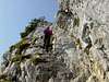
Make sure to have head for height. The last few hundret meters end in a fixed rope route.
Map Route Winkelkar
Durchholzen - Großpointeralm - Winkelalm - Winkelkar - Pyramidenspitze
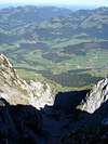
Route Pictures:
 |
 |
 |
If you want to add a detailed Route describtion with hyperlink, leave a message with the ID of the describtion - I will include.
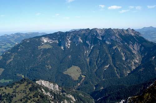
Other peaks in the area
Naunspitze - 120min - 1633mPetersköpfl - 90min - 1745m
Einserkogel - 60min - 1924m
Vordere Kesselschneid - 20min - 2001m
Overview:
Digital air photograph
Take care:
The trips look rather easy. There are no technical difficulties, but in summer it can get very hot and there is no opportunity to find any water!
Camping
Usually camping is not necessary. There are a few hut around, offering accomodation and best food.huts and links:
Vorderkaiserfelden Hütte
phone: +43/(0)5372/63482
Ritzau Alm
phone: +43/(0)5372/63624
Guesthouse in Ebbs
Maps & Links
KaisergebirgeKompass Map WK9
1:50.000
Kompass Verlag
ISBN: 3-85491-011-8
Digital map for Hiking and Mountaineering
Digital air photograph
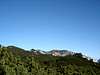
Other mountains around
 |
 |
 |