
-
 20658 Hits
-
 90.3% Score
-
 32 Votes
|
|
Mountain/Rock |
|---|---|
|
|
42.66810°N / 103.3306°W |
|
|
Dawes |
|
|
Hiking, Scrambling |
|
|
Spring, Summer, Fall, Winter |
|
|
4410 ft / 1344 m |
|
|
Overview
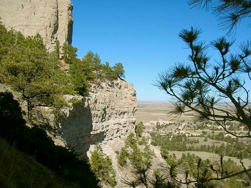 Steep sides all around increase the challenge
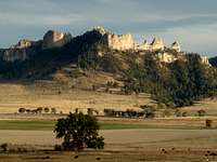
Crow Butte helps to dispel the image of Nebraska being just treeless plains. The site of a major 1849 battle between the Crow and Sioux tribes, it rises almost 900 feet higher than the White River, five miles northwest. A feature article on the history of Crow Butte was written in the Chadron Record newspaper. According to Lists of John, Crow Butte has 340 feet of prominence and is the 14th ranked summit in Nebraska. Calculation from the National Elevation Dataset would place Crow Butte as one of the top 10 steepest summits in Nebraska. Like many of the good summits in the state, Crow Butte is on private lands. For those who have climbed Crow Butte, there is pretty much a consensus that this is one of the very best summits to climb in the state. The climb is challenging, the views are outstanding and the history of the area makes it all that much more interesting..
 Moonshiners Cave
Bighorn sheep and deer are seen on Crow Butte, and there are occasional sightings of mountain lions on automated game cameras near the butte. Rattlesnakes can be a problem on some parts of Crow Butte, except during winter. The owner of the land on the butte’s north side reported there is a rattlesnake den in the middle of the burned trees there. A small dry gully is located on the east side of Crow Butte. On the east wall of this gully is the remains of an old cave. This is all that is left of the infamous "Moonshiners' Cave". During Prohibition years, this cave originally had two rooms that housed a moonshine liquor operation. Old-timers in the area used to have many stories to tell about fights and troubles with the owner of the moonshine operation. The end of Prohibition also brought the end to the troubles. Years later, the land was sold and the new owner used dynamite to close off the cave.
The Fires of 2012
 Crow Butte's west side during the fire
 Crow Butte's west side after the fire
Over 200 square miles of Nebraska forests and meadows were destroyed in the major fires of 2012. This led to temporary closures of state parks and wildlife management (WMA) areas, as well as large portions of the Nebraska National Forest. Winter Storm Atlas in October, 2013 further compounded the damage to the forests in the area. Crow Butte did not fare as bad as some of adjacent areas in Nebraska’s Pine Ridge, but still sustained damage from both the fires and the storm. There are some risks of snags in the forested areas of the butte. Since it is all on private property, it is even more essential that would-be hikers and climbers make sure they have permission to hike and climb on Crow Butte.
Getting There
Crow Butte can be reached by county roads, either from Highway 20, or from Highways 2 & 71. Squaw Creek Road runs along the west side of Crow Butte, while West Ash Creek Road runs along the north side. Since Crow Butte is just a few miles southeast of Crawford, probably the best thing for visitors to do is stop at the National Forest Service office at 125 North Main Street in Chadron and pick up a map of the area. Chadron is around 25 miles east of Crow Butte, on Highways 20 & 385. The forest service map will show main roads and back roads, plus where public and private property lines are at. They will also be able to help you determine who currently owns the land around the butte, and advise you on how to contact the landowners for access permission.
Route Information
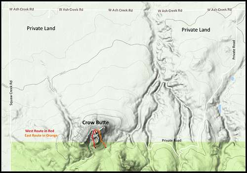 Crow Butte Climbing Routes
The greatest difficulty in reaching the summit is a combination of soft rock that is sometimes unstable, along with the extent of the sheer sides around the butte. There are routes on both the east side and the west side that make the summit accessible, but both routes lead to the same access point on the north ridge. For those who have climbed Crow Butte, there is pretty much a consensus that this is one of the very best summits to climb in the state. It could probably be rated a Class 3+ climb. The 400-foot climb is challenging, the views are outstanding and the history of the area makes it all that much more interesting.
 Crow Butte Autumn
Which property owner that you obtain permission from to climb Crow Butte will largely determine your route and distance to where you begin climbing. As you can see on the map, probably the best place to start either route is from somewhere along the south side. If you have to bushwhack in from the west or north, it may just be easier to pick up the route at the ravine between the butte and the rock spires immediately to the west. The western route will likely take a little longer considering the terrain, but it is the best side of the ridge to scramble to the summit.
When To Climb
Crow Butte is adjacent to prime hunting land, and so each spring and then again in fall the hunters turn out in large numbers. This is another good reason to work out timing with permission from the local land owners. Of course weather will also be a major consideration, so you will want to be up-to-date on the local forecast by clicking here:Crow Butte - Fort Robinson Area Weather
Unexpected Finds
 Predator Victim's Bones
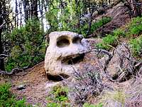 Mysterious Face Boulder
Coming down the western side of Crow Butte during a 2007 climb, we found a radio tracking collar in the bottom of a small ravine. Just a little further down the ravine, we found the skeleton of a bighorn sheep. After returning the collar to the nearby Ponderosa Wildlife Management Office, they investigated the matter. Later, we were informed the sheep had been at that location for about two years, before some predator killed it. Game biologists speculated the bighorn was killed either by a mountain lion or a pack of coyotes. Since that time, the mountain lion population in this region has grown significantly. Nebraska game biologists continue to track the lion population in the Pine Ridge area from Chadron to Crawford. It serves as a reminder that solo hiking in the area, without any means of repelling lions, is certainly risky.On another Crow Butte hike, our group was hiking on a game trail in the forest just east of Crow Butte, when we came upon a boulder that looks like a "face". We could not tell if this was a natural occurrence, or had been chiseled by humans long ago. Whatever caused it, the weathering indicated that it happened a very long time ago.
Red Tape
 Crow Butte Geodetic Marker
Crow Butte is entirely on private property. So, when you pick up your map, you will save time by checking to see who owns the property on the route you choose to take. A Dawes County Plat map, available at The Chadron Record newspaper office, can help with that. It is very essential you obtain permission from the property owner before you attempt to climb Crow Butte. The friendly staff at the Nebraska National Forest Service Office in Chadron can sometimes help with this as well.
The landowners around the butte have had problems with trespassers and irresponsible hunters and hikers, so do not assume this is a step that can be bypassed.Crow Butte Outfitters may be the quickest resource for obtaining permission for a climb. You can access their website by clicking here: Crow Butte Outfitters
Camping & Lodging
 Evening on Crow Butte
 Forest East of Crow Butte
There are a variety of campgrounds in the area. The closest are at Crawford and at Fort Robinson, only a few miles away. The Crawford Chamber of Commerce (308-665-1817) and the main office at Fort Robinson (308-665-2900) can each give you more specific information on camping locations, services, and rates. There are also excellent camping facilities at Chadron State Park, 30 miles east. You can get complete camping information for Chadron from the Chamber of Commerce office there (308-432-4401). You can also try these links:
Maps
Crow Butte lies in the USGS Crow Butte Quad. The Nebraska National Forest Map for the Pine Ridge is a good map for the area, and can be purchased at the Nebraska National Forest office in nearby Chadron.