
-
 13467 Hits
-
 79.46% Score
-
 11 Votes
|
|
Mountain/Rock |
|---|---|
|
|
39.15420°N / 105.5835°W |
|
|
Park County |
|
|
Hiking |
|
|
Spring, Summer, Fall, Winter |
|
|
11570 ft / 3527 m |
|
|
Overview
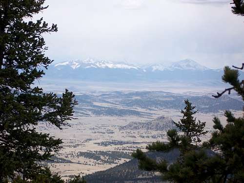 Pikes Peak Massif in the distance
At 11,570 ft, "Puma Peak" is the highest peak in the Puma Hills. The Puma Hills are low, wooded mountains between the geological feature known as South Park and Tarryall Creek. The unofficially named "Puma Peak" is in the north Puma Hills, which run north from Wilkerson Pass. The area provides habitat for mountain lions (aka puma), pronghorn antelope, black bears, bighorn sheep, mule deer, and elk. The nearby Tarryall Creek valley boasts a rich history including that etched by German immigrant farmers. "Puma Peak" is one of seventy-three peaks in the state of Colorado with at least 2000 feet of prominence.
Puma Hills: The Puma Hills are low, wooded mountains between the geological feature known as South Park and Tarryall Creek. The area provides habitat for mountain lions (aka puma), pronghorn antelope, black bears, bighorn sheep, mule deer, and elk. The nearby Tarryall Creek valley boasts a rich history including that etched by German immigrant farmers.
Colorado Rank: 1,514th highest mountain in Colorado
Colorado 11ers: 201st highest 11er in Colorado
Prominence: 2260 feet
Rank & Prominence Source: Lists of John
NOTE: SPer Jeremy Hakes notes that there is disagreement as to which summit is the highpoint of "Puma Peak." Some content the eastern highpoint (with a stated elevation of 11,550 feet on the map) is actually higher that the western summit (that appears, per the map, to be the highpoint). Ensure you visit both "humps" to be thorough!
Getting There
 Moody Clouds
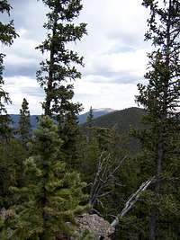
From Colorado Springs: Hwy 24 West to Lake George. Just past lake George, turn right (northwest) on Park County 77 (Tarryall Road). Use caution with the minefields of potholes. Between dusk and dawn, deer and elk are incredibly numerous - watch your speed! Just before the Tarryall Reservoir, turn left on Park County 23 (Turner Gulch Road). Follow Park County 23 1.6 miles and turn left onto FS 144. Take FS (Forest Service Road) 144 4.5 miles to the junction with FS 237. Bear left/east at this junction and continue until a parking area where the road makes a sharp right, crosses a stream (Pack Creek) and heads into deep woods. There is no sign for this trailhead. Parking is ample with respect to the small volume of fellow trail users.
From Denver: Take Hwy 285 to the town of Jefferson and turn left on Park County 77 to the Tarryall Reservoir. (Keep an eye out for free range cattle.) Just southeast of the reservoir turn right on Park County 23 (Turner Gulch Road). Follow Park County 23 1.6 miles and turn left onto FS 144. Take FS (Forest Service Road) 144 4.5 miles to the junction with FS 237. Bear left/east at this junction and continue until a parking area where the road makes a sharp right, crosses a stream (Pack Creek) and heads into deep woods. There is no sign for this trailhead. Parking is ample with respect to the small volume of fellow trail users.
For Park County 23 and FS 144, high clearance is a must but 4x4 is a nice-to-have unless the roads are wet. If the roads are wet, do not proceed without 4-wheel drive.
Puma Peak: Standard Packer Gulch Route
Camping & Lodging
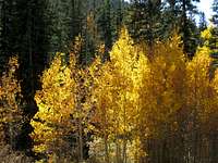 Colors ablaze
 Courtesy of Jeremy Hakes
 Fall colors
Courtesy of Jeremy Hakes
Camping
Plenty of camping can be found along Park County 77 and spur roads off of it.
Near Packer Gulch Trailhead
Plenty of rustic 4x4 camping can be found along FS 144 and spur roads off of it. Be advised that this camping will most likely be "dry camping"; bring plenty of water.
South end of Hwy 77
The south end of Hwy 77 (Tarryall Road), near Hwy 24, provides several established U.S. Forest Service camping areas. South Park Ranger District Lake George Area Campgrounds include: Riverside, Spillway, Happy Meadows, Round Mountain, Spruce Grove, and Twin Eagles. Please contact the district office at 719-836-2031with additional questions about the campgrounds in the South Park Ranger District.
North end of Hwy 77
The north end of Park County 77 and dirt spur roads are abound with off-road campsites. Several campsites off Rt 39 provide views of Mt. Silverheels, Buffalo Peaks and other 13ers and 12ers that will bring tears to your eyes. With these 4x4 campsites, remember to bring plenty of water, bury human waste and pack our what you packed in.
Cabins, Lodges and Hotels
Numerous cabins can be rented in and around Lake George. There are also a few cabins/lodges along the Tarryall Creek catering especially to the fly fishing visitor. For example: Ute River Ranch. There are a few hotels in Fairplay.
Weather & Seasons
“Puma Peak” is primarily accessible from late Spring through Fall. Winter access is limited when snow makes the Forest Service approach roads impassible. During shoulder season, it is recommended the hiking party place a call to the South Park Ranger District to inquiry about road conditions prior to setting out. Additionally, due to the off-trail nature of this hike and the ample dead-fall, snow-shoeing or skiing to the summit of “Puma Peak” would not be particularly pleasant.External Links
Pike & San Isabel National ForestsPike National Forest Recreation Map
Colorado Springs Gazette: Happy Trails, Puma Peak
Red Tape, Restrictions, etc.
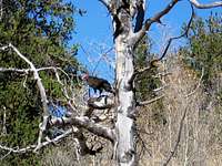 Turkey Vulture
Courtesy of Jeremy Hakes
Bikes, horses and dogs, dirtbikes, quad-runners...it's all welcome on the logging road. Virtually no usage restrictions exist. Only on-foot travelers leave the old logging road and visit the summit. Follow LNT (Leave No Trace) principals and be courteous of other recreationalists. Note that while the people visiting this area are a little less "REI" and a little more "Hook 'n Bullet", the summits are primarily wild and trail-less and provide for amazing solitude.
ericnoel - Apr 21, 2007 10:58 am - Hasn't voted
Comments...I realize this page is still under construction but I have two suggestions anyway. First, the coordinates and thus the topozone link are off by a bit. Depending on datum you want something like: 39.1542 and -105.5835. Secondly, you might want to note that this peak is one of the 73 in CO with 2000 feet of prominence: http://www.ryananderin.org/lists/prominence.html That P2000 status makes it a somewhat important mtn to people who go after prominence peaks and may be worth noting in the page's text.
Sarah Simon - May 4, 2007 4:14 pm - Hasn't voted
Re: Comments...I appreciate the inputs. Making updates shortly.
Jeremy Hakes - Sep 25, 2010 8:13 pm - Voted 10/10
Summit location is off per Roach.Per Gerry Roach, the summit area is the other one (11,550). In his book, "Lost Creek Wilderness", they checked and double checked and backsighted, but it appears the map is incorrect. I didn't go over to the (incorrect) summit area, just the high one. LOJ.com has it noted correctly.
Sarah Simon - Sep 29, 2010 7:54 pm - Hasn't voted
Re: Summit location is off per Roach.Jeremy, I will make a note that there is some disagreement as the the actual highpoint and to hit both the eastern and western highpoints to be sure. Thanks!