
|
|
Area/Range |
|---|---|
|
|
43.44494°N / 113.5437°W |
|
|
Hiking, Scrambling, Skiing |
|
|
Spring, Summer, Fall, Winter |
|
|
7729 ft / 2356 m |
|
|
Central Idaho's Inferno
Central Idaho's Craters of the Moon National Monument and Preserve has been called "the strangest 75 square miles on the North American Continent" It gets its name from the seemingly endless craters, lava flows and piles of loose rock. The area's terrain is so other-worldly that the Apollo astronauts even trained here in preparation for their moon missions. The monument boasts sixty lava flows and 25 cinder cones as well as what is called the Great Rift, a 62 mile-long crack in the earth's surface. The last volcanic activity in the area is said to have occured nearly 2,000 years ago. Craters of the Moon highpoint
A few years ago the size of the monument was more than doubled and it now takes in even more features, stretching almost to the Snake River in the South. There are only a few miles of road and the vast majority of the monument is a roadless, trailess, desert wilderness of sharp black lava rock. It is jointly managed by the National Park Service and the BLM. The Park Service manages the lava flows while the BLM manages the grass and sagebrush portions.
Craters of the Moon is also known for its extensive system of underground lava tubes and is popular amongst cavers.
Durning the winter Craters has a good amount of cross country ski trails groomed and is the destination for many skiers.
The weather can range from extremely hot (near 100 degrees) in the summer to extremely cold (often below zero) in the winter.
Craters of the Moon is situated at the Southern tip of the Pioneer range and is quite high in elevation. There are also great views of the Lost River Range to the Northeast.
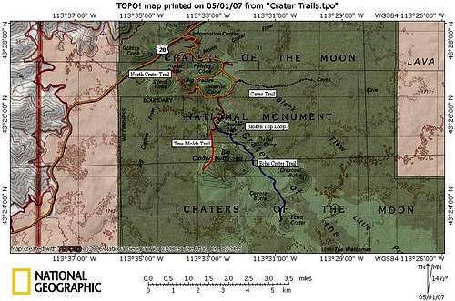
Only the northern end of the monument has development of any kind. There is a visitors center/museum and a few picnic sites as well as a few hiking trails. The trails range from nearly 5 miles long to only about 1/4 mile long and take you to many of the most interesting sites in the monument.
Geology
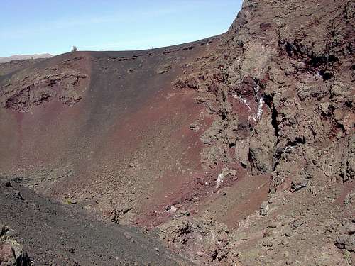 Big Crater with Interesting Geology
Craters of the Moon is a very interesting area geologically. The oldest lava flows in the park are near 15,000 years old while the youngest are only 2,000 years old. It consists of 3 major flows (from North to South): Craters of the Moon Flow, Kings Bowl Flow, and the Wapi Flow.
Craters' origins are closely linked to the surrounding areas: the Snake River Plain and Yellowstone National Park. It is beleived that the Snake River Plain was formed, beginning around 15 million years ago, as the North American Plate moved Southwest over a stationary Hotspot. As the plate continued to move the hotspot would produce cataclysmic eruptions leaving a trail of volcanic calderas behind. Most of the lava that is visible on the plain is Rhyolitic which is usually associated with more explosive eruptions. Craters of the Moon, however, is predominantly Basaltic which is less explosive. The hotspot was directly below Craters of the Moon around 10 million years ago and today is below Yellowstone National Park. This means that someday Yellowstone could look much like Craters does now.
For more detailed information on the geology of this region click on the BLM site or on this link.
Getting There
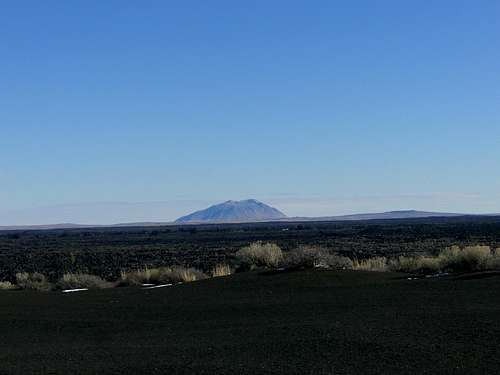 Big Southern Butte near Craters of the Moon.
From Idaho Falls
Take US Highway 20West to Arco, Idaho. When you get to Arco just follow the signs. You will have to make a left turn right in the center of town onto US 2693. Once you do that you just drive strait until you get there. The highway goes right through the northern section and the visitors center/entrance is just off the highway. There is nothing else but lava so you can't miss it.
From Twin Falls
Drive North to Shoshone on ID 75. Once you get there turn right onto US 2693. There should be a sign directing you to the monument. You will eventually pass through the town of Carey, Idaho and the monument boundary is just past that. Then you will come to the visitors center a few miles later just off the road.
From Boise
Take I-84 south to Mountain Home and exit onto US 20 going East. Just stay on this highway the whole time until you get to Carey, Idaho. Take a right turn at the T and soon you'll be in the monument and see the entrance on the right side of the road. It's about halfway between Carey and Arco.
For different kinds of maps of the route there as well as of the park click here.
 Getting to Craters
Things to Do
 A Cave Entrance
Hiking Trails
Inferno Cone .5 Mile
 Inferno Cone
Devil's Orchard .25 Mile
This is an interesting loop hike that is very short, only 1/4 a mile if even that. It goes around an area where the lava encased trees and burned them, leaving black "tree trunks" of rock. There is also a picnic site here.
North Crater Flow Trail .5 Mile
 Desolation
North Crater Trail 2 Miles
This trail is a little bit longer and provides a better look at some of the features of the monument. The trail circles North Crater and passes through it's crater as well. You'll want to have someone park your car at the other end since it's not a full circle unless you want to hike back.
Tree Molds Trail 1 Mile
This trail takes you to a place where lava engulfed a forest. When the trees caught fire they burned and eventually decayed away. The lava was left standing in the shape if the tree trunks with the tree's imprints inside.
 Tree Molds
Echo Crater Trail 8 Miles
This trail enters and provides access to the backcountry of Craters of the Moon. It starts at the end of the road going to Broken Top. On it's way to the crater it passes Buffalo Caves as well as Broken Top. You may backpack in and camp at Echo Crater. For this trail you will need a backcountry permit that is available at the visitors center.
Broken Top Loop
This trail takes you around Broken Top cone and past a great variety of features. It starts in the same place as the Echo Crater Trail and the Tree Molds Trail.
For more information about these trail visit the Hiking Trails section of the official monument site.
 Trails in Craters
Caves
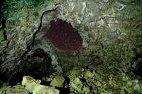 Great Owl Cavern
There are a great many lava tubes in Craters of the Moon and the majority of them are easy to access. There are a few more remote caves and some that are more challenging than others. A 2 mile trail goes along the area where the majority of the popular caves are found. For detailed information on each cave click on this link. There is another group of more remote caves to the south called the Buffalo Caves.
Winter Activities
During the winter the Loop Drive is groomed and open to cross-country skiers.It is about 5 miles long. You are also permited to ski off the groomed trail and down the slopes of some of the cones. There is no charge for skiing the Loop.
Visit the skiing/snowshoeing section of the official site.
Summits
Although Craters of the Moon is not a large mountain range it does offer a substantial amount of volcanic cones and buttes to climb, most of which are probably not particularly difficult to climb. The difficult part comes in getting to the remote ones as there are no roads and VERY few trails. The terrain is horribly broken and sharp and the climate is quite inhospitable so even with the lack of technical routes these cones present challenges in other ways. Probably the most challenging aspect of these cones is that there are no trails on any of them except for one. (Inferno Cone) under usual circumstances this wouldn't be a problem but here the sharp lava rock is an issue to take into consideration. I have included only the mountains that have fairly easy access up to this point.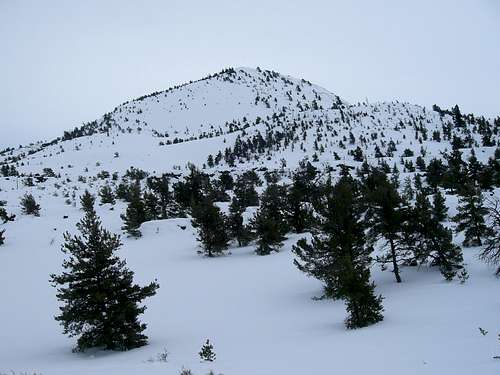 Big Cinder Butte
Easy Access Mountains
Craters of the Moon High Point 7729 ft.
The highest point within the park boundaries lies in the foothills of the Pioneer Mountains near the Northern boundary. It is unnamed Pt. 7729. To access this mountain go across US. Highway 20 from the visitors center and follow the road leading around Sunset Cone to the group campsite. Continue on up Cottonwood Creek to the end of the road and climb up to the high point of the ridge from there.
Sunset Cone 6410 ft.
Sunset Cone is the first cone you will see on your right as you come into the monument from Arco. It is best climed fro the east and could probably be accessed from the group site on the Northeastern slope.
Grassy Cone 6315 ft.
Grassy cone is on the North side of the highway just past Sunset Cone. It would probably be easiest to climb from the North or South sides.
North Crater 6244 ft.
 North Crater
Paisley Cone 6107 ft.
This mountain is just Southeast of North Crater and the road runs right at its base.
Paisley would best be climbed from the road to the east.
Silent Cone 6357 ft.
Silent Cone is just Southwest of North Crater. The North crater trail goes between it and North Crater. This Cone would be best climbed from that trail.
Red Tape
 Lava Arch
Also, you will want to bring some REALLY sturdy shoes as the rocks are extremely sharp.
It is a good idea to stay on the trails because it is very easy to get lost, fall in a hole or crack, or break a leg in the uneven and jagged lava. Don't go exploring the backcountry by yourself unless you are very experienced in this kind of thing.

Camping
There is only one 52-site overnight camping area in the monument which is near the visitor's center. The fee is $10 per night per site. If you come in the early or late season it is only $6 per night per site because there is NO WATER. There is also a separate group site for $30 a night. The rest are day-use picnic sites only. Map of the developed area.