Overview
![North Burro GPS track]() GPS track of the tour
GPS track of the tour
18-miler ski tour to N. Burro 12,680 ft, in a little known corner of Uinta Wilderness. We wondered if it has ever been skied before.
Poor visibility and flat light make for a very few pictures, and so I think that the preferred format is a TR rather than a mountain / mountain group page. But Scott Patterson offered to dig up some summer shots from his Eastern Uinta trips, so a new mountain page remains a possibility.
Planning a ski tour in Beaver Creek
![Flat Top just below the 3-way...]() That's what the ideal Uinta spring ski terrain may look like (Flat Top Mountain in May 2005, when it warmed into the 50s at the ridgetops)
That's what the ideal Uinta spring ski terrain may look like (Flat Top Mountain in May 2005, when it warmed into the 50s at the ridgetops)
When the spring weather gets warm and mid-elevations no longer refreeze well at nights, the best skiing terrain in the Uintas is usually meadows and plateaus near, or above, the tree line. The plateau snow is compacted by the winds, and it lasts longer, and remains quite firm even during warm spells.
So when we think spring skiing, it is usually about the long, gentle, treeless Northern spur ridges of the main Uinta range. We've skied a variety of these high ridges in the years past. In May 2007, Mike was looking for something new, and noticed a couple of spur ridges separating the tributaries of Beaver Creek. With the major summits like the Burros or Coffin, all just shy of 13,000 ft, the area was an absolute
terra incognita for me.
Michael Kelsey's "green book" on Utah mountaneering mentioned that the main Hoop Lake road (off MP 123.5 on WY 414, that's a mile and a half East of the hamlet of Lonetree) is an OK road but not plowed in winter at all. As to the spur roads to Middle and West Forks of Beaver Creek, Kelsey's verdict was just "forget it if it's wet". Well, after a late-April warm spell, we should be able to drive to the general area of
Hole-in-the-Rock. Once there, we'll see.
Reconnaissance in force
Mike, Judy, and myself met in Salt Lake at 4:45 am on 5/6/07. The grey dawn met us in Wyoming prairie, all dusted with fresh snow from a weekend storm. The storm has by now moved in Colorado, but forecast for the Uintas predicted more Sunday morning snow from the storm's wraparound band. The highland section of WY 414 was all snowbound, but down in Lonetree it didn't stick to the pavement.
Instead of using the Hoop Lake road described by Kelsey, we turned to the familiar Henrys Fork road from Lonetree (near MP 122) ( Until 4 or 5 years ago, it was the recommended way to get to the winter trailhead for Kings Peak, but we've since switched to the route from WY 410 to get there). The Henrys Fork road was also signposted to Hoop Lake. In two miles, as the Henrys access road turned West, we continued straight South towards Utah state line. By the way, in winter, this route may be be better than the one described by Kelsey, since there is
a farm just South of the state line and the road is likely plowed to within 3.5 miles of Hole-in-the-Rock. At the Beaver Creek bridge, the two roads connected, soon to split again near the Hole in the Rock GS. After a very short discussion we turned West into Middle Fork, in hope that this track gets more sunshine than the narrow gorge of Hoop Lake Fork, and we may be able to take Mike's Subie a bit further in. In most places, only a few inches of new snow covered the track, but in the shade of the range it was appreciably deeper. We passed the junction with the steep North Slopes road (Kelsey's "forget it") and parked
at the edge of the meadows, some mile and a half short of the summit TH, So far so good!
Thompson Peak 11,776
![Middle Fork Beaver Creek]() Middle Fork Beaver Creek
Middle Fork Beaver Creek
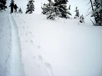
The low snowclouds hang overhead. It was just below freezing, but here and there, muddy puddles hid below the fresh snow. We crossed Middle Fork. No base yet, it looked more like early fall than like spring conditions. The road switched back and ended in a summer TH parking lot, and we set off on a horse trail, across a meadow and along a burbling creek, cussing an occasional rock or muddy spot.
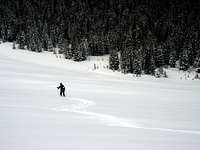
![Judy breaking trail]() Is it treeline at last?
Is it treeline at last?
Then the base got better, and almost as quickly, we lost the Beaver Lake trail, not a mile away from the TH (the trail apparently switched back to the right, while some ribbons marked something unclear to the left). It was a clear case of blessing in disguise! Unbeknowst to us, we were now on track to shortcut to the high ridge of Thompson Peak.
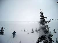
We cut an upward traverse to the South-East and soon entered
a gully, where the trees opened at last. Up the gully to the South-West, we soon reached the little flat above 10,000 levels, then ascended another slope to the Hill 10,325. Trail breaking was getting quite heavy, and the visibility was totally missing, so I had real trouble convincing Judy and Mike that the treeline is close. Even though the GPS said so. Well, it was just a beginning of a long day of GPS navigation.
![Breaking trail up Thompson]() Up the North Bowl of Thompson Peak
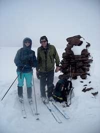
Up the North Bowl of Thompson Peak![Thompson Peak 11,776]() The summit cairn
The summit cairn
We ascended South in a steady clip, and finally, the trees parted. A wide powder bowl beckoned ahead, with just 800 more feet to gain to our first summit of the day.
A traverse to the left, towards Burnt Ridge, then to the right along the ridge, and we relaxed at the top, at 11,776 elevation. It was 1:30 pm, the wind was blowing snow, and we couldn't see much around. According to the GPS, North Burro Peak was two miles away to the South, but even during the moments of the best visibility, we could at most see the lower slopes of our next destination.
North Burro 12,686
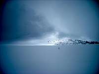
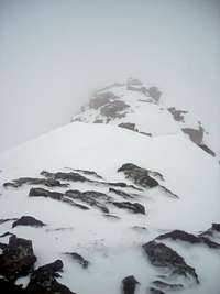
![Rare sunray on Burros]() A moment of unrivaled visibility: the ridge leading to the Burros can be guessed at the lower left
A moment of unrivaled visibility: the ridge leading to the Burros can be guessed at the lower left![North Burro summit]() Judy approaching the summit (in the foreground). Nice view (ahem)
Judy approaching the summit (in the foreground). Nice view (ahem)
We had first to drop almost 400 ft to Thompson pass. The 1,250 ft ascent beyond the pass started gradually at first. Then, in three quarters mile from the still-invisible destination, we skinned up and zizagged along the still-guessable ridge, then threw a long switchback into the milk to the right. Once I turned left again, the slope gradually started to ease, and at times we could guess some boulders to the South, perhaps on the West ridge of North Burro. In a third of a mile from the top, we meandered through these boulderfields - so it wasn't the ridge after all. It was blowing pretty hard, and the 12,500+ altitude was making itself felt by now.
![Kabell Ridge of N Burro]() Kabell Ridge as seen from the top
Kabell Ridge as seen from the top![North Burro]() Mike on Burro: Hurray, now let's get out of here!
Mike on Burro: Hurray, now let's get out of here!
A gently ascending band of snow to our left looked inviting, but at a closer look into the inpenetrable milk it looked kind of like a cornice edge, so we crossed another band of boulders to the right. Now this one definitely WAS the ridge! A couple hundred yards later we stood at the summit - the high point of a narrow East-West ridge with a steep bouldery slope to the South and, yes, a mighty cornice blocking whatever remained of the view North.
The wind erased a good deal of our tracks, so on descent we had to consult with a GPS a few times again. In the flat light and without any landmarks, it wasn't a very pleasant ski glide. The soft windcrusts cracked spookily a few times, the eyes were strained to the limit, and the wind was getting at the nerves in an un-springlike way. Still it was a fun feeling ... the highest summit to ski since Kings Peak a month ago, and no booting whatsoever this time!
Back over Thompson
![North bowl of Thompson]() Powder ride to the treeline
Powder ride to the treeline![Soft powder on Thompson]() Judy skiing from Thompson
Judy skiing from Thompson
It was 5 pm when we stood at Thompson Pass again. We weren't sure at first if really want to reascend the 350 ft to Thompson, or to bypass it. But a powder bowl ride was impossible to resist, so we crawled on up :)
Yes, the fluffy soft snow on Thompson's North side, virtually untouched by the winds, was great - and we even had a few moments of the best visibility so far, all the way to Hole-in-the-Rock some 5 miles away to the North.
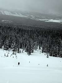
![Lower Thompson Bowl]() Finally, a view all the way to our carpark!
Finally, a view all the way to our carpark!![View towards Hoop Lake Fork]() View towards Hoop Lake fork
View towards Hoop Lake fork
Back in the trees, our morning track was now covered by an inch or two of featherlight powder, and the glide down was fast and fun all the way to 9,500 level. Further down, the snow wasn't powdery anymore, and the trees and then rocks and puddles were in the way, but still we made it all they back on skis - if a few minutes too late to get to Evanston Discount Liquor before it closed for the night at 10.
Now I just wish I could see all these unknown peaks we've just climbed!
Comments
No comments posted yet.