
|
|
Route |
|---|---|
|
|
53.07206°N / 4.08005°W |
|
|
Hiking, Scrambling |
|
|
Spring, Summer, Fall, Winter |
|
|
Half a day |
|
|
Scrambling to Grade 1 |
|
|
Overview
Usually used as the second part of the Snowdon Horseshoe and a descent from Snowdon the route offers a hugely enjoyable ascent of the mountain. Y Lliwedd is one of Wales iconic rock faces and although largely ignored by the climbing fraternity today, it was the birthplace of British rock climbing. This route is around 6km long, has around 950m of climb and takes the eastern ridge of the peak before descending into Bwlch y Saethau and ascending Snowdon via its South Face.
Getting There
The starting point for the Lliwedd Route is the Pen y Pass car park (SH 647 555) at the zenith of Llanberis Pass, which can be reached easily by road on the A4086 that runs between Llanberis (SH 582 598) and Capel Curig (SH 719 580).
Owing to the popularity of the route the Pen y Pass car park often fills up quickly so if you want to park there a very early start is recommended. Luckily there are other options, the first of these is an excellent park and ride which runs regularly all day (including weekends and bank holidays) from Nant Perris (SH 607 582). The second option is the Snowdon Sherpa bus service which has various stops around the mountain and runs from Llanberis, Bettws y Coed, Caernarfon, Beddgelert, Bethesda and Porthmadog. Be sure to check timetables first as you don't want to end up missing the last bus and find yourself stuck, of course in these situations hitching is always an option.
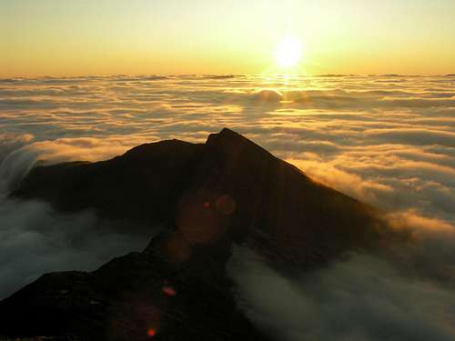 Y Lliwedd (Photo by tphubbard)
Route Description
The route begins at the Pen y Pass car park (SH 647 555) and follows the Miners Track southwards past Llyn Teyrn to the causeway that crosses Llyn Llydaw (SH 634 545). Here it deviates southwards from the Miners Track crossing a metal footbridge and gently begins to ascend the eastern slopes of Y Lliwedd. Care is needed to keep to the more distinct path that takes the walker up the East Ridge rather than the less distinct path that heads in a more westerly direction and terminates at Lliwedd's precipices, which should only be attempted by experienced rock climbers.
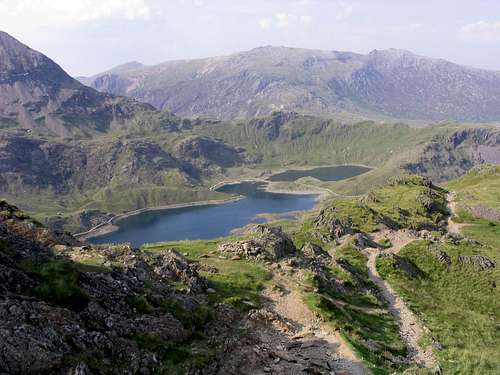 Looking down the lower section of the eastern slope
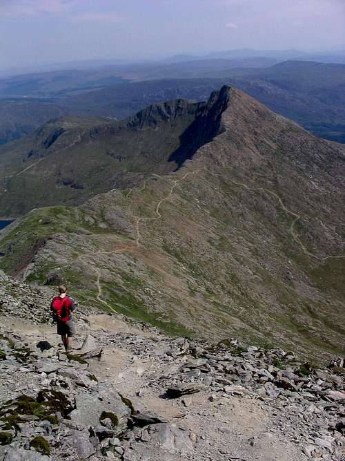
From here on the slope becomes steeper and rockier, passing through a col (SH 639 535) that separates Y Lliwedd from Gallt y Wenallt. Here the slope becomes even steeper and rockier turning the path into a Grade 1 scramble. The route closely follows the crest of the ridge to the East Summit (SH 623 532) where it traverses to the West Summit by crossing a slight depression before descending some 100m into Bwlch y Saethau (SH 615 540). From Bwlch y Saethau the route attacks Snowdon's summit via its south face. The south face is largely made up of loose rock and scree which has numerous paths zigzaging across it, this makes route finding in poor weather extremely difficult and the walker is best advised to take a quick bearing aiming-off onto the southern side of Bwlch Maen (SH 606 538) and then following the crest of the ridge northeast to the summit.
Essential Gear
Just a good pair of boots, waterproofs and some lunch. If walking in winter make sure you also carry an ice axe and crampons.
Maps
OS 1:25k Explorer Series OL 17 Snowdon/Yr Wyddfa
OS 1:50k Landranger Series 115 Snowdon/Yr Wyddfa
Harvey Map Services 1:25k: Snowdonia North: Snowdon, Glyders, Carnedds
Harvey Map Services 1:25k: Snowdon
Harvey Map Services/BMC 1: 40k British Mountain Map: Snowdonia North
Road Maps
OS Travel Map 10 Wales/Cymru & West Midlands
Guidebooks
Snowdonia (Official National Park Guide) by Merfyn Williams
The Mountains of England and Wales: Volume 1 Wales (Cicerone Guide) by John and Anne Nuttall
Hillwalking in Wales Vol 1 (Cicerone Guide) by Peter Hermon
Hillwalking in Wales Vol 2 (Cicerone Guide) by Peter Hermon
Hillwalking in Snowdonia (Cicerone Guide) by Steve Ashton
Ridges of Snowdonia (Cicerone Guide) by Steve Ashton
Scrambles in Snowdonia (Cicerone Guide) by Steve Ashton
External Links
Y Lliwedd from Snowdon
Government Bodies and Official Organisations
Snowdonia National Park Authority
Association of National Park Authorities
Royal Commission on Ancient & Historical Monuments in Wales
Hiking, Climbing and Mountaineering Organisations and Companies
British Mountaineering Council
Plas y Brenin National Mountain Centre
Weather
Tourist Information
North Wales Tourism Partnership
Local Information from Gwynedd.com
Local Information from Snowdonia Wales Net
Travel
Welsh Public Transport Information
Accommodation
Youth Hostel Association in Wales
Maps and Guidebooks
Cordee Travel and Adventure Sports Bookshop
Wildlife and Conservation
Joint Nature Conservation Committee
Royal Society for the Protection of Birds