Introduction
We all know the height of a summit is one of the most important factors in its appeal to a climber. But for me the overall quality of the experience matters more than just the height. Given a choice to climb the highest and most famous mountain in a range, which lots of other people will do that day, versus a more obscure peak that is only almost as high but where it is likely I will see no one else, I am inclined to procrastinate the higher one to some future time, perhaps in the off-season.
So despite the feeling that I could by now claim to have been on the highest summit in Utah, nearby King's Peak, I was happy that when my parents-in-law (Tim and Julie), who are avid hikers, visited town, they suggested Gilbert Peak for the hiking trip my wife (Christy) and I were going to take with them while they were here. King's can wait.
Backpacking or day hiking?
Our original plans were for some sort of backpacking trip somewhere in the Uintas, and as it turned out (you will see), backpacking on this particular route would probably have been a better idea, but Tim, who is on the one hand a marathon runner capable of covering vast distances in a single day, and on the other hand known for packing discouragingly heavy loads on backpacking trips (full of camera and ham radio gear) made what we decided was a convincing case that we could do a Gilbert Peak loop hike in one day as long as we left the trailhead early enough.
With the help of some over-optimistic assumptions that neglected vertical distance and made liberal use of cross-country shortcuts, we estimated a total distance of 17 miles. No problem!
The mile-wide ridge
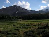
![north ridge]() Here is the ridgetop seen from the upper section where it rises to the summit of Gilbert
Here is the ridgetop seen from the upper section where it rises to the summit of Gilbert
We arrived at the Henry's Fork trailhead/campground at dusk on Friday July 6, and set up tents in the parking lot next to the car since the the campsites were full. We got a 6:30 AM start Saturday morning and had a pleasant and uneventful hike to Elkhorn Crossing, where we stocked up on water since we were about to leave the canyon bottom.
A bit past the crossing a trail forks to the left and leads to the Joulious Creek and North Side Highline Trails. We followed this briefly and then left it to ascend directly to the broad flattish north ridge of Gilbert Peak which the trail backtracks to circumvent.
![our route to the ridge]() Our route to the ridge
Our route to the ridge
We found a very usable goat trail up to the ridge, and spent the next several hours enjoying the alpine meadows and wide-open space at the top of Utah. I liked this part a great deal.
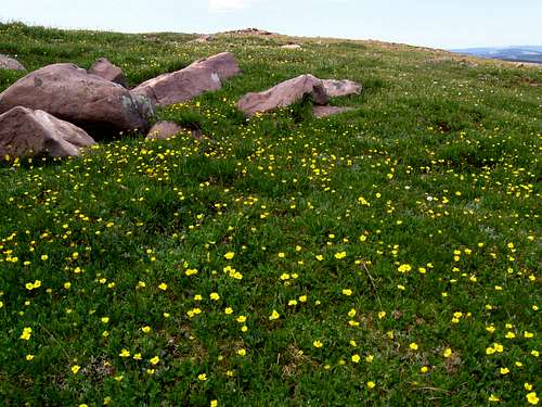
![buttercups near Gilbert Peak]() buttercups gently illuminated by a brief moment of sunshine
buttercups gently illuminated by a brief moment of sunshineThe summit
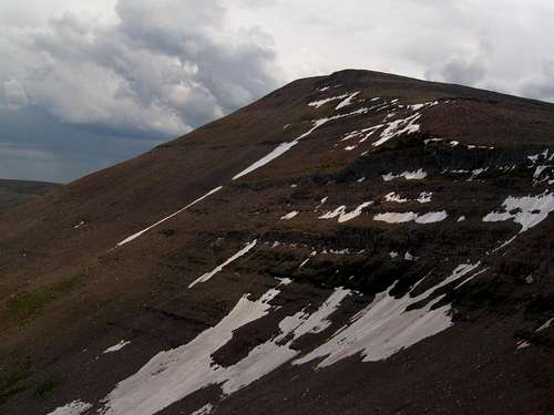
![north face of Gilbert Peak]() Gilbert Peak
Gilbert PeakThe first indication that we were at risk of not making it back by nightfall was when around 12,500 to 13,000 feet Christy got a splitting, throbbing altitude headache and we had to slow the pace down. She had not been this high before! I was feeling the effects too. During a food break a plastic bag escaped in the wind and I sprinted to chase it down. I caught the bag, but in exchange for my breath, which I lost and became amazed at the speed of my breathing; that thin air encounters very little resistance on its way in and out of one's lungs. I am "used to" (not the right word) the Eleveners near Salt Lake City (and my wife, who grew up at sea level, is usually fine below 10,000 feet); I had certainly never sprinted above 12,000 feet! Closer to the summit, I noticed myself feeling as though I had had a couple of drinks: a bit fuzzy in the head. It was just enough to add to the number of ways I could say I was high: the altitude (obviously) and the sheer incomparable joy and satisfaction of approaching a summit in a beautiful place being the others.
Tim and Julie got ahead while I stayed back a bit with Christy who was saying she had never had such a bad headache, and nearly collapsed a couple of times from light-headedness. Although I encouraged her to drink water and eat something, and she assured me she had done so, it was not until we finally arrived at the summit and she had more time to eat and drink and rest that she began to feel better.
![Gilbert s north face]() Gilbert from the north ridge
Gilbert from the north ridge
The weather was partly cloudy with indications of possible rain which never materialized, but with the sun coming in and out, and the variety in the sky, I really enjoyed the soft patches of light on the slopes and meadows. Gilbert Peak itself, viewed from the north ridge just below, was an impressive sight against the blues and grays of the sky.
Views of the surroundings were also nice.
The descent
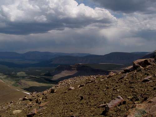
![North Fork of Uinta River valley]() North Fork of Uinta River Valley; I loved the lighting I was trying to capture here
North Fork of Uinta River Valley; I loved the lighting I was trying to capture here
We finally began our descent at around 3 pm, which means that we were giving ourselves about 6 hours of daylight to go a distance greater than what we had just taken around 8 hours to do. (The descent distance was greater because we still intended to take the loop route instead of going back the way we came)
![north face from east ridge]() North face of Gilbert Peak viewed from the east ridge
North face of Gilbert Peak viewed from the east ridgeWe started down the east ridge, which was a fun, slightly exposed scramble, but since we didn't know it was going to be a scramble rather than an easy talus-hop, we were already getting behind on our speed expectations. Near the saddle, between 12,000 and 12,500 feet, we dropped off the ridge and descended at least a thousand feet of talus to the basin below, at the head of the canyon formed by the West Fork of Beaver Creek. This too was slow going, because Julie, who had done fine on the way up, was now experiencing the effects of the runner's knee symptoms she had begun having a few weeks prior. She has been running for years, but this year has done more half-marathons than usual. Some sections of the slope were loose and soft, but generally opportunities for nice fast plunge-stepping in the dirt were few. It was 5 pm before we even got to the uppermost lake in the basin, where we restocked on water and had some food.
![spine on east ridge]() the spine on the east ridge that we scrambled down
the spine on the east ridge that we scrambled downBy the way, if you want a mediocre photo to end up as Photo of the Hour on SP, just submit it between 2 and 3 am. That's what, to my bewilderment, happened to this one of the ridge spine we scrambled down, but even so, the computer algorithm appears to have different taste than I do, because I posted my other (not quite so mediocre, I hope readers will agree) Gilbert photos at the same time.
With my knees actually working reasonably well (they don't always, thanks to my brief attempt in recent years to become a distance runner), and Tim (who could have run the entire loop by now if not for us slowpokes) absorbed in his ham radio scanning, I had gotten down the slope significantly before the others, and took a few minutes to sit down and just take in the view, listen to the breeze and the stillness, and sort of meditate for lack of a better word while the others caught up. When the others caught up, I joked I'd had a religious experience, and we all laughed, feeling like who needs religion when you can have such deeply sublime sensations as hikers and mountaineers commonly experience in these amazing settings, without any obsolete dogmas getting in the way?
![Gilbert Peak]() Looking back at Gilbert
Looking back at Gilbert
Looking back towards Gilbert Peak on the way down the basin gave an impressive sight; the basin straddles the 11,000 foot mark, leaving roughly 2,500 feet of vertical space for Gilbert's summit pyramid to fill. As evening progressed the sky became clearer and the sun, lower in the sky now, brought out a dazzling green in the grasses of the basin below the peak. My feeble attempt to capture this (left) compromised a bit on the foreground color brightness to keep the sky from getting too washed out.
![moose]() the moose
the mooseLater, after losing my sunglasses (dangling insecurely from my pack chest strap), Christy's sunglasses (probably similarly fastened), and Julie's bifocals while jumping over marshy spots near the lakes, we saw four moose.
Are we there yet?
Still not having reached the North Side Highline trail, and with dusk approaching, and having by now more accurate (i.e. discouraging) reappraisals of the distance back over the ridge we had ascended, across a drainage or two, and back to either the Henry's Fork trail or, via part of the Joulious trail, to the road which we could then follow back to the campground, it was sinking in that we were in for some extended flashlight/GPS navigation (we had not brought any kind of bivy gear).
For my part, the appeal of the alpine setting had pushed this reality out of my mind until now. Perhaps the others were the same, because in a short time we went from enjoying the hike to a predictable succession of dysfunctional psychological states: disbelief that it could really be that far, a need to assign blame to someone for picking the particular destination, or route, or for not wanting to do it over two days, or for underestimating the distance, or for letting themselves get talked into such things, fear of running out of batteries while off-trail in the forest, bears in the dark, or of running out of stamina or food, and even an irrationally noble request to be left behind so as not to burden the others.
This part was over pretty quickly though and we accepted that we would be hiking for approximately half the night and we just had to agree on whether it was more important to follow a trail the entire time (to minimize route-finding risk) or to take a more direct route to save time. Fortunately, Tim had set a series of GPS waypoints for a possible cross-country route more directly back to camp, because as it turned out, the trails were too intermittent to follow in the dark without any navigation instrument. We were also lucky that our route had some significant sections of open meadows during the time when the sun was down but there was still enough light outside the forest to see without aid. I found it enjoyable to walk through these meadows in the almost-dark; our surroundings were very pretty.
We approached the edge of the ridge we were supposed to cross to get back into Henry's Fork around the time it was getting too dark to see even in the clearings. There is not a great deal to say about endless meandering through forest by flashlight and GPS (which frequently went crazy losing and regaining satellites, but still served as an overall indication of our progress towards waypoints), occasionally finding a trail to follow that seems to go more or less in the desired direction but then fades away before too long, just trying to put one foot in front of the other because you're too sleepy, tired, and stiff-jointed to spend much energy either doing more, or resisting acceptance of your predicament. The highlights for me were (a) nausea every time I stopped walking, I guess from such sustained activity supported by trail mix, crackers, cookies, bars, and bagels; and (b) a certain stream crossing:
We'd had an ongoing debate whether it would be better to follow the Joulious Creek drainage on the east side of the creek all the way back to the road, and still have a southwardly backtrack along the road to the trailhead, or to attempt to cross the creek in the dark, aiming for a more direct route. The terrain answered the question for us: when we had gotten down the slope into the drainage, the creek was too near and the vegetation too thick to make much progress downstream. That and Tim found what he thought was a good-enough way to cross: a log leaning up from our side at at least a 30-degree angle across to the other side. He started climbing up it, while I was eyeing some subsurface rocks I thought we could stand on with the aid of my trekking poles.
I just remember him giving a hand to Christy to help her up and across the log, and not too surprisingly to me (hence my interest in the other method), but no doubt coming with rude suddenness to them, the log broke and they both fell into the water, fortunately staying on their feet. They scampered to the other side, and Julie and I went ahead uneventfully with the use of the trekking poles. The bright side Christy later pointed out once the cold had subsided, was that for feet that had been walking in boots for 17 or 18 hours by now, the water was a refreshing change.
Finally
At last at about 1:15 am, we arrived at the road, much closer to the trailhead than if we had stayed to the east of Joulious Creek. Fifteen minutes of a combination of dissatisfaction with the fact that we were still walking when we felt like we were supposed to be done, but growing relief that we actually could for the first time make accurate and encouraging predictions about how much time we had left and exactly which direction (straight ahead) the tent was, and we were there.
The total time since departure from the trailhead was 19 hours (over I would guess around 25 miles), long enough, in my opinion, to mock the notion of it being a "day hike." But the way I look at it is the stiffness, soreness, tiredness, hunger, Julie's preexisting knee pain, and Tim's bruised ankle (from dislodged talus) were all temporary. Even Julie's bifocals were recovered, when two days later Tim ran back up the trail to look for them. He didn't find them, but he found a boy scout troop which he enlisted to look for them, and they found them. At this point I remember the adventure and thrill of a great hike more than the discomfort.


Comments
Post a Comment