
|
|
Mountain/Rock |
|---|---|
|
|
40.08220°N / 107.0964°W |
|
|
Garfield |
|
|
Hiking, Mountaineering, Scrambling, Skiing |
|
|
Spring, Summer, Fall, Winter |
|
|
12133 ft / 3698 m |
|
|
Overview
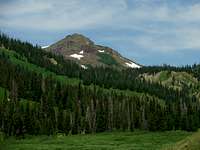
Orno Peak lies on the wilderness boundary of the Flat Tops Wilderness in the Routt National Forest. Orno is the fourth highest peak and is the northeastern-most twelver in the Flat Tops. The peak provides great views of much of the surrounding area including the Park Range, the Gore Range, the Elkhead Mountains, and much of the northern and western Flat Tops, to name a few. The peak is accessible for day trips but can easily be incorporated into longer outings in the Flat Tops. Orno seems to be somewhat popular based upon the summit log; the peak sees anywhere from one to two dozen summits a year. During the summer wildflowers can be found throughout the higher elevations, including the summit of Orno. However, take care, as the mosquitoes during the early summer can be horrendous. On the Summit of Orno Peak
The Flat Tops Wilderness is the second largest wilderness in Colorado. The Flat Tops Range page has a good overview to the area including some geology information. An excellent page on Colorado geology can be found here. The mountains of the Flat Tops are high points among a vast region of flat topped land made from eroded lava flows on top of the White River Plateau. This area is like no other in Colorado. The Flat Tops are also known for their incredible fishing and the ability to take excellent long distance trips in the wilderness.

This page will include information on the peak mainly from the Yamcola Reservoir side of the peak. It should be noted that the peak can also be reasonably accessed from the Ripple Creek Pass and Dunckley Pass areas. More detailed information on these areas can be found on the Pagoda Peak and Pyramid Peak pages, respectively.
Getting There
From the town of Yampa on Colorado State Route 131, turn west onto Routt County Road #7, also known as Moffat Ave in the town of Yampa, at the Conoco gas station. This will lead you onto the main drag of Yampa. Continue through the town for a few blocks and exit town on RCR #7. Follow this road to the national forest where it becomes FR 900. FR 900 leads to the Yamcola Reservoir and the Stillwater Reservoir. This area is very popular and has many places to camp, fish, and hike, among other activities. From the Yamcola Reservoir, take the first right after crossing the dam onto FR 906. Follow this dirt road to its end at the trailhead. Orno from Devil's Causeway
Red Tape
Standard National Forest and Wilderness Regulations apply. Orno Peak is on the boundary of the Flat Tops Wilderness. Summit Ridge
Camping
 Orno from Flat Top Mountain
 Orno from West Coal Creek
There are many places and many different types of camping available near Orno Peak. The Routt National Forest operates several fee campgrounds near Orno Peak on the Yamcola Reservoir side of Orno:
Bear Lake
Horeshoe
Cold Springs
These sites require fees but have some facilities available for campers.
There are also a multitude of impromptu campsites along FR 906, the access road to Orno Peak’s trailhead. These sites had everything from tents to fifth-wheel trailers in them. These sites did not seem to be fee sites, but as such did not have any facilities.
Also, there is always backcountry camping in the National Forest and Wilderness. The nearby Mandall Lakes are highly recommended; they include spectacular forests and terrain combined with incredible fishing.
Routes Overview
 Southeast Ridge
 Southeast Ridge Map
Southeast Ridge
The southeast ridge of Orno is a curving ridge that provides an excellent day-hike from the Yamcola Reservoir side of Orno. The route does not have an established trail or path for the entire route and requires some navigation skills.
Length: 6 to 8 miles, depending on specific route
Elevation Gain: 2,100 feet, assuming start at trailhead
Difficulty: Class 1 and 2
 West Ridge
Other Route Possibilites
There are many other route possibilities to climb Orno Peak. Options could include ascending from the Little Flat Tops and the western ridge from Mandall Pass. Approaches could vary from the Sheriff’s Reservoir and Ripple Creek Pass areas. It would be possible to include Orno into a long-distance backpacking trip through the Flat Tops.
 Flat Tops from the Hike Up Mandell Pass
External Links
Current Weather Forecast for the Orno Peak AreaNational Operational Hydrologic Remote Sensing Center Snow Information
Nearby Weather and Snow Station
Larry V - Jul 18, 2009 8:48 pm - Voted 10/10
County high pointAddition: I think it's worth mentioning that the 12,027' high point of Rio Blanco County is on Orno Peak. 99% of Orno Peak is in a different county, but Orno's northwest arm extends into Rio Blanco County. I attached a topo map and photo showing said high point.