
|
|
Area/Range |
|---|---|
|
|
40.95077°N / 115.12256°W |
|
|
11306 ft / 3446 m |
|
|
Overview


The East Humboldt Range, named by the explorer John C. Frémont for the German naturalist Alexander von Humboldt, is located in northeastern Nevada and runs north to south for about 30 miles. The majority of the range lies within the borders of the Humboldt National Forest.
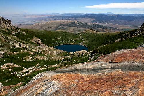
The East Humboldt Range bears close resemblance to its larger neighbor to the south, the Ruby Mountains. Secret Pass separates the two ranges. U-shaped canyons, moraines, and steeply carved granite mountains, cliffs, and cirques, attest to the glaciation from recent ice ages. Angel Lake, Smith Lake, Greys Lake, and Winchell Lake to the north, and Lizzie's Basin, Boulder Lakes, and Steele Lake in the central section comprise the glacial tarns in the range.
The lowest elevation in the range is 5,650 feet, at the northern end towards the town of Wells. Greys Peak (10,674 ft.) is the northernmost summit of the range and Humboldt Peak (11,020 ft.) is the southernmost high summit. At 11,306 feet, Hole in the Mountain Peak is the highest point in the range.
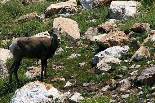
The range is home to mule deer, mountain goats, bighorn sheep, coyotes, mountain lions. This range, along with the nearby Ruby Mountains, are also the only places in the United States that are home to the Himalayan snowcock, introduced in the late 1960s.
East Humboldt Wilderness Area
Congress designated 36,000 acres of the East Humboldt Range and the Humboldt National Forest as the East Humboldt Wilderness Area in 1989.Getting There
The easiest and most popular access route is via NV Hwy 231, also called the Angel Lake Scenic Byway. From Interstate 80 about 1 mile west of Wells, take Exit 351 onto Hwy 231. Hwy 231 winds for 12 miles and terminates at Angel Lake, just past the campgrounds. This entire stretch is on a paved road.About 4 miles prior to reaching Angel Lake, you can turn left off of Hwy 231 onto the Angel Creek access road. This road will lead to Angel Creek after about a mile.
Another entry point, Weeks Access, leads to an area known as Lizzies Basin. Take U.S. Hwy 93 south from Wells for about 5.5 miles; turn right (west) onto NV Hwy 232. After about 2 miles, Hwy 232 curves south and runs along most of the east side of the range before turning into County Hwy 782 (dirt road) and connecting with Hwy 93 near the southern end of the range. After about 8.5 miles on Hwy 232, take a right at Weeks Access Road and head west. This USFS access road traverses private land; be sure to stay on the road and use it only for its intended purpose, to get in and get out. A 4WD, high clearance vehicle is required to reach Lizzies Basin.

Hiking & Camping
Hiking trails run from Angel Lake to nearby Smith Lake and from a trailhead near Angel Lake down the east side of the range to Winchell Lake and Lizzie’s Basin. Another trail runs from Secret Pass near the south end up the west side of the range and around to Angel Lake.Developed campsites are available at the Angel Lake and Angel Creek. See the External Links section for fees and additional information. Primitive camping is permitted at no fee.
Red Tape
USFS regulations apply. At Angel Lake, there is a $3 day use fee for parking. Angel Creek is also a fee area. Refer to the External Links section for additional information on fees. Firearms may be carried (open carry only and not concealed) in a holster.Wilderness area rules apply in the East Humboldt Wilderness Area. Backcountry hiking and camping do not require any permits. There are no roads in wilderness areas. Mechanized transportation, including mountain bikes, are not permitted. All travel must be by foot or horseback. You will find no logging, resorts nor commercial uses of any kind except for grazing.
Food & Lodging
The town of Wells is located at the north end of the range and should have adequate lodging. Elko, about 50 miles to the west on Interstate 80, is a good alternative. There are a large number of hotels there. I think the best deal in Elko is at the Stockmen’s Hotel and Casino. As of July 2007, a room with two twin beds went for $39.50. The rooms have AC, refrigerator, bathtub, hairdryer and many have a balcony. The hotel has a nice swimming pool and food is available 24/7 in the casino’s restaurant located right next to the hotel lobby. The Stockmen’s is located at 340 Commercial Street in Elko; 775-738-5141. The Commercial Casino (775-738-3181) is right across the street from the Stockmen’s and their restaurant (the Brand Room) has a great dinner buffet Tuesday through Saturday, 5pm-10pm.Phone Numbers
Humboldt-Toiyabe National Forest: 775-331-6444Ruby Mountains Ranger District: 775-752-3357
Elko County Sheriff Dispatcher: 775-738-3421
Fire Dispatcher (to report wildfires): 775-738-5137
Nevada Division of Wildlife: 775-738-5332
Nevada Highway Patrol: 775-738-8035
External Links
Humboldt-Toiyabe National Forest - Ruby Mountains Ranger DistrictRuby Mountains Ranger District Campgrounds and Trailheads
hgrapid - Dec 31, 2010 12:10 pm - Voted 10/10
Greys Peak Deleted?Greys Peak was deleted? I will recreate if you have no objection.