
-
 26741 Hits
-
 78.1% Score
-
 9 Votes
|
|
Area/Range |
|---|---|
|
|
44.91640°N / 111.46°W |
|
|
Hiking, Mountaineering, Trad Climbing, Bouldering, Scrambling, Skiing |
|
|
Spring, Summer, Fall, Winter |
|
|
11316 ft / 3449 m |
|
|
Overview
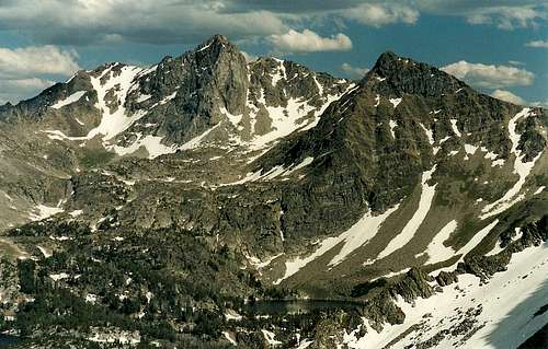
 "Jerome Rock Peak" in the Spanish Peaks Unit
The Madison Range, named for President James Madison, is the westernmost mountain range of the Greater Yellowstone Ecosystem as most people define it. A narrow range situated at the ecosystem’s edge and arguably the ecosystem’s most human-impacted, it may be the least wild of the region’s great mountain ranges, but do not let that turn you elsewhere. For one thing, lovers of true mountain wilderness will find a plenitude of it here. And for another, the Madison Range delights mountaineers; the standard routes on many of the signature peaks here start at Class 3, and many more-challenging routes await alpinists.
The range is bound on the west by the Madison River and on the east by the Gallatin River. Its southern terminus is in the vicinity of the town of West Yellowstone, and its northern end is south of I-90 west of Bozeman. People driving U.S. 191 north of West Yellowstone pass along the base of the range, but canyon walls mostly block good views of the mountains, and the peaks are easier to see from the Bozeman area. The best roadside views of the range, however, are along U.S. 287 on the west side of the range. There, the valley country is largely flat and open, and the mountains truly soar and draw one’s eyes from the road and up to them instead.
The crown of the Madison Range is 11,316’ Hilgard Peak, which also happens to be Montana’s highest peak outside the Beartooths. At Class 4 with a Class 5 move required to reach the actual summit, the standard route on Hilgard is not for beginners and is one of the harder Greater Yellowstone range highpoints to reach (Granite Peak in the Beartooths, Gannett Peak in the Wind River Range, and the Grand Teton are the only ones that are harder).
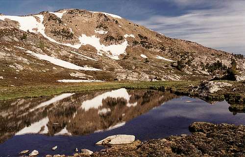
![Alpine Tarn]()
Geology, Wilderness Areas, and History
Geologically, the range can be divided into five areas based on the age and the character of the rock. Politically, it’s easier to look at the range according to the four separate, noncontiguous units of the Lee Metcalf Wilderness, an area that protects most of what is the best of this range but is flawed for its lack of connectivity, which allows development that both mars the scenery and also impedes the natural ranges and migration routes of wildlife.Lee Metcalf Wilderness
•Beartrap Canyon Unit: This, the northernmost and newest unit, is a beautiful mountain canyon harboring a blue-ribbon trout stream and thrilling rapids. Accessed from west of Bozeman off MT 84, this unit has a nice trail running north-south along the eastern side of the river. The first three miles are open and yield spectacular views of the cliffs walling in the river’s west side. Beyond that, the canyon narrows and the trail becomes more rugged, and the rapids become larger and more forceful. Several backcountry campsites along the way offer million-dollar views of this wild canyon, which is also set in grizzly territory.•Spanish Peaks Unit: The most popular area of the range, the Spanish Peaks, the crest of which consists of gneiss that is 1.6 billion years old, are also the oldest mountains in the range, predating the rest of the range by some 50-60 million years. Exactly why these mountains are named as they are is not known, but the likelihood is that the term relates to the prospectors who headed to Montana from Mexico. The Spanish Peaks run from Beartrap Canyon to the section of Gallatin Canyon near the town of Big Sky; at the southeast end, cracks in gneiss fins attract rock climbers. Peaks in the Spanish Peaks Unit that offer some of the best climbing are Gallatin Peak and Beehive Peak (Class 3 and 4 standard routes, respectively).
![Beehive Peak]() Beehive Peak
•Taylor-Hilgard Unit: This is the highest and arguably the most majestic section of the range, and it is the largest of the wilderness units at 141,000 acres, nearly twice the size of the Spanish Peaks Unit. In this section, one will find classic Madison peaks such as Hilgard, Koch, and Echo and intriguing ones such as Sphinx and Helmet. The peaks in the Taylor-Hilgard Unit consist mostly of metamorphic rocks that are nearly 3 billion years old (they used to be topped with sedimentary rocks, but those are mostly gone, ripped away through the ages). The faulting that uplifted these peaks also formed the Teton Range, and the southern portion of the area is still rising. Also, this area illustrates the geologic volatility that still underlies the Yellowstone region (in fact, Yellowstone is geologically ripe for a volcanic eruption that would utterly change the Yellowstone that we know today). On August 17, 1959, the faults riddling the region produced an earthquake measuring 7.1 on the Richter Scale. A resulting landslide into Madison Canyon dammed the river and killed 28 people. Earthquake Lake, just west of human-created Hebgen Lake, stands today as one visual consequence of the slide.
Beehive Peak
•Taylor-Hilgard Unit: This is the highest and arguably the most majestic section of the range, and it is the largest of the wilderness units at 141,000 acres, nearly twice the size of the Spanish Peaks Unit. In this section, one will find classic Madison peaks such as Hilgard, Koch, and Echo and intriguing ones such as Sphinx and Helmet. The peaks in the Taylor-Hilgard Unit consist mostly of metamorphic rocks that are nearly 3 billion years old (they used to be topped with sedimentary rocks, but those are mostly gone, ripped away through the ages). The faulting that uplifted these peaks also formed the Teton Range, and the southern portion of the area is still rising. Also, this area illustrates the geologic volatility that still underlies the Yellowstone region (in fact, Yellowstone is geologically ripe for a volcanic eruption that would utterly change the Yellowstone that we know today). On August 17, 1959, the faults riddling the region produced an earthquake measuring 7.1 on the Richter Scale. A resulting landslide into Madison Canyon dammed the river and killed 28 people. Earthquake Lake, just west of human-created Hebgen Lake, stands today as one visual consequence of the slide.
![Hilgard and North Hilgard...]() Hilgard Peak-- by b.
•Monument Mountain Unit: East of the main range and abutting part of the northwestern boundary of Yellowstone National Park (the Gallatin River is the geographical boundary between the Madison Range and the Gallatin Range, which fills much of northwestern Yellowstone), this unit is the smallest of the wilderness area’s three mountainous units, and the mountains, which are the range’s most geologically diverse, are also the lowest ones of the three units. This unit is probably the least-traveled and least-known to mountaineers, though, so solitude and a sense of discovery await those willing to forsake the jewels of the range for them.
Hilgard Peak-- by b.
•Monument Mountain Unit: East of the main range and abutting part of the northwestern boundary of Yellowstone National Park (the Gallatin River is the geographical boundary between the Madison Range and the Gallatin Range, which fills much of northwestern Yellowstone), this unit is the smallest of the wilderness area’s three mountainous units, and the mountains, which are the range’s most geologically diverse, are also the lowest ones of the three units. This unit is probably the least-traveled and least-known to mountaineers, though, so solitude and a sense of discovery await those willing to forsake the jewels of the range for them.
 Beehive Peak
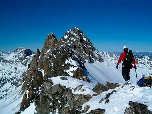 Hilgard Peak-- by b.
So why is the Lee Metcalf Wilderness not contiguous as most other wilderness areas are, and why is the Madison Range so much more impacted by human development than the other Yellowstone Ecosystem ranges are? Ultimately, it boils down to politics. Back in the 1880s when the federal government was pushing the development of railroads through the West, it granted a great deal of land to the Northern Pacific Railway Company. The result was a checkerboard pattern of land ownership; the government and the railroad controlled square-mile sections of land that were alternating and offset. Later, the Burlington Northern Company took ownership of the Northern Pacific lands, and it began major logging operations. A nearly identical history befell the neighboring Gallatin Range.
During the next century, taking into the late parts of it, in fact, land exchanges undid most of the checkerboard ownership patterns and largely restored the Gallatins to federal ownership and oversight. This did not happen with the Madison Range, however. But hopes for protecting the range were high when Lee Metcalf, a Montana Senator, in the 1970s led an effort to designate about 600,000 contiguous acres of the Madison Range as wilderness. But John Melcher, another Montana Senator, offered a bill that satisfied people from the timber and snowmobile industries. Melcher’s bill put great amounts of land under private ownership and split the proposed wilderness into different sections. And Melcher’s bill prevailed. The result was that less than 50% of the Madison Range has wilderness status, and excellent habitat for animals such as grizzlies and elk that cover a lot of territory has been disrupted by logging, resorts, and home building (marked by an expanding presence of trophy homes and highly exclusive resort communities).
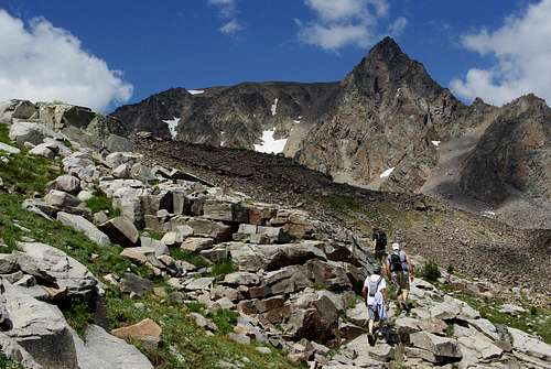
![Imp Peak - South Aspect]() Imp Peak-- by bigsky801
Imp Peak-- by bigsky801
![SE couloir]() By bigsky801
It wasn’t supposed to have been this way, not even with the development of the ski resort. During the planning and building stages in the early 1970s, developers worked with conservationists and agreed to compromises that placed limits on road construction and required preserving the mountain’s integrity as much as possible. For example, after a bulldozer pushed a large piece of equipment up the mountain, a ground crew had to hike up the track-caused scar and flip all disturbed rocks back so that their lichen sides faced up again. For the time, it was almost a model example of how conservationist, commercial, and recreational interests could coexist if they had to. To someone seeing any ski resort as an unacceptable blemish on a mountain but realizing his was a minority view that would not gain much traction, the original plan for Lone Mountain probably looked to be about as good as it could get.
By bigsky801
It wasn’t supposed to have been this way, not even with the development of the ski resort. During the planning and building stages in the early 1970s, developers worked with conservationists and agreed to compromises that placed limits on road construction and required preserving the mountain’s integrity as much as possible. For example, after a bulldozer pushed a large piece of equipment up the mountain, a ground crew had to hike up the track-caused scar and flip all disturbed rocks back so that their lichen sides faced up again. For the time, it was almost a model example of how conservationist, commercial, and recreational interests could coexist if they had to. To someone seeing any ski resort as an unacceptable blemish on a mountain but realizing his was a minority view that would not gain much traction, the original plan for Lone Mountain probably looked to be about as good as it could get.
 Imp Peak-- by bigsky801
Lone Mountain and Big Sky
If there is any one place to look in the Madison Range for an example of the impact development has had on the region, it is Lone Mountain. Standing apart as its name suggests, Lone Mountain is arguably the most beautiful mountain in the range and one of the most beautiful in the country. Its form is reminiscent of the Cascade volcanoes, but its conical shape and long ridges are due not to volcanism (though that is responsible for much of the rock comprising the mountain) but to erosion by streams and erstwhile glaciers. When it has enough snow, it offers numerous fine snow climbs, glisse descents, and snowboarding opportunities. Those qualities, plus the failure to bestow upon it the protection that comes with wilderness inclusion (the southwestern flanks of the mountain do abut the Taylor-Hilgard Unit), have also made it a major ski area marked by lifts, clearcuts, and roads on the mountain and by expanding commercial and residential development in the nearby Big Sky community.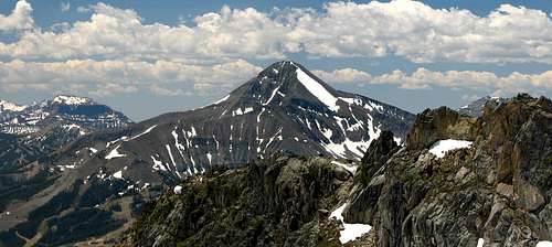 By bigsky801
Predictably, though, the plans and agreements in time fell to growing pressure on infrastructure such as roads and sewer systems and to the interests of developers (and their clients, of course). Now, to many people (by no means all and probably not a majority of area residents), the mountain and the Big Sky area are eyesores and/or playgrounds catering to the rich. For example, during the late 1990s, a former timber executive opened a private community welcoming anyone as long as he had a net worth of at least $5 million. Parts of the north and west sides of the mountain, according to Thomas Turiano’s Select Peaks of the Greater Yellowstone, now sport “No Trespassing” signs blocking legal access to the public. People of any means can hike or ski on the mountain, yes, but the character of the area has substantially and probably permanently changed.
From T Sharp: "In addition to Big Sky, there has been the recent development of the Moonlight Basin property on the West side of Lone Peak. As with most ski areas the real estate associated with the ski area is the main driving force. Lone Mountain unlike Lolo Peak [another proposed ski area in MT.],is almost entirely under private ownwership which greatly reduces the influence of the general public on develpment issues." There may be no other U.S. mountain of Lone Mountain’s stature and beauty that has been so impacted by resort development. Not even in Colorado, where the ski industry has so much presence and clout, is there such a mountain, though some would argue that mountains such as Mount Evans and Pikes Peak, the latter especially, have been ruined by other types of commercialization and development, and Wilson Peak, one of the state's most striking, has faced private-property issues. Mount Washington in New Hampshire, with its toll road and cog railway, also comes to mind. I personally think it's a shame that a mountain as exceptional as Lone Mountain is had to be developed the way it was. But others see it as not that big a deal and think it's a great place. I'm not the one to say which view is right; in a way, both could be. What does seem clear is that Lone Mountain, whether you love its state, hate it, or really don't care, stands as a reminder of what many more banner mountains in the Yellowstone area and the rest of the country would become if they fell under either private ownership or federal oversight that is even more lax than many feel it is already. So enjoy it, but be wary of more like it!
Red Tape
In the publicly accessible areas, there is only the usual red tape involving wilderness-use regulations (mostly involving campfires, food storage, and camping near water sources—check signboards before hitting trails). Always remember that this is bear country. Because so much land in the Madison Range and its vicinity is privately owned, one must be aware of posted restrictions. Remember that no matter what you think of private landowners blocking access to the mountains, the law will not be on your side if you are caught trespassing. If you suspect that a landowner has illegally closed a public road or other access point (this is increasingly occurring on public lands and roads in the West), it is better to notify the proper authorities than to take matters into your own hands.Camping and Lodging
Several campgrounds exist in the Gallatin National Forest in the vicinity of Hebgen Lake and along U.S. 191 north of West Yellowstone. These campgrounds charge fees and have water, toilets, and grills or fire rings, and the sites are available on a first-come, first-served basis. There are also privately owned campgrounds in nearby communities, and some trailheads offer free camping at undeveloped sites. Bozeman and West Yellowstone offer a wide array of accommodations ranging from chain hotels and motels to locally owned motels and from luxury rooms to moderately priced units.Lodging is also available in the vicinity of Big Sky, though it is more limited and could be very expensive. The last time I passed through Ennis (2002), a very small town on the west side of the range, there was one motel there. Big Sky is near the center of the range and is the closest town to most trailheads. If, though, Big Sky is not an option, then Bozeman makes sense if one is concentrating on the Beartrap Canyon or Spanish Peaks Unit, and if one’s focus is on the Taylor-Hilgard or the Monument Mountain Unit, then West Yellowstone makes a good choice. Both Bozeman and West Yellowstone are very busy during peak tourist seasons.
Bozeman is larger and has a growing presence of big-box and other chain retail stores, but Yellowstone has more of a tacky tourist feel and has a seemingly endless stream of traffic heading to and from the western entrance of Yellowstone National Park. Bottom line: as any other place does, each location has its share of assets, charms and flaws. West Yellowstone, which bills itself as the snowmobiling capital of the country, is also perhaps THE primary front in the battle over snowmobile use on public lands, especially national parks.